
-
Federal
MERRA-2 tavgM_2d_aer_Nx: 2d,Monthly mean,Time-averaged,Single-Level,Assimilation,Aerosol Diagnostics 0.625 x 0.5 degree V5.12.4 (M2TMNXAER) at GES DISC
National Aeronautics and Space Administration —
M2TMNXAER (or tavgM_2d_aer_Nx) is a time-averaged 2-dimensional monthly mean data collection in Modern-Era Retrospective analysis for Research and Applications... -
Federal
TERRA MODIS High Resolution Level 3 daily aerosol data, 0.1x0.1 degree grid Version 001 (AER_DBDT_D10KM_L3_MODIS_TERRA) at GES DISC
National Aeronautics and Space Administration —
This High-Resolution (0.1 x 0.1 degree) Level 3 daily Aerosol Optical Depth (AOD) product is generated by combining two Moderate Resolution Imaging Spectroradiometer... -
Federal
SBUV2/NOAA-18 Ozone (O3) Profile and Total Column Ozone 1 Month Zonal Mean L3 Global 5.0 degree Latitude Zones V1 (SBUV2N18L3zm) at GES DISC
National Aeronautics and Space Administration —
The Solar Backscattered Ultraviolet (SBUV) from NOAA-18 Level-3 monthly zonal mean (MZM) product (SBUV2N18L3zm) is derived from the Level-2 retrieved ozone profiles.... -
Federal
GLDAS Catchment Land Surface Model L4 daily 0.25 x 0.25 degree GRACE-DA1 V2.2 (GLDAS_CLSM025_DA1_D) at GES DISC
National Aeronautics and Space Administration —
NASA Global Land Data Assimilation System Version 2 (GLDAS-2) has three components: GLDAS-2.0, GLDAS-2.1, and GLDAS-2.2. GLDAS-2.0 is forced entirely with the... -
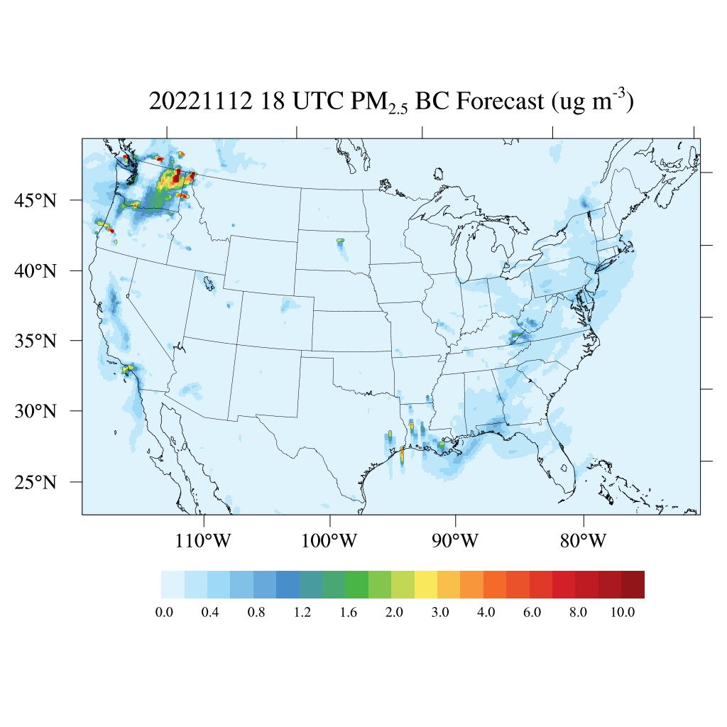
Federal
HAQES 3-Hourly Ensemble mean surface PM2.5 Black Carbon concentration, North America V1 (HAQES_NA_PM25_BC) at GES DISC
National Aeronautics and Space Administration —
This product provides HAQES 3-hourly ensemble mean surface PM2.5 Black Carbon concentration over the continental United States (CONUS) and surrounding regions. The... -
Federal
GPM MHS on NOAA18 (GPROF) Radiometer Precipitation Profiling L3 1 month 0.25 degree x 0.25 degree V07 (GPM_3GPROFNOAA18MHS_CLIM) at GES DISC
National Aeronautics and Space Administration —
Version 07 is the current version of the data set. Older versions are no longer available and have been superseded by Version 07. The "CLIM" products differ from... -
Federal
MERRA-2 tavg3_3d_trb_Np: 3d,3-Hourly,Time-Averaged,Pressure-Level,Assimilation,Turbulence Diagnostics 0.625 x 0.5 degree V5.12.4 (M2T3NPTRB) at GES DISC
National Aeronautics and Space Administration —
M2T3NPTRB (or tavg3_3d_trb_Np) is a 3-dimensional 3-hourly time averaged data collection in Modern-Era Retrospective analysis for Research and Applications version 2... -
Federal
MLS/Aura Level 2 Ozone (O3) Mixing Ratio V005 (ML2O3) at GES DISC
National Aeronautics and Space Administration —
ML2O3 is the EOS Aura Microwave Limb Sounder (MLS) standard product for ozone derived from radiances measured by the 240 GHz radiometer. The data version is 5.0.... -
Federal
AQUA MODIS High Resolution Level 3 daily aerosol data, 0.1x0.1 degree grid Version 001 (AER_DBDT_D10KM_L3_MODIS_AQUA) at GES DISC
National Aeronautics and Space Administration —
This High-Resolution (0.1 x 0.1 degree) Level 3 daily Aerosol Optical Depth (AOD) product is generated by combining two Moderate Resolution Imaging Spectroradiometer... -
Federal
GPM AMSUB on NOAA15 (GPROF) Climate-based Radiometer Precipitation Profiling L3 1 day 0.25 degree x 0.25 degree V07 (GPM_3GPROFNOAA15AMSUB_DAY_CLIM) at GES DISC
National Aeronautics and Space Administration —
The "CLIM" products differ from their "regular" counterparts (without the "CLIM" in the name) by the ancillary data they use. They are Climate-Reference products,... -
Federal
Sounder SIPS: Suomi NPP CrIMSS Level 3 Comprehensive Quality Control Gridded Daily CHART Normal Spectral Resolution V1
National Aeronautics and Space Administration —
The objective of this limited edition data collection is to examine products generated by the Climate Heritage AIRS Retrieval Technique (CHART) algorithm to analyze... -
Federal
MERRA-2 instM_3d_asm_Np: 3d,Monthly mean,Instantaneous,Pressure-Level,Assimilation,Assimilated Meteorological Fields 0.625 x 0.5 degree V5.12.4 (M2IMNPASM) at GES DISC
National Aeronautics and Space Administration —
M2IMNPASM (or instM_3d_asm_Np) is an instantaneous 3-dimensional monthly mean data collection in Modern-Era Retrospective analysis for Research and Applications... -
Federal
NOAA20 VIIRS High Resolution Level 3 daily aerosol data, 0.1x0.1 degree grid Version 001 (AER_DBDT_D10KM_L3_VIIRS_NOAA20) at GES DISC
National Aeronautics and Space Administration —
This High-Resolution (0.1 x 0.1 degree) Level 3 daily Aerosol Optical Depth (AOD) product is generated by combining two Visible Infrared Imaging Radiometer Suite... -
Federal
TROPESS CrIS-SNPP L2 Methane for Reanalysis Stream, Summary Product V1 (TRPSYL2CH4CRSRS) at GES DISC
National Aeronautics and Space Administration —
The TROPESS CrIS-SNPP L2 Methane for Reanalysis Stream, Summary Product contains the vertical distribution of the retrieved atmospheric state of methane (CH4), and... -
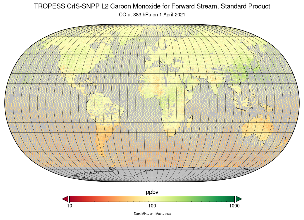
Federal
Sounder SIPS: AQUA AIRS IR + MW Level 2 CLIMCAPS: Atmosphere, cloud and surface geophysical state V2 (SNDRAQIML2CCPRET) at GES DISC
National Aeronautics and Space Administration —
WARNING: To users of the derived product “co_mmr_midtrop” (carbon monoxide mass mixing ratio to dry air [kg/kg] at ~500 hPa). This variable has a significant bias due... -
Federal
Sentinel-5P TROPOMI Tropospheric Ozone Column V1 (S5P_L2__O3_TCL) at GES DISC
National Aeronautics and Space Administration —
Starting from July 13th in 2020, five Sentinel-5P TROPOMI level-2 products including total and tropospheric column ozone, sulfur dioxide, CLOUD, and formaldehyde have... -
Federal
CAR Discover AQ BRDF Measurements V2 (CAR_DISCOVERAQ_BRDF_2)
National Aeronautics and Space Administration —
DISCOVER-AQ, a NASA Earth Venture program funded mission, stands for Deriving Information on Surface Conditions from Column and Vertically Resolved Observations... -
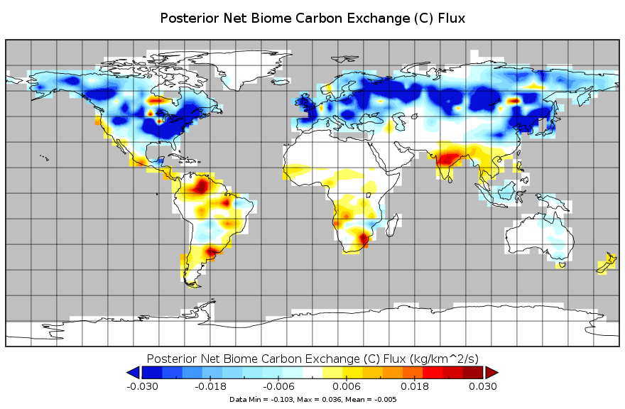
Federal
Carbon Monitoring System Flux for Posterior Total Carbon L4 V1 (CMSFluxTotalpost) at GES DISC
National Aeronautics and Space Administration —
This dataset provides the Carbon Flux for Posterior Total Carbon.The NASA Carbon Monitoring System (CMS) is designed to make significant contributions in... -
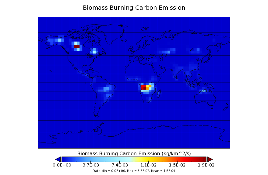
Federal
Carbon Monitoring System Carbon Flux for Fire L4 V1 (CMSFluxFire) at GES DISC
National Aeronautics and Space Administration —
This dataset provides the Carbon Flux for Fires.The NASA Carbon Monitoring System (CMS) is designed to make significant contributions in characterizing, quantifying,... -
Federal
FLDAS Noah Land Surface Model L4 Global Monthly 0.1 x 0.1 degree (MERRA-2 and CHIRPS) V001 (FLDAS_NOAH01_C_GL_M) at GES DISC
National Aeronautics and Space Administration —
This dataset contains a series of land surface parameters simulated from the Noah 3.6.1 model in the Famine Early Warning Systems Network (FEWS NET) Land Data...

Official websites use .gov
A
.gov website belongs to an official government
organization in the United States.
Secure .gov websites use HTTPS
A
lock (
) or https:// means you’ve safely connected to
the .gov website. Share sensitive information only on official,
secure websites.