
-
Federal
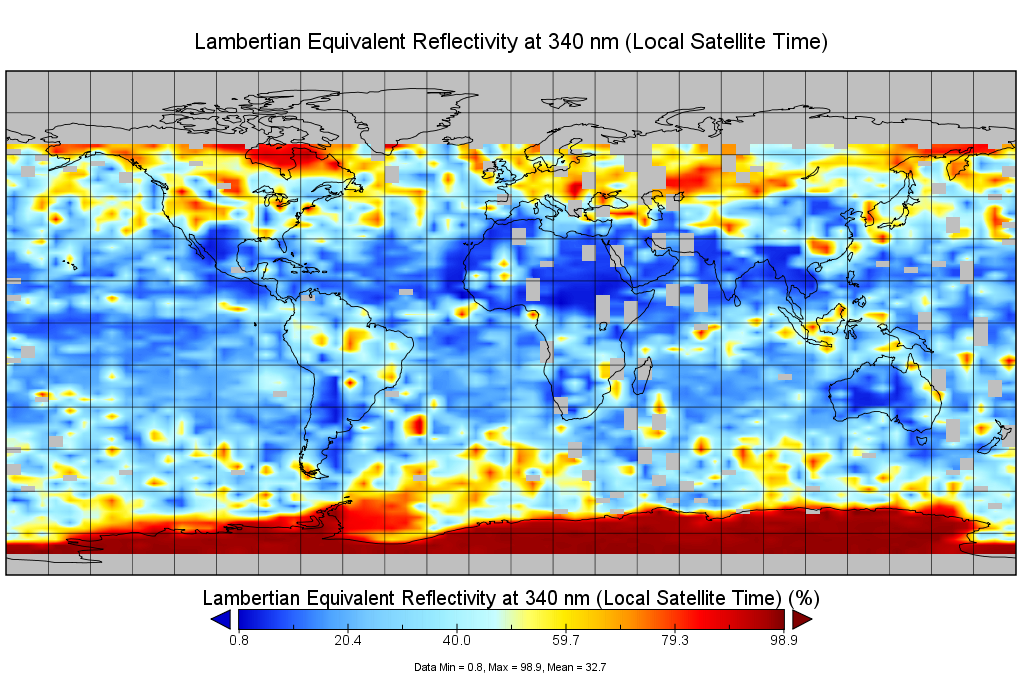
Multi-Satellite Lambertian Equivalent Reflectivity (Local Satellite Time) 10-Day L3 Global 2.0x5.0deg Lat/Lon Grid V1 (MSLERLSTL3d10) at GES DISC
National Aeronautics and Space Administration —
The Multi-Satellite Lambertian Equivalent Reflectivity (Local Satellite Time) 10-Day L3 Global 2.0x5.0deg Lat/Lon Grid data product is derived from multi-satellite... -
Federal
Multi-Satellite Lambertian Equivalent Reflectivity (Noon Normalized) 10-Day L3 Global 2.0x5.0deg Lat/Lon Grid V1 (MSLERNNL3d10) at GES DISC
National Aeronautics and Space Administration —
The Multi-Satellite Lambertian Equivalent Reflectivity (Noon Normalized) 10-Day L3 Global 2.0x5.0deg Lat/Lon Grid data product is derived from multi-satellite Solar... -
Federal
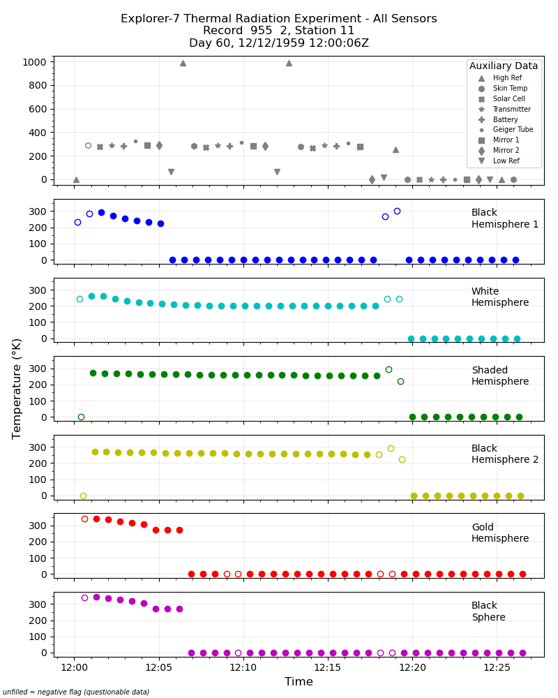
Explorer-7 Thermal Radiation Experiment Temperature Values from All Sensors V001 (EXP7L1TRTALL) at GES DISC
National Aeronautics and Space Administration —
Explorer-7 Thermal Radiation Experiment Temperature Values from All Sensors product contains temperature readings from all five bolometers in order to measure solar,... -
Federal
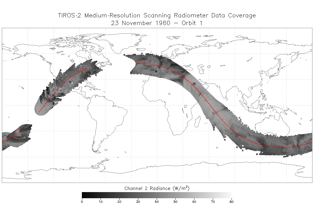
TIROS-2 Medium-Resolution Scanning Radiometer Level 1 Final Meteorological Radiation Data V001 (TIROS2L1FMRT) at GES DISC
National Aeronautics and Space Administration —
TIROS-2 Medium-Resolution Scanning Radiometer Level 1 Final Meteorological Radiation Data (FMRT) product contains radiances expressed in five infrared/visible... -
Federal
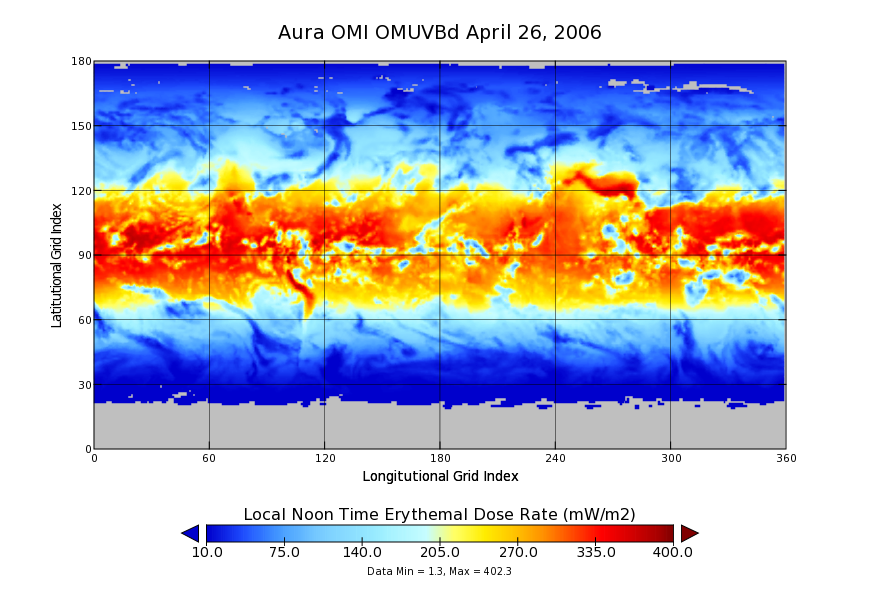
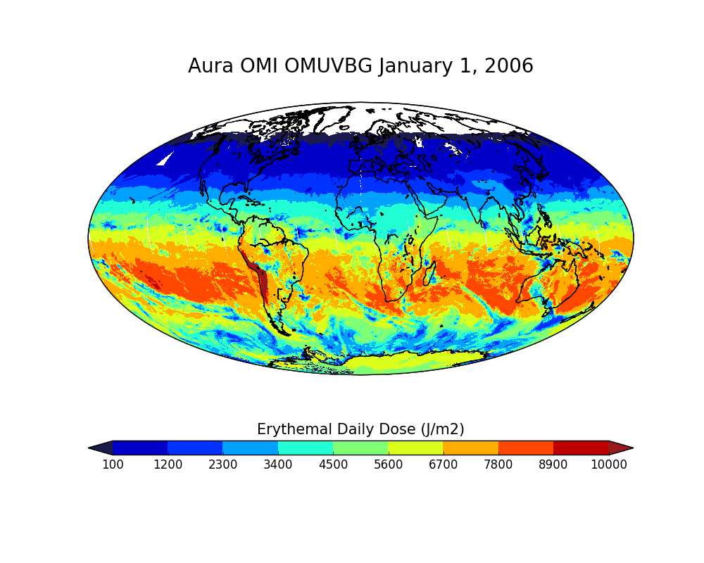
OMI/Aura Surface UVB Irradiance and Erythemal Dose Daily L3 Global Gridded 1.0 degree x 1.0 degree V3 (OMUVBd) at GES DISC
National Aeronautics and Space Administration —
This is Level-3 daily global gridded Aura-OMI Spectral Surface UVB Irradiance and Erythemal Dose product (OMUVBd). The OMUVBd product contains global erythemally... -
Federal
OMI/Aura Surface UVB Irradiance and Erythemal Dose Daily L2 Global Gridded 0.25 degree x 0.25 degree V3 (OMUVBG) at GES DISC
National Aeronautics and Space Administration —
This is Level-2G daily global gridded Aura-OMI Spectral Surface UVB Irradiance and Erythemal Dose product (OMUVBG). The OMUVBG is a special Level-2 Global Gridded... -
Federal
OMI/Aura Ozone (O3) Total Column Daily L2 Global Gridded 0.25 degree x 0.25 degree V3 (OMTO3G) at GES DISC
National Aeronautics and Space Administration —
This Level-2G daily global gridded product OMTO3G is based on the pixel level OMI Level-2 Total Ozone Product OMTO3. The OMTO3 product is from the enhanced TOMS... -
Federal
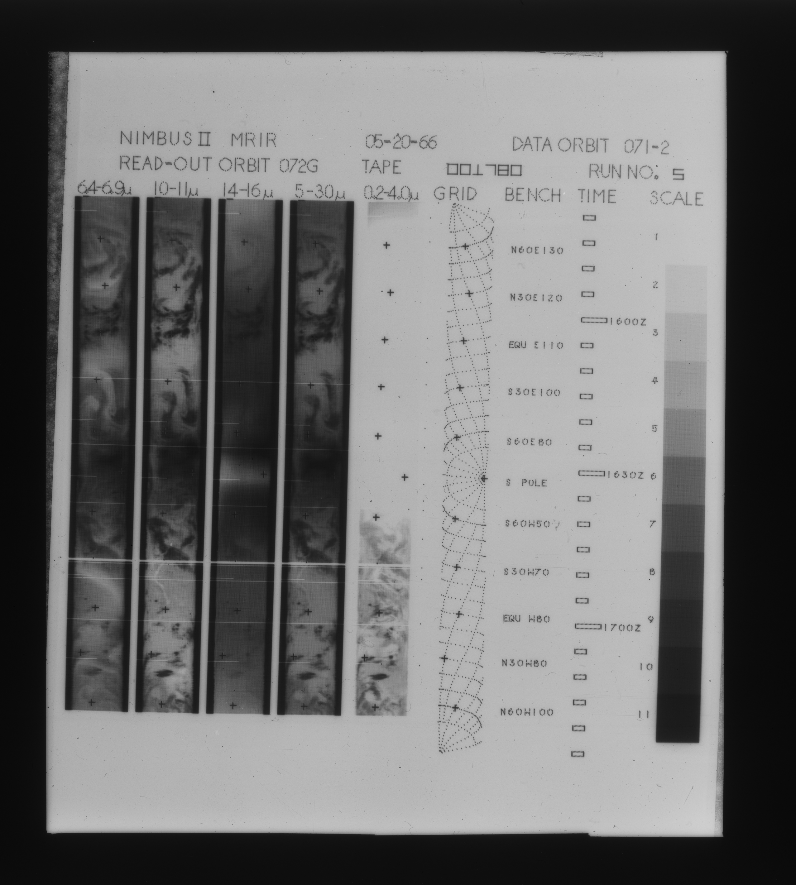
MRIR/Nimbus-3 Level 1 Meteorological Radiation Data V001 (MRIRN3L1) at GES DISC
National Aeronautics and Space Administration —
MRIRN3L1 is the Nimbus-3 Medium-Resolution Infrared Radiometer (MRIR) Level 1 Meteorological Radiance Data product and contain radiances expressed as equivalent... -
Federal
HRIR/Nimbus-3 Level 1 Meteorological Radiation Data V001 (HRIRN3L1) at GES DISC
National Aeronautics and Space Administration —
HRIRN3L1 is the High Resolution Infrared Radiometer (HRIR) Nimbus-3 Level 1 Meteorological Radiance Data (NMRT) product and contains infrared radiances converted to... -
Federal
HRIR/Nimbus-2 Level 1 Meteorological Radiation Data V001 (HRIRN2L1) at GES DISC
National Aeronautics and Space Administration —
HRIRN2L1 is the High Resolution Infrared Radiometer (HRIR) Nimbus-2 Level 1 Meteorological Radiance Data (NMRT) product and contains infrared radiances converted to... -
Federal
MRIR/Nimbus-2 Level 1 Meteorological Radiation Data V001 (MRIRN2L1) at GES DISC
National Aeronautics and Space Administration —
The Nimbus 2 Medium Resolution Infrared Radiometer (MRIR) was designed to measure electromagnetic radiation emitted and reflected from the earth and its atmosphere at... -
Federal
OMI/Aura Surface UV Irradiance 1-orbit L2 Swath 13x24 km V003 (OMUVB) at GES DISC
National Aeronautics and Space Administration —
The Aura Ozone Monitoring Instrument (OMI) Version 003 Surface UV Irradiance Product (OMUVB) is now available from the NASA Goddard Earth Sciences Data and... -
Federal
MiCASA Daily NPP Rh ATMC NEE FIRE FUEL Fluxes 0.1 degree x 0.1 degree
National Aeronautics and Space Administration —
MiCASA is an extensive revision of CASA-GFED3. CASA-GFED3 derives from Potter et al. (1993), diverging in development since Randerson et al. (1996). CASA is a light... -
Federal
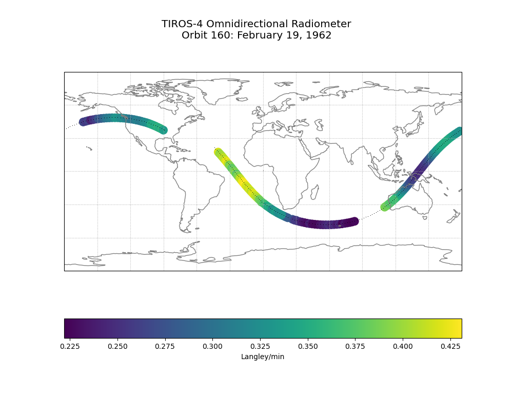
TIROS-4 Low-Resolution Omnidirectional Radiometer Level 1 Radiance Data V001 (TIROS4L1ORR) at GES DISC
National Aeronautics and Space Administration —
The TIROS-4 Low-Resolution Omnidirectional Radiometer Level 1 Radiance Data product contains the longwave radiation values in Langleys/min derived from the black and... -
Federal
Sentinel-5P TROPOMI Irradiance product UVN module L1B V1 (S5P_L1B_IR_UVN) at GES DISC
National Aeronautics and Space Administration —
The Copernicus Sentinel-5 Precursor (Sentinel-5P or S5P) satellite mission is one of the European Space Agency's (ESA) new mission family - Sentinels, and it is a... -
Federal
OCO-3 Level 2 bias-corrected solar-induced fluorescence and other select fields from the IMAP-DOAS algorithm aggregated as daily files, Retrospective processing V10r (OCO3_L2_Lite_SIF) at GES DISC
National Aeronautics and Space Administration —
Version 10r is the current version of the data set. Older versions will no longer be available and are superseded by Version 10r.The Orbiting Carbon Observatory -3... -
Federal
TOMS Earth-Probe Ozone (O3) Total Column 1-Orbit L2 Swath 50 x 50 km V008 (TOMSEPL2) at GES DISC
National Aeronautics and Space Administration —
The Earth Probe (EP) Total Ozone Mapping Spectrometer (TOMS) version 8 orbital swath data product contains total column ozone, UV aerosol index, and Lambertian... -
Federal
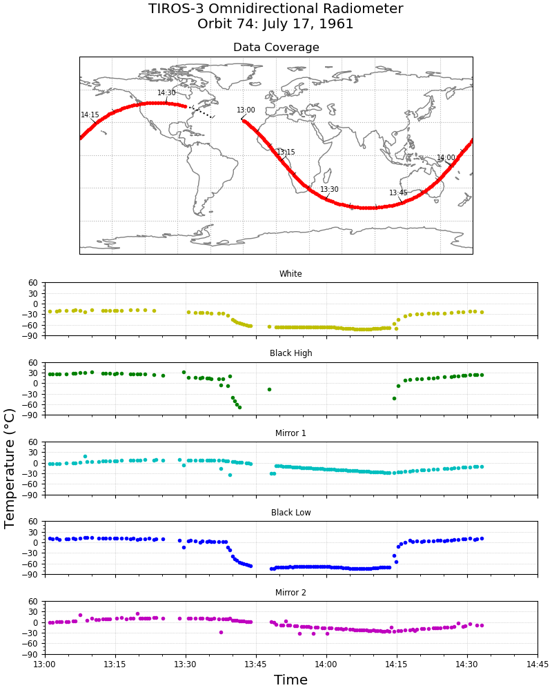
TIROS-3 Low-Resolution Omnidirectional Radiometer Level 1 Temperature Data V001 (TIROS3L1ORT) at GES DISC
National Aeronautics and Space Administration —
The TIROS-3 Low-Resolution Omnidirectional Radiometer Level 1 Temperature Data product contains the black and white sensor temperature values in degrees Celsius. The... -
Federal
OMI/Aura Ozone (O3) Total Column Daily L2 Global Gridded 0.25 degree x 0.25 degree V004 (OMTO3G) at GES DISC
National Aeronautics and Space Administration —
This Level-2G daily global gridded product OMTO3G is based on the pixel level OMI Level-2 Total Ozone Product OMTO3. The OMTO3 product is from the enhanced TOMS... -
Federal
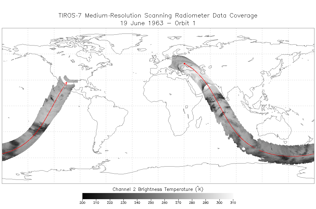
TIROS-7 Medium-Resolution Scanning Radiometer Level 1 Final Meteorological Radiation Data V001 (TIROS7L1FMRT) at GES DISC
National Aeronautics and Space Administration —
TIROS-7 Medium-Resolution Scanning Radiometer Level 1 Final Meteorological Radiation Data (FMRT) product contains radiances expressed in five infrared/visible...

Official websites use .gov
A
.gov website belongs to an official government
organization in the United States.
Secure .gov websites use HTTPS
A
lock (
) or https:// means you’ve safely connected to
the .gov website. Share sensitive information only on official,
secure websites.