
-
Federal
GPM IMERG Final Precipitation L3 1 day 0.1 degree x 0.1 degree V07 (GPM_3IMERGDF) at GES DISC
National Aeronautics and Space Administration —
Version 07 is the current version of the data set. Older versions will no longer be available and have been superseded by Version 07.The Integrated Multi-satellitE... -
Federal
OMI/Aura Sulfur Dioxide (SO2) Total Column Daily L3 1 day Best Pixel in 0.25 degree x 0.25 degree V3 (OMSO2e) at GES DISC
National Aeronautics and Space Administration —
The OMI science team produces this Level-3 Aura/OMI Global OMSO2e Data Products (0.25 degree Latitude/Longitude grids). In this Level-3 daily global SO2 data product,... -
Federal
HAQAST Sentinel-5P TROPOMI Nitrogen Dioxide (NO2) CONUS Seasonal Level 3 0.01 x 0.01 Degree Gridded Data V2.4 (HAQ_TROPOMI_NO2_CONUS_S_L3) at GES DISC
National Aeronautics and Space Administration —
This product provides level 3 seasonal averages of tropospheric Nitrogen dioxide (NO2) vertical column density derived from the level 2 Tropospheric Monitoring... -
Federal
CAR INTEX-B Long-range Pollution Transportation L1 V1 (CAR_INTEXB_L1C) at GES DISC
National Aeronautics and Space Administration —
INTEX-B (Intercontinental Chemical Transport Experiment-Phase B) focuses on the long-range transport of pollution, global atmospheric photochemistry, and the effects... -
Federal
HAQAST Sentinel-5P TROPOMI Nitrogen Dioxide (NO2) CONUS Monthly Level 3 0.01 x 0.01 Degree Gridded Data V2.4 (HAQ_TROPOMI_NO2_CONUS_M_L3) at GES DISC
National Aeronautics and Space Administration —
This product provides level 3 monthly averages of tropospheric Nitrogen dioxide (NO2) vertical column density derived from the level 2 Tropospheric Monitoring... -
Federal
GPM IMERG Late Precipitation L3 1 day 0.1 degree x 0.1 degree V07 (GPM_3IMERGDL) at GES DISC
National Aeronautics and Space Administration —
Version 07 is the current version of the data set. Older versions will no longer be available and have been superseded by Version 07.The Integrated Multi-satellitE... -
Federal
OMPS-NPP L2 LP Aerosol Extinction Vertical Profile swath daily 3slit V2.5 (OMPS_NPP_LP_L2_AER_DAILY) at GES DISC
National Aeronautics and Space Administration —
The OMPS-NPP L2 LP Aerosol Extinction Vertical Profile swath daily 3slit (AER) product contains the retrieved aerosol extinction coefficients measured by the Ozone... -
Federal
Sounder SIPS: Suomi NPP CrIS Level-1B NSR Calibration Subset: Summary V2 (SNDRSNIL1BCALSUBSUMN) at GES DISC
National Aeronautics and Space Administration —
The CrIS/ATMS instruments used for this product are on board the Suomi National Polar-orbiting Partnership (SNPP) platform and use the Normal Spectral Resolution... -
Federal
MERRA-2 tavgU_3d_trb_Np: 3d,diurnal,Time-Averaged,Pressure-Level,Assimilation,Turbulence Diagnostics 0.625 x 0.5 degree V5.12.4 (M2TUNPTRB) at GES DISC
National Aeronautics and Space Administration —
M2TUNPTRB (or tavgU_3d_trb_Np) is a 3-dimensional monthly diurnal means data collection in Modern-Era Retrospective analysis for Research and Applications version 2... -
Federal
MERRA-2 tavgU_2d_aer_Nx: 2d,diurnal,Time-averaged,Single-Level,Assimilation,Aerosol Diagnostics 0.625 x 0.5 degree V5.12.4 (M2TUNXAER) at GES DISC
National Aeronautics and Space Administration —
M2TUNXAER (or tavgU_2d_aer_Nx) is a time-averaged 2-dimensional monthly diurnal means data collection in Modern-Era Retrospective analysis for Research and... -
Federal
MERRA-2 inst3_3d_asm_Nv: 3d,3-Hourly,Instantaneous,Model-Level,Assimilation,Assimilated Meteorological Fields 0.625 x 0.5 degree V5.12.4 (M2I3NVASM) at GES DISC
National Aeronautics and Space Administration —
M2I3NVASM (or inst3_3d_asm_Nv) is an instantaneous 3-dimensional 3-hourly data collection in Modern-Era Retrospective analysis for Research and Applications version 2... -
Federal
MERRA-2 tavg1_2d_ocn_Nx: 2d,1-Hourly,Time-Averaged,Single-Level,Assimilation,Ocean Surface Diagnostics 0.625 x 0.5 degree V5.12.4 (M2T1NXOCN) at GES DISC
National Aeronautics and Space Administration —
M2T1NXOCN (or tavg1_2d_ocn_Nx) is an hourly time-averaged 2-dimensional data collection in Modern-Era Retrospective analysis for Research and Applications version 2... -
Federal
GLDAS Catchment Land Surface Model L4 daily 0.25 x 0.25 degree GRACE-DA1 V2.2 (GLDAS_CLSM025_DA1_D) at GES DISC
National Aeronautics and Space Administration —
NASA Global Land Data Assimilation System Version 2 (GLDAS-2) has three components: GLDAS-2.0, GLDAS-2.1, and GLDAS-2.2. GLDAS-2.0 is forced entirely with the... -
Federal
AIRS/Aqua L2G Precipitation Estimate (AIRS-only) V7.0 at GES DISC
National Aeronautics and Space Administration —
The Atmospheric Infrared Sounder (AIRS) is a grating spectrometer (R = 1200) aboard the second Earth Observing System (EOS) polar-orbiting platform, EOS Aqua. This... -
Federal
AIRS/Aqua L2G Precipitation Estimate (AIRS-only) V006 (AIRG2SSD_IRonly) at GES DISC
National Aeronautics and Space Administration —
The Atmospheric Infrared Sounder (AIRS) is a grating spectrometer (R = 1200) aboard the second Earth Observing System (EOS) polar-orbiting platform, EOS Aqua. This... -
Federal
MERRA-2 tavgU_2d_csp_Nx: 2d,diurnal,Time-averaged,Single-Level,Assimilation,COSP Satellite Simulator 0.625 x 0.5 degree V5.12.4 (M2TUNXCSP) at GES DISC
National Aeronautics and Space Administration —
M2TUNXCSP (or tavgU_2d_csp_Nx) is a time-averaged 2-dimensional monthly diurnal means data collection in Modern-Era Retrospective analysis for Research and... -
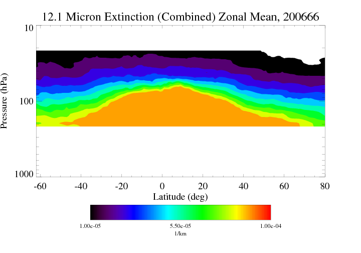
Federal
HIRDLS/Aura Level 3 Extinction at 12.1 Microns 1deg Lat Zonal Fourier Coefficients V007 (H3ZFC12MEXT) at GES DISC
National Aeronautics and Space Administration —
The "HIRDLS/Aura Level 3 Extinction at 12.1 Microns Zonal Fourier Coefficients" version 7 data product (H3ZFC12MEXT) contains the entire mission (~3 years) of HIRDLS... -
Federal
HIRDLS/Aura Level 3 Chlorine Nitrate (ClONO2) 1deg Lat Zonal Fourier Coefficients V007 (H3ZFCCLONO2) at GES DISC
National Aeronautics and Space Administration —
The "HIRDLS/Aura Level 3 Chlorine Nitrate (ClONO2) Zonal Fourier Coefficients" version 7 data product (H3ZFCCLONO2) contains the entire mission (~3 years) of HIRDLS... -
Federal
MLS/Aura Level 3 Daily Binned Hydrogen Cyanide (HCN) Mixing Ratio on Assorted Grids V004 (ML3DBHCN) at GES DISC
National Aeronautics and Space Administration —
ML3DBHCN is the EOS Aura Microwave Limb Sounder (MLS) daily binned on various vertical grids product for hydrogen cyanide (HCN) derived from radiances measured... -
Federal
MLS/Aura L1 Radiances from Filter Banks for THz V005 (ML1RADT) at GES DISC
National Aeronautics and Space Administration —
ML1RADT is the EOS Aura Microwave Limb Sounder (MLS) product containing the level 1 radiances from the filter banks for the GHz radiometers. The data version is 5.0....

Official websites use .gov
A
.gov website belongs to an official government
organization in the United States.
Secure .gov websites use HTTPS
A
lock (
) or https:// means you’ve safely connected to
the .gov website. Share sensitive information only on official,
secure websites.