
-
Federal
Ground-Based Global Navigation Satellite System (GNSS) Data (1-second sampling, real-time streams) from NASA CDDIS
National Aeronautics and Space Administration —
Global Navigation Satellite System (GNSS) real-time 1 to multi-second sampled data available from the Crustal Dynamics Data Information System (CDDIS). Global... -
Federal
Gene expression profiling in human fibroblast after low-LET irradiation
National Aeronautics and Space Administration —
Exposure to radiation provokes cellular responses controlled in part by gene expression networks. MicroRNAs (miRNAs) are small non-coding RNAs which mostly regulate... -
Federal
GLDAS Catchment Land Surface Model L4 daily 0.25 x 0.25 degree GRACE-DA1 V2.2 (GLDAS_CLSM025_DA1_D) at GES DISC
National Aeronautics and Space Administration —
NASA Global Land Data Assimilation System Version 2 (GLDAS-2) has three components: GLDAS-2.0, GLDAS-2.1, and GLDAS-2.2. GLDAS-2.0 is forced entirely with the... -
Federal
Ocean Color
National Aeronautics and Space Administration —
Satellite-derived Ocean Color Data sets from historical and currently operational NASA and International Satellite missions including the NASA Coastal Zone Color... -
Federal
CERES and GEO-Enhanced TOA, Within-Atmosphere and Surface Fluxes, Clouds and Aerosols 1-Hourly Terra-Aqua-NOAA20 Edition4B
National Aeronautics and Space Administration —
CER_SYN1deg-1Hour_Terra-Aqua-NOAA20_Edition4B is the Clouds and the Earth's Radiant Energy System (CERES) and geostationary (GEO) Top-of-Atmosphere (TOA) Within-... -
Federal
Catalog of Gamma-Ray Bursts
National Aeronautics and Space Administration —
This GRBs Catalog (GRBCAT) records high level information of the GRBs detected since their discovery in 1967. The catalog has been created using publications that... -
Federal
Far Ultraviolet Explorer (FUSE) Observation Log
National Aeronautics and Space Administration —
NASA's FUSE (Far Ultraviolet Spectroscopic Explorer) spacecraft provided spectra in the far-ultraviolet portion of the electromagnetic spectrum (the wavelength range... -
Federal
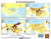
U.S. Population Grids (Summary File 1), 2000: New Orleans Metropolitan Statistical Area, Alpha Version
National Aeronautics and Space Administration —
U.S. Population Grids (Summary File 1), 2000: New Orleans Metropolitan Statistical Area, Alpha Version contains an ARC/INFO Workspace with grids of demographic data... -
Federal
ROSAT North Ecliptic Pole Survey X-Ray Source Catalog
National Aeronautics and Space Administration —
This table contains the ROSAT North Ecliptic Pole (NEP) Survey X-Ray Source Catalog. The sky around the NEP, at RA (J2000.0) = 18h00m00s, Declination (J2000.0) =... -
Federal
HEAO 1 A1 X-Ray Source Catalog
National Aeronautics and Space Administration —
The HEAO 1 A-1 X-Ray Source Catalog contains information about X-ray sources detected with the NRL Large Area Sky Survey Experiment (also referred to as the A-1... -
Federal
ECCO Geometry Parameters for the Lat-Lon-Cap 90 (llc90) Native Model Grid (Version 4 Release 4)
National Aeronautics and Space Administration —
This dataset provides geometric parameters for the lat-lon-cap 90 (llc90) native model grid from the ECCO Version 4 Release 4 (V4r4) ocean and sea-ice state estimate.... -
Federal
Low Elevation Coastal Zone (LECZ) Global Delta Urban-Rural Population and Land Area Estimates, Version 1
National Aeronautics and Space Administration —
The Low Elevation Coastal Zone (LECZ) Global Delta Urban-Rural Population and Land Area Estimates, Version 1 data set provides country-level estimates of urban,... -
Federal
ASTER Digital Elevation Model V003
National Aeronautics and Space Administration —
The Terra Advanced Spaceborne Thermal Emission and Reflection Radiometer (ASTER) Digital Elevation Model (AST14DEM) product is generated using bands 3N (nadir-... -
Federal
ASTER Global Digital Elevation Model NetCDF V003
National Aeronautics and Space Administration —
The Terra Advanced Spaceborne Thermal Emission and Reflection Radiometer (ASTER) Global Digital Elevation Model (GDEM) Version 3 (ASTGTM) provides a global digital... -
Federal
GeoEye-1 Level 1B Panchromatic Satellite Imagery
National Aeronautics and Space Administration —
The GeoEye-1 Level 1B Panchromatic Imagery collection contains satellite imagery acquired from Maxar Technologies (formerly known as DigitalGlobe) by the Commercial... -
Federal
WorldView-3 Level 2A Multispectral 8-Band Satellite Imagery
National Aeronautics and Space Administration —
The WorldView-3 Level 2A Multispectral 8-Band Imagery collection contains satellite imagery acquired from Maxar Technologies (formerly known as DigitalGlobe) by the... -
Federal
MERRA-2 tavgU_3d_udt_Np: 3d,diurnal,Time-Averaged,Pressure-Level,Assimilation,Wind Tendencies 0.625 x 0.5 degree V5.12.4 (M2TUNPUDT) at GES DISC
National Aeronautics and Space Administration —
M2TUNPUDT (or tavgU_3d_udt_Np) is a 3-dimensional monthly diurnal means data collection in Modern-Era Retrospective analysis for Research and Applications version 2... -
Federal
BigFoot Field Data for North American Sites, 1999-2003
National Aeronautics and Space Administration —
The BigFoot project gathered field data for selected EOS Land Validation Sites in North America from 1999 to 2003. Data collected and derived for varying intervals at... -
Federal
Gridded Population of the World, Version 4 (GPWv4): Population Density, Revision 11
National Aeronautics and Space Administration —
The Gridded Population of the World, Version 4 (GPWv4): Population Density, Revision 11 consists of estimates of human population density (number of persons per... -
Federal
MODIS/Terra Land Surface Temperature/Emissivity 8-Day L3 Global 1km SIN Grid V006
National Aeronautics and Space Administration —
The MOD11A2 Version 6 data product was decommissioned on July 31, 2023. Users are encouraged to use the MOD11A2 Version 6.1 data product.The MOD11A2 Version 6 product...

Official websites use .gov
A
.gov website belongs to an official government
organization in the United States.
Secure .gov websites use HTTPS
A
lock (
) or https:// means you’ve safely connected to
the .gov website. Share sensitive information only on official,
secure websites.