

172 datasets found for "industry"
-
Federal
NARSTO EPA Supersite (SS) Fresno, Beta Attenuation Monitors (BAM), Particulate Mass Concentration Data
National Aeronautics and Space Administration —
NARSTO_EPA_SS_FRESNO_BAM_PM_MASS FRACTION is the North American Research Strategy for Tropospheric Ozone (NARSTO) Environmental Protection Agency (EPA) Supersite (SS)... -
Federal
NARSTO EPA Supersite (SS) Fresno, Aethalometer Multi-Wavelength Carbon Data
National Aeronautics and Space Administration —
NARSTO_EPA_SS_FRESNO_AETHALOM_MULTI_WL_CARBON is the North American Research Strategy for Tropospheric Ozone (NARSTO) Environmental Protection Agency (EPA) Supersite... -
Federal
NARSTO EPA Supersite (SS) Atlanta 1999 Rapid Single-Particle Mass Spectrometer (SPMS) Data.
National Aeronautics and Space Administration —
NARSTO_EPA_SS_ATLANTA_RAPID_SPMS_DATA is the North American Research Strategy for Tropospheric Ozone (NARSTO) Environmental Protection Agency (EPA) Supersite (SS)... -
Federal
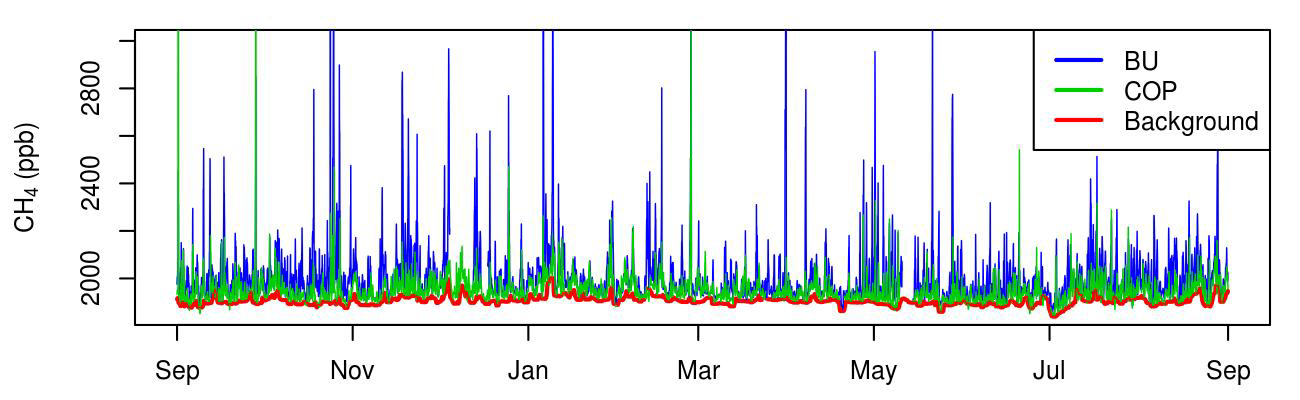
CMS: Atmospheric Methane Concentrations and Prior Emissions, Boston, MA, 2012-2014
National Aeronautics and Space Administration —
This data set provides average hourly measured, modeled enhancements, and background methane (CH4) concentrations, atmospheric ethane (C2H6) measurements, prior CH4... -
Federal
NACP MCI: CO2 Emissions Inventory, Upper Midwest Region, USA., 2007
National Aeronautics and Space Administration —
This data set provides a bottom-up CO2 emissions inventory for the mid-continent region of the United States for the year 2007. The study was undertaken as part of... -
Federal
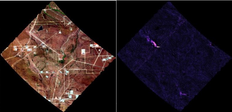
AVIRIS-3 L2B Greenhouse Gas Enhancements, Facility Instrument Collection
National Aeronautics and Space Administration —
This dataset contains Level 2B (L2b) enhancements of greenhouse gasses (GHG) derived from imagery collected by the Airborne Visible / Infrared Imaging Spectrometer-3... -
Federal
S-MODE MASS Level 1 Visible Imagery Version 1
National Aeronautics and Space Administration —
This dataset contains airborne visible imagery from the Sub-Mesoscale Ocean Dynamics Experiment (S-MODE) during a pilot campaign conducted approximately 300 km... -
Federal
Anthropogenic Carbon Emission System, 2012-2017, Version 2
National Aeronautics and Space Administration —
This dataset provides estimates of hourly carbon dioxide (CO2) emissions from the combustion of fossil fuels at 1-km resolution for the coterminous United States... -
Federal
Ice Draft and Ice Velocity Data in the Beaufort Sea, 1990-2003, Version 1
National Aeronautics and Space Administration —
This data set provides measurement of sea ice draft (m) and the movement of sea ice (cm/s) over the continental shelf of the Eastern Beaufort Sea. The data set spans... -
Federal
GPM GROUND VALIDATION DUAL-FREQUENCY DUAL-POLARIZED DOPPLER RADAR (D3R) IFLOODS
National Aeronautics and Space Administration —
The GPM Ground Validation Dual-frequency Dual-polarized Doppler Radar (D3R) IFloodS dataset contains radar reflectivity and doppler velocity measurements from the... -
Federal
MOOSE NASA G-3 Aircraft GEO-CAPE Airborne Simulator (GCAS) Remotely Sensed Data
National Aeronautics and Space Administration —
MOOSE_AircraftRemoteSensing_NASA-G3_GCAS_Data contains remotely sensed data collected by the GEOstationary Coastal and Air Pollution Events (GEO-CAPE) Airborne... -
Federal
Measurement of Air Pollution from Satellites (MAPS) Space Radar Laboratory - 1 (SRL1) Carbon Monoxide Second by Second data
National Aeronautics and Space Administration —
MAPS Overview The MAPS experiment measures the global distribution of carbon monoxide (CO) mixing ratios in the free troposphere. Because of MAPS' previous flights on...
172 datasets found for "industry"