
-
Federal
TES/Aura L2 Ancillary Special Observation Product V007
National Aeronautics and Space Administration —
TL2ANCS_7 is the Tropospheric Emission Spectrometer (TES)/Aura Level 2 Ancillary Special Observation Product Version 7 data product. TES was an instrument aboard... -
Federal
TNO AND CENTAUR COLORS V7.0
National Aeronautics and Space Administration —
This data set is intended to include published broadband colors of centaurs and Transneptunian Objects (TNOs) published through April 2010. It supersedes all versions... -
Federal
SDO/EVE Level 3 Version 8 Data
National Aeronautics and Space Administration —
EVE level 3 data files were created at the Laboratory for Atmospheric and Space Physics in Boulder, Colorado for the NASA Solar Dynamics Observatory (SDO) Extreme... -
Federal
Global Cyclone Proportional Economic Loss Risk Deciles
National Aeronautics and Space Administration —
The Global Cyclone Proportional Economic Loss Risk Deciles is a 2.5 minute grid of cyclone hazard economic loss as proportions of Gross Domestic Product (GDP) per... -
Federal
X-Ray Selected High-z AGN Catalog
National Aeronautics and Space Administration —
This table contains the results from an analysis of the largest high-redshift (z > 3) X-ray-selected active galactic nucleus (AGN) sample to date, combining the... -
Federal
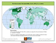
2002 Environmental Sustainability Index (ESI)
National Aeronautics and Space Administration —
The 2002 Environmental Sustainability Index (ESI) measures overall progress toward environmental sustainability for 142 countries based on environmental systems,... -
Federal
LISTOS New Haven Ground Site Data
National Aeronautics and Space Administration —
LISTOS_Ground_NewHaven_Data is the Long Island Sound Tropospheric Ozone Study (LISTOS) ground site data collected at the New Haven ground site during the LISTOS field... -
Federal
VIIRS/JPSS1 Active Fires 6-Min L2 Swath 375m NRT
National Aeronautics and Space Administration —
The VJ114IMG_NRT is a Near Real Time (NRT) NOAA-20 (formally JPSS-1) /VIIRS 375 m active fire detection data product. Compared to other coarser resolution (≥1km)... -
Federal
SWOT Level 2 Lake Single-Pass Vector Data Product, Version 2.0
National Aeronautics and Space Administration —
The SWOT Level 2 Lake Single-Pass Vector Data Product from the Surface Water Ocean Topography (SWOT) mission provides water surface elevation, area, storage change... -
Federal
TERRA MODIS High Resolution Level 3 daily aerosol data, 0.1x0.1 degree grid Version 001 (AER_DBDT_D10KM_L3_MODIS_TERRA) at GES DISC
National Aeronautics and Space Administration —
This High-Resolution (0.1 x 0.1 degree) Level 3 daily Aerosol Optical Depth (AOD) product is generated by combining two Moderate Resolution Imaging Spectroradiometer... -
Federal
CAMP2Ex Miscellaneous Data
National Aeronautics and Space Administration —
CAMP2Ex_Miscellaneous_Data are miscellaneous data (satellite, model, analysis, merge data, etc.) collected during the Clouds, Aerosol and Monsoon Processes-... -
Federal
CERES and GEO-Enhanced TOA, Within-Atmosphere and Surface Fluxes, Clouds and Aerosols Monthly-Averaged 1-Hourly Terra-Aqua-NOAA20 Edition4B
National Aeronautics and Space Administration —
CER_SYN1deg-MHour_Terra-Aqua-NOAA20_Edition4B is the Clouds and the Earth's Radiant Energy System (CERES) and geostationary (GEO)-Enhanced Top-of-Atmosphere (TOA),... -
Federal
Gridded Population of the World, Version 4 (GPWv4): Data Quality Indicators, Revision 11
National Aeronautics and Space Administration —
The Gridded Population of the World, Version 4 (GPWv4): Data Quality Indicators, Revision 11 consists of three data layers created to provide context for the... -
Federal
X-ray Micro-Tomography (micro-CT)
National Aeronautics and Space Administration —
X-ray micro-tomography (micro-CT) is a non-destructive imaging technique that provides resolution of material microstructures in three dimensions at scales from... -
Federal
2014 Environmental Performance Index (EPI)
National Aeronautics and Space Administration —
The 2014 Environmental Performance Index (EPI) ranks 178 countries on 20 performance indicators in the following 9 policy categories: health impacts, air quality,... -
Federal
CORONA Satellite Photographs from the U.S. Geological Survey
National Aeronautics and Space Administration —
The first generation of U.S. photo intelligence satellites collected more than 860,000 images of the Earth’s surface between 1960 and 1972. The classified military... -
Federal
Global Rural-Urban Mapping Project, Version 1 (GRUMPv1): Urban Extents Grid
National Aeronautics and Space Administration —
The Global Rural-Urban Mapping Project, Version 1 (GRUMPv1): Urban Extents Grid distinguishes urban and rural areas based on a combination of population counts... -
Federal
SRTM Water Body Data
National Aeronautics and Space Administration —
The SRTM Water Body Data files are a by-product of the data editing performed by the National Geospatial-Intelligence Agency (NGA) to produce the finished SRTM... -
Federal
2005 Environmental Sustainability Index (ESI)
National Aeronautics and Space Administration —
The 2005 Environmental Sustainability Index (ESI) is a measure of overall progress towards environmental sustainability, developed for 146 countries. The index... -
Federal
Prognostics Of Power Mosfets Under Thermal Stress Accelerated Aging Using Data-Driven And Model-Based Methodologies
National Aeronautics and Space Administration —
An approach for predicting remaining useful life of power MOSFETs (metal oxide field effect transistor) devices has been developed. Power MOSFETs are semiconductor...

Official websites use .gov
A
.gov website belongs to an official government
organization in the United States.
Secure .gov websites use HTTPS
A
lock (
) or https:// means you’ve safely connected to
the .gov website. Share sensitive information only on official,
secure websites.