
-
Federal
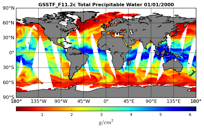
Goddard Satellite-Based Surface Turbulent Fluxes, 1x1 deg Daily Grid, Satellite F11 V2c (GSSTF_F11) at GES DISC
National Aeronautics and Space Administration —
These data are part of the Goddard Satellite-based Surface Turbulent Fluxes Version-2c (GSSTF 2c) Dataset recently produced through a MEaSURES funded project led by... -
Federal
Seasoar CTD data for the SPURS-1 N. Atlantic field campaign
National Aeronautics and Space Administration —
The SPURS (Salinity Processes in the Upper Ocean Regional Study) project is an oceanographic process study and associated field program that aim to elucidate key... -
Federal
Seaglider CTD data for the SPURS-1 N. Atlantic field campaign
National Aeronautics and Space Administration —
The SPURS (Salinity Processes in the Upper Ocean Regional Study) project is an oceanographic process study and associated field program that aim to elucidate key... -
Federal
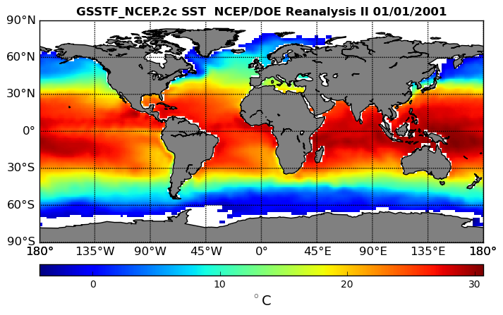
NCEP/DOE Reanalysis II in HDF-EOS5, for GSSTF2c, 1x1 deg Daily grid V2c (GSSTF_NCEP) at GES DISC
National Aeronautics and Space Administration —
These data are the Goddard Satellite-based Surface Turbulent Fluxes Version-2c (GSSTF2c) Dataset recently produced through a MEaSURES funded project led by Dr. Chung-... -
Federal
VIIRS/JPSS1 Water Reservoir Monthly L3 Global V002
National Aeronautics and Space Administration —
The NOAA-20 Visible Infrared Imaging Radiometer Suite (VIIRS) Water Reservoir Monthly Level 3 (L3) Global (VJ128C3) Version 2 product provides current data for 151... -
Federal
SPURS-1 research vessel Underway-CTD trajectory profile data for N. Atlantic Endeavor and Knorr cruises
National Aeronautics and Space Administration —
The SPURS (Salinity Processes in the Upper Ocean Regional Study) project is an oceanographic process study and associated field program that aim to elucidate key... -
Federal
SPURS-1 shipboard Acoustic Doppler Current Profiler data for N. Atlantic Endeavor and Knorr cruises
National Aeronautics and Space Administration —
The SPURS (Salinity Processes in the Upper Ocean Regional Study) project is an oceanographic process study and associated field program that aim to elucidate key... -
Federal
SPURS-1 research vessel Meteorological series data for N. Atlantic Endeavor cruises
National Aeronautics and Space Administration —
The SPURS (Salinity Processes in the Upper Ocean Regional Study) project is an oceanographic process study and associated field program that aim to elucidate key... -
Federal
SPURS-1 research vessel CTD profile data for N. Atlantic cruises
National Aeronautics and Space Administration —
The SPURS (Salinity Processes in the Upper Ocean Regional Study) project is an oceanographic process study and associated field program that aim to elucidate key... -
Federal
Forest-BGC Model (OTTER)
National Aeronautics and Space Administration —
Steve Running's Forest-BGC Model -
Federal
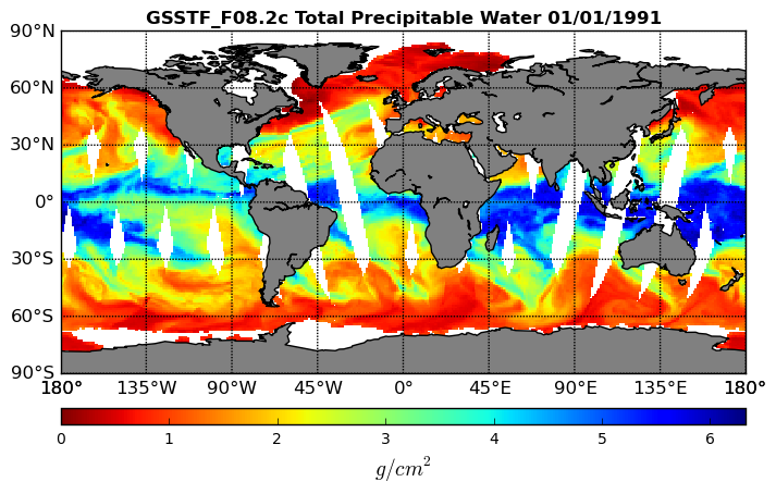
Goddard Satellite-Based Surface Turbulent Fluxes, 1x1 deg Daily Grid, Satellite F08 V2c (GSSTF_F08) at GES DISC
National Aeronautics and Space Administration —
These data are part of the Goddard Satellite-based Surface Turbulent Fluxes Version-2c (GSSTF 2c) Dataset recently produced through a MEaSURES funded project led by... -
Federal
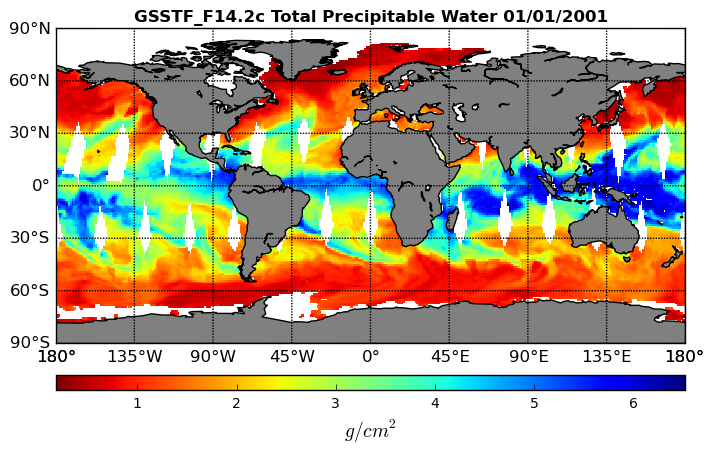
Goddard Satellite-Based Surface Turbulent Fluxes, 0.25 x 0.25 deg, Daily Grid F14 V3 (GSSTF_F14) at GES DISC
National Aeronautics and Space Administration —
These data are part of the Goddard Satellite-based Surface Turbulent Fluxes Version 3 (GSSTF3) Dataset recently produced through a MEaSURES funded project led by Dr.... -
Federal
ECOSTRESS Evaporative Stress Index dis-ALEXI USDA Daily L4 Global 30m V001
National Aeronautics and Space Administration —
The ECOsystem Spaceborne Thermal Radiometer Experiment on Space Station (ECOSTRESS) mission measures the temperature of plants to better understand how much water... -
Federal
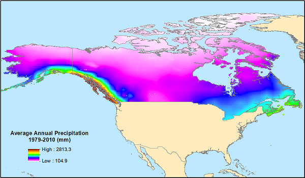
ABoVE: Monthly Hydrological Fluxes for Canada and Alaska, 1979-2018
National Aeronautics and Space Administration —
This dataset provides modeled estimates of monthly hydrological fluxes at 0.25-degree resolution over Alaska and Canada for the years 1979-2018. The estimates were... -
Federal
Arctic Tundra Flux Study in the Kuparuk River Basin (Alaska), 1994-1996
National Aeronautics and Space Administration —
CO2 and water vapor fluxes and ecosystem characteristics were measured at 24 sites along a 317-km transect from the Arctic coast to the latitudinal treeline in Alaska... -
Federal
Ecomapper data for the SPURS-1 N. Atlantic field campaign
National Aeronautics and Space Administration —
The SPURS (Salinity Processes in the Upper Ocean Regional Study) project is an oceanographic process study and associated field program that aim to elucidate key... -
Federal
CAMEX-4 DC-8 NEVZOROV TOTAL CONDENSED WATER CONTENT SENSOR V1
National Aeronautics and Space Administration —
The CAMEX-4 DC-8 Nevzorov Total Condensed Water Content Sensor dataset was collected by the Nevzorov total condensed water content sensor which was used to measure... -
Federal
BOREAS RSS-08 BIOME-BGC Model Simulations at Tower Flux Sites in 1994
National Aeronautics and Space Administration —
BIOME-BGC is a general ecosystem process model designed to simulate biogeochemical and hydrologic processes across multiple scales (Running and Hunt, 1993). In this... -
Federal
BOREAS HYD-08 1994 Gravimetric Moss Moisture Data
National Aeronautics and Space Administration —
The BOREAS HYD-08 team made measurements of surface hydrological processes that were collected at the NSA OBS Tower Flux site in 1994 and at Joey Lake, Manitoba, to... -
Federal
BOREAS HYD-08 1996 Gravimetric Moss Moisture Data
National Aeronautics and Space Administration —
The BOREAS HYD-08 team made measurements of surface hydrological processes that were collected at the SSA-OBS Tower Flux site in 1996 to support its research into...

Official websites use .gov
A
.gov website belongs to an official government
organization in the United States.
Secure .gov websites use HTTPS
A
lock (
) or https:// means you’ve safely connected to
the .gov website. Share sensitive information only on official,
secure websites.