

95 datasets found for "Infrastructure"
-
Federal
Randolph Glacier Inventory - A Dataset of Global Glacier Outlines, Version 1
National Aeronautics and Space Administration —
The Randolph Glacier Inventory (RGI) is a global set of glacier outlines; it is intended as a snapshot of the world’s glaciers. This data set provides a single... -
Federal
Northern and Mid-Latitude Soil Database, Version 1, R1
National Aeronautics and Space Administration —
The U.S. Department of Agriculture, Agriculture and Agri-Food Canada, the Russian Academy of Agricultural Sciences, the University of Copenhagen Institute of... -
Federal
West Africa Coastal Vulnerability Mapping: Subset of JRC Map of Accessibility
National Aeronautics and Space Administration —
The West Africa Coastal Vulnerability Mapping: Subset of JRC Map of Accessibility data set is a 30 arc-second raster of travel time to major cities in West Africa... -
Federal
Networked Instrumentation Element
National Aeronautics and Space Administration —
Armstrong researchers have developed a networked instrumentation system that connects modern experimental payloads to existing analog and digital communications... -
Federal
Planning to Explore: Using a Coordinated Multisource Infrastructure to Overcome Present and Future Space Flight Planning Challenges
National Aeronautics and Space Administration —
Few human endeavors present as much of a planning and scheduling challenge as space flight, particularly manned space flight. Just on the operational side of it,... -
Federal
GRIP METEOSAT SECOND GENERATION (MSG) IMAGE DATA V1
National Aeronautics and Space Administration —
The GRIP Meteosat Second Generation (MSG) Image Data was collected during the Genesis and Rapid Intensification Processes (GRIP) experiment from August 15, 2010 to... -
Federal
GPM GROUND VALIDATION AUTONOMOUS PARSIVEL UNIT (APU) NSSTC V1
National Aeronautics and Space Administration —
The GPM Ground Validation Autonomous Parsivel Unit (APU) NSSTC dataset was collected by the Autonomous Parsivel Unit (APU), which is an optical disdrometer based on... -
Federal
Global Multihazard Frequency and Distribution
National Aeronautics and Space Administration —
The Global Multihazard Frequency and Distribution is a 2.5 minute grid presenting a simple multihazard index based solely on summated single-hazard decile values. The... -
Federal
General Mission Analysis Tool Project
National Aeronautics and Space Administration —
Overview GMAT is a feature rich system containing high fidelity space system models, optimization and targeting,built in scripting and programming infrastructure, and... -
Federal
DSCOVR EPIC Level 2 Cloud Version 03
National Aeronautics and Space Administration —
DSCOVR_EPIC_L2_CLOUD_03 is the Deep Space Climate Observatory (DSCOVR) Earth Polychromatic Imaging Camera (EPIC) Level 2 Cloud version 03 data product. The EPIC Level... -
Federal
AMSR-E/Aqua Daily L3 Global Snow Water Equivalent EASE-Grids V002
National Aeronautics and Space Administration —
These Level-3 Snow Water Equivalent (SWE) data sets contain SWE data and quality assurance flags mapped to Northern and Southern Hemisphere 25 km Equal-Area Scalable... -
Federal
LBA-ECO LC-24 Historical Roads of the Legal Amazon: 1968-1993
National Aeronautics and Space Administration —
Understanding the impact of road investments on deforestation is part of a complete evaluation of the expansion of infrastructure for development.We find evidence of... -
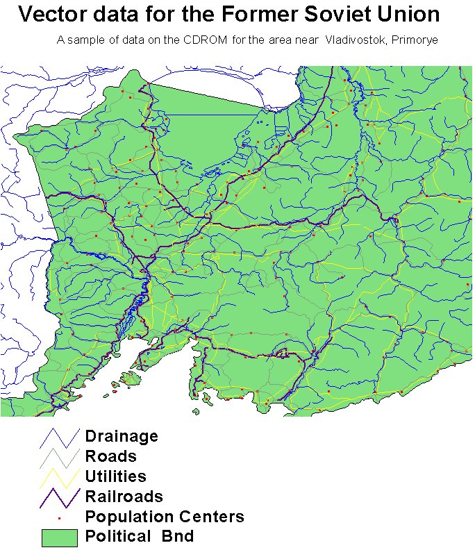
Federal
RLC Selected Infrastructure Data for the Former Soviet Union, 1993
National Aeronautics and Space Administration —
This data set consists of roads, drainage, railroads, utilities, and population center information in readily usable vector format for the land area of the Former... -
Federal
RAMP AMM-1 SAR Image Mosaic of Antarctica, Version 2
National Aeronautics and Space Administration —
The mosaic provides a detailed look at ice sheet morphology, rock outcrops, research infrastructure, the coastline, and other features of Antarctica, as well as...
95 datasets found for "Infrastructure"