
-
Federal
SDG Indicator 11.2.1: Urban Access to Public Transport, 2023 Release
National Aeronautics and Space Administration —
The SDG Indicator 11.2.1: Urban Access to Public Transport, 2023 Release, part of the SDGI collection, measures the proportion of the population in a city that has... -
Federal
NASA Life Sciences Portal (NLSP)
National Aeronautics and Space Administration —
The NASA Life Sciences Portal (NLSP) is the data platform for accessing NASA's Life Sciences Data Archive (LSDA). The LSDA is an active archive that provides... -
Federal
SDG Indicator 7.1.1: Access to Electricity, 2023 Release
National Aeronautics and Space Administration —
The SDG Indicator 7.1.1: Access to Electricity, 2023 Release data set, part of the Sustainable Development Goal Indicators (SDGI) collection, measures the proportion... -
Federal
Fast Longwave And SHortwave Fluxes (FLASHflux) Clouds and Radiative Swath (SSF) TERRA-FM1 data in HDF Version 4A
National Aeronautics and Space Administration —
FLASH_SSF_Terra-FM1-MODIS_Version4A is the Fast Longwave And Shortwave Radiative Fluxes (FLASHFlux) Clouds and Radiative Swath (SSF) TERRA-FM1 data in HDF Version 4A... -
Federal
The NASA Air Traffic Management Ontology (atmonto)
National Aeronautics and Space Administration —
The NASA ATM (Air Traffic Management) Ontology describes classes, properties, and relationships relevant to the domain of air traffic management, and represents... -
Federal
SMAP L3 Radiometer Global Daily 36 km EASE-Grid Soil Moisture V009
National Aeronautics and Space Administration —
This Level-3 (L3) soil moisture product provides a composite of daily estimates of global land surface conditions retrieved by the Soil Moisture Active Passive (SMAP)... -
Federal
TNO AND CENTAUR COLORS V9.0
National Aeronautics and Space Administration —
This data set is intended to include published broadband colors of centaurs and Transneptunian Objects (TNOs) published through March 2013. It includes some comets... -
Federal
VIIRS/NPP Surface Reflectance Daily L3 Global 0.05 Deg CMG V001
National Aeronautics and Space Administration —
The Visible Infrared Imaging Radiometer Suite (VIIRS) (https://lpdaac.usgs.gov/dataset_discovery/viirs) daily surface reflectance Climate Modeling Grid (VNP09CMG)... -
Federal
Global Gridded Relative Deprivation Index (GRDI), Version 1
National Aeronautics and Space Administration —
The Global Gridded Relative Deprivation Index (GRDI), Version 1 (GRDIv1) data set characterizes the relative levels of multidimensional deprivation and poverty in... -
Federal
Gazetteer of Planetary Nomenclature: Uranian System: Ariel
National Aeronautics and Space Administration —
These images display several of Uranus's moons approved by the International Astronomical Union (IAU). -
Federal
Effects of Space Flight on Inflammasome Activation in the Brain of Mice (Brain, Western Blot and ECLIA)
National Aeronautics and Space Administration —
Space exploration exposes astronauts to stressors that alter the immune response, rendering them vulnerable to infections and diseases. In this study, we aimed to... -
Federal
2010 Environmental Performance Index (EPI)
National Aeronautics and Space Administration —
The 2010 Environmental Performance Index (EPI) ranks 163 countries on environmental performance based on twenty-five indicators grouped within ten core policy... -
Federal
Archive of Census Related Products (ACRP): 1990 Census Block Statistics
National Aeronautics and Space Administration —
The 1990 Census Block Statistics portion of the Archive of Census Related Products (ACRP) contains population and housing data from the U.S. Census Bureau's 1990... -
Federal
Sounder SIPS: Suomi NPP CrIMSS Level 3 Comprehensive Quality Control Gridded Daily CLIMCAPS Full Spectral Resolution V2 (SNDRSNIML3CDCCP) at GES DISC
National Aeronautics and Space Administration —
WARNING: To users of the derived product “co_mmr_midtrop” (carbon monoxide mass mixing ratio to dry air [kg/kg] at ~500 hPa). This variable has a significant bias due... -
Federal
SARP 2019 Data
National Aeronautics and Space Administration —
SARP_2019_Data is the data collected onboard the NASA DC-8 aircraft during the 2019 deployment of the Student Airborne Research Program (SARP) mission. Data... -
Federal
Radiant Temp. Multiangle Data (FIFE)
National Aeronautics and Space Administration —
The Surface Temperatures Measured at Multiple Angles Data Set was collected at two locations within the northwest quadrant of the FIFE study area during July and... -
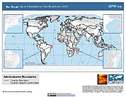
Federal
Gridded Population of the World, Version 3 (GPWv3): Subnational Administrative Boundaries
National Aeronautics and Space Administration —
The Gridded Population of the World, Version 3 (GPWv3): Subnational Administrative Boundaries are the basis of the population data products in GPWv3. Due to copyright... -
Federal
SnowEx23 Bonanza Creek Experimental Forest Terrestrial Lidar Scans Raw V001
National Aeronautics and Space Administration —
This data set contains unprocessed point cloud data created from terrestrial lidar scans (TLS) collected during the SnowEx 2023 campaign from the Bonanza Creek... -
Federal
Morphological Galaxy Catalog
National Aeronautics and Space Administration —
The MCG database contains the "Morphological Catalogue of Galaxies," a compilation of information for approximately 34,000 galaxies found and examined on the Palomar...

Official websites use .gov
A
.gov website belongs to an official government
organization in the United States.
Secure .gov websites use HTTPS
A
lock (
) or https:// means you’ve safely connected to
the .gov website. Share sensitive information only on official,
secure websites.