
-
Federal
NASA Landsat Data Collection
National Aeronautics and Space Administration —
The NASA Landsat Data Collection (NLDC) is a compilation of Landsat multispectral scanner (MSS) scenes and Landsat thematic mapper (TM) scenes. This compilation of... -
Federal
Global Annual PM2.5 Grids from MODIS, MISR and SeaWiFS Aerosol Optical Depth (AOD), 1998-2019, V4.GL.03 NGDA
National Aeronautics and Space Administration —
The Global Annual PM2.5 Grids from MODIS, MISR and SeaWiFS Aerosol Optical Depth (AOD), 1998-2019, V4.GL.03 consists of annual concentrations (micrograms per cubic... -
Federal
PHM 2008 Challenge
National Aeronautics and Space Administration —
This dataset describes the degradation of an aircraft engine. The dataset was used for the prognostics challenge competition at the International Conference on... -
Federal
Multiple Kernel Learning for Heterogeneous Anomaly Detection: Algorithm and Aviation Safety Case Study
National Aeronautics and Space Administration —
The world-wide aviation system is one of the most complex dynamical systems ever developed and is generating data at an extremely rapid rate. Most modern commercial... -
Federal
CALIPSO All-Sky Lidar L3 Data V1-30
National Aeronautics and Space Administration —
Cloud-Aerosol Lidar and Infrared Pathfinder Satellite Observations (CALIPSO) was launched on April 28, 2006 to study the impact of clouds and aerosols on the Earth’s... -
Federal
Physics of Failure Models for Capacitor Degradation in DC-DC Converters
National Aeronautics and Space Administration —
This paper proposes a combined energy-based model with an empirical physics of failure model for degradation analysis and prognosis of electrolytic capacitors in DC-... -
Federal
OMI/Aura Sulphur Dioxide (SO2) Total Column 1-orbit L2 Swath 13x24 km V003 NRT
National Aeronautics and Space Administration —
The Ozone Monitoring Instrument (OMI) was launched aboard the EOS-Aura satellite on July 15, 2004 (1:38 pm equator crossing time, ascending mode). OMI with its 2600... -
Federal
CALIPSO Lidar Level 3 Tropospheric Aerosol Profiles, Cloud Free Data, Standard V4-20
National Aeronautics and Space Administration —
CAL_LID_L3_Tropospheric_APro_CloudFree-Standard-V4-20 is the Cloud-Aerosol Lidar and Infrared Pathfinder Satellite Observation (CALIPSO) Lidar Level 3 Tropospheric... -
Federal
West Africa Coastal Vulnerability Mapping: Gridded Subset of Sub-national Poverty and Extreme Poverty Prevalence
National Aeronautics and Space Administration —
The West Africa Coastal Vulnerability Mapping: Gridded Subset of Sub-national Poverty and Extreme Poverty Prevalence represents the HarvestChoice Subnational Poverty... -
Federal
Global One-Eighth Degree Population Base Year and Projection Grids Based on the Shared Socioeconomic Pathways, Revision 01
National Aeronautics and Space Administration —
The Global One-Eighth Degree Population Base Year and Projection Grids Based on the Shared Socioeconomic Pathways, Revision 01, data set consists of global urban,... -
Federal
GLAS/ICESat L2 Global Planetary Boundary Layer and Elevated Aerosol Layer Heights (HDF5) V033
National Aeronautics and Space Administration —
GLAH08 Level-2 planetary boundary layer (PBL) and elevated aerosol layer heights data contains PBL heights, ground detection heights, and top and bottom heights of... -
Federal
TRMM Radar Rainfall Statistics L3 1 month (5 x 5) and (0.5 x 0.5) degree V7 (TRMM_3A25) at GES DISC
National Aeronautics and Space Administration —
The new version of these data is in GPM-like format (consistent with the GPM Dual-frequency Radar data format), and can be found under the name GPM_3PR. This product... -
Federal
China Dimensions Data Collection: Bibliography of Chinese Administrative Geography
National Aeronautics and Space Administration —
The Bibliography of Chinese Administrative Geography is a historical collection of bibliographic information on 75 published books describing the administrative... -
Federal
AMSR-E/AMSR2 Unified L3 Daily 12.5 km Brightness Temperatures, Sea Ice Concentration, Motion & Snow Depth Polar Grids V001
National Aeronautics and Space Administration —
This data set reports average daily horizontally and vertically polarized brightness temperatures; sea ice concentrations; and snow depths over sea ice on 12.5 km... -
Federal
GEDI L4A Footprint Level Aboveground Biomass Density, Version 1
National Aeronautics and Space Administration —
This dataset contains Global Ecosystem Dynamics Investigation (GEDI) Level 4A (L4A) predictions of the aboveground biomass density (AGBD; in Mg/ha) and estimates of... -
Federal
METEOROID ORBITS V1.0
National Aeronautics and Space Administration —
This data set contains meteoroid orbits from photographic, TV system, and radar meteoroid surveys collected from the International Astronomical Union Meteor Data... -
Federal
Amazon Forest Structure from Airborne Lidar, ED2 Initial Condition Files, 2016
National Aeronautics and Space Administration —
This dataset provides initial condition files for initializing the Ecosystem Demography Model (ED2). This dataset holds regional forest structure characteristics... -
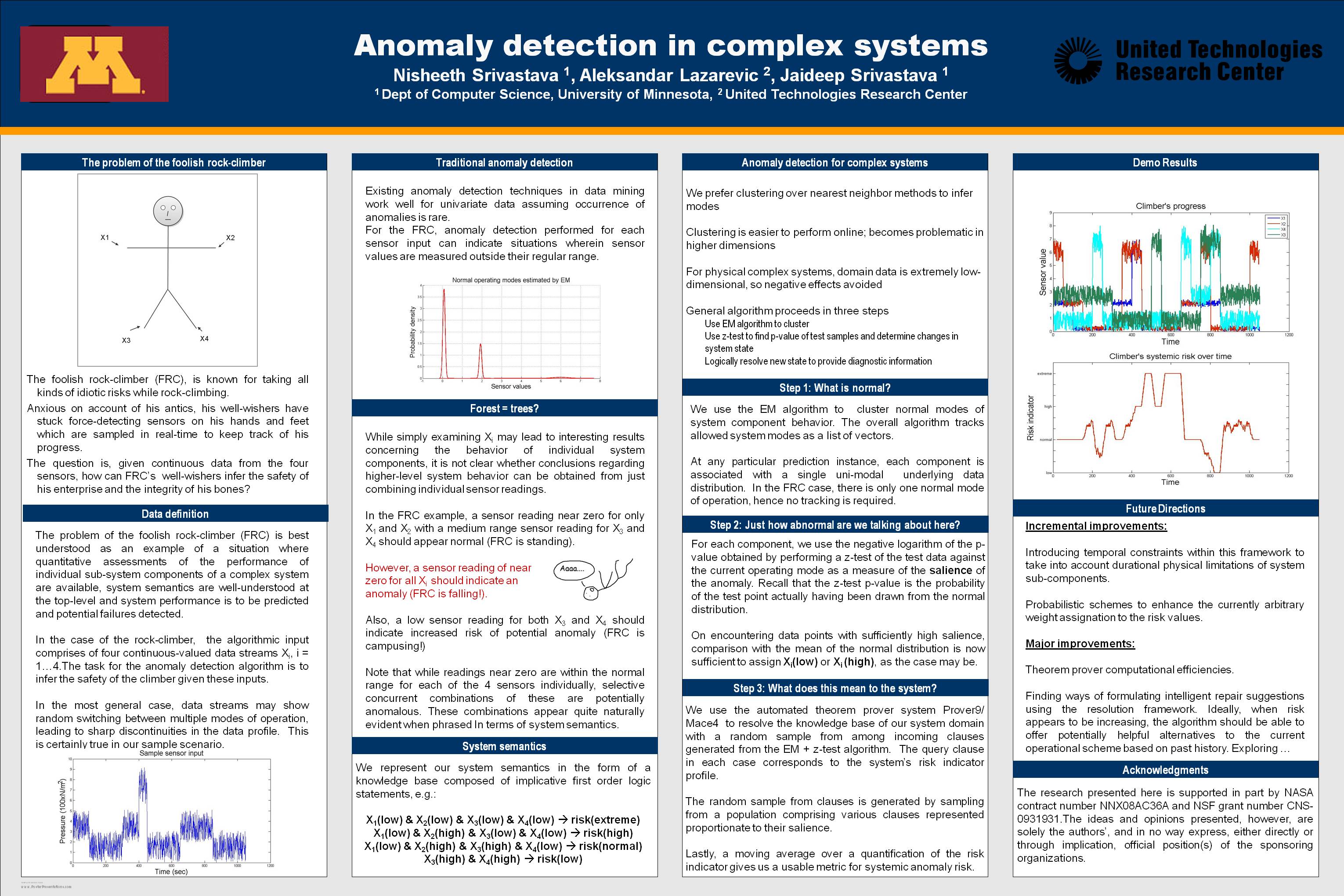
Federal
Anomaly Detection for Complex Systems
National Aeronautics and Space Administration —
In performance maintenance in large, complex systems, sensor information from sub-components tends to be readily available, and can be used to make predictions about... -
Federal
Last of the Wild Project, Version 2, 2005 (LWP-2): Global Human Influence Index (HII) Dataset (Geographic)
National Aeronautics and Space Administration —
The Global Human Influence Index Dataset of the Last of the Wild Project, Version 2, 2005 (LWP-2) is a global dataset of 1-kilometer grid cells, created from nine... -
Federal
Space Shuttle Main Propulsion System Anomaly Detection: A Case Study
National Aeronautics and Space Administration —
The space shuttle main engine (SSME) is part of the Main Propnlsion System (MPS) which is an extremely complex system containing several sub-systems and components,...

Official websites use .gov
A
.gov website belongs to an official government
organization in the United States.
Secure .gov websites use HTTPS
A
lock (
) or https:// means you’ve safely connected to
the .gov website. Share sensitive information only on official,
secure websites.