
-
Federal
MODIS/Terra+Aqua BRDF/Albedo Black Sky Albedo VIS Daily L3 Global 30ArcSec CMG V061
National Aeronautics and Space Administration —
The MCD43D49 Version 6.1 Bidirectional Reflectance Distribution Function and Albedo (BRDF/Albedo) Black-Sky Albedo dataset is produced daily using 16 days of Terra... -
Federal
MODIS/Terra+Aqua BRDF/Albedo Parameter1 Band4 Daily L3 Global 30ArcSec CMG V061
National Aeronautics and Space Administration —
The MCD43D10 Version 6.1 Bidirectional Reflectance Distribution Function and Albedo (BRDF/Albedo) Model Parameter dataset is produced daily using 16 days of Terra and... -
Federal
MASTER: Airborne Science, California-Nevada, August, 2004
National Aeronautics and Space Administration —
This dataset includes Level 1B (L1B) data products from the MODIS/ASTER Airborne Simulator (MASTER) instrument. The spectral data were collected during one flight... -
Federal
CERES and GEO-Enhanced TOA, Within-Atmosphere and Surface Fluxes, Clouds and Aerosols Monthly-Averaged 1-Hourly Terra-Aqua Edition4A
National Aeronautics and Space Administration —
CER_SYN1deg-MHour_Terra-Aqua-MODIS_Edition4A is the Clouds and the Earth's Radiant Energy System (CERES) and geostationary (GEO)-Enhanced Top-of-Atmosphere (TOA),... -
Federal
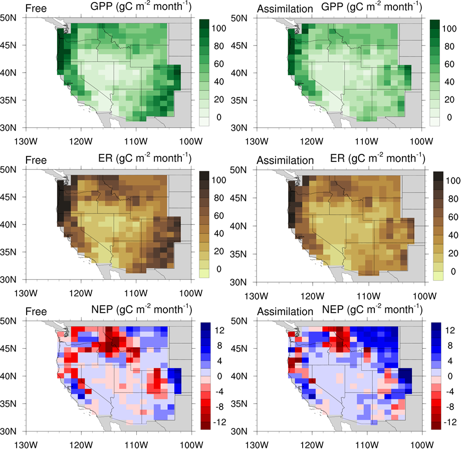
CLM5-DART Regional Carbon Fluxes and Stocks over the Western US, 1998-2010
National Aeronautics and Space Administration —
This dataset provides monthly estimates of biomass stocks and land-atmosphere carbon exchange across the western United States at 0.95 degrees longitude x 1.25... -
Federal
BOREAS TE-18 Landsat TM Physical Classification Image of the NSA
National Aeronautics and Space Administration —
The objective of this classification is to provide the BOREAS investigators with a data product that characterizes the land cover of the NSA. A Landsat-5 TM image... -
Federal
Active-Layer and Permafrost Temperatures, Soendre Stroemfjord, Greenland, Version 1
National Aeronautics and Space Administration —
This data set contains active-layer and permafrost temperatures from two stations in Soendre Stroemfjord, Greenland. Snow depth and snow extent were also recorded.... -
Federal
SAGE-SMC IRAC Epoch 0, Epoch 1, and Epoch 2 Catalog
National Aeronautics and Space Administration —
The SAGE-SMC pro ject is a Cycle 4 legacy program on the Spitzer Space Telescope, entitled, SAGE-SMC: Surveying the Agents of Galaxy Evolution in the Tidally-... -
Federal
BARREL 2O X-ray Spectrometer (FSPC) Bremsstrahlung X-ray Spectrum Fast Time Resolution, Level 2, 0.05 s Data
National Aeronautics and Space Administration —
FSPC: Six channels of fast time resolution, 50 ms, Bremsstrahlung X-ray spectra detected with a NaI Scintillator. Each channel is separated in its own variable:... -
Federal
BARREL 1T X-ray Spectrometer (SSPC) Bremsstrahlung X-ray Spectrum Slow Time Resolution, Level 2, 32 s Data
National Aeronautics and Space Administration —
SSPC: 256 channels of slow time resolution, 32 s, Bremsstrahlung X-ray spectra detected with a NaI Scintillator. The nominal energy range covered by the 256 channels... -
Federal
BARREL 1U Rate Counter (RCNT) NaI Scintillator Diagnostics, Level 2, 4 s Data
National Aeronautics and Space Administration —
This data product consists of measurements from rate counters. The rate count data are diagnostic fields, have uncalibrated energy ranges, and wrap near or above... -
Federal
Candida albicans response to spaceflight (NASA STS-115)
National Aeronautics and Space Administration —
This study presents the first global transcriptional profiling and phenotypic characterization of the major human opportunistic fungal pathogen, Candida albicans,... -
Federal
ECCO Ocean Bottom Pressure - Daily Mean 0.5 Degree (Version 4 Release 4)
National Aeronautics and Space Administration —
This dataset contains daily-averaged ocean bottom pressure interpolated to a regular 0.5-degree grid from the ECCO Version 4 revision 4 (V4r4) ocean and sea-ice state... -
Federal
GPM GROUND VALIDATION ACHIEVE W-BAND CLOUD RADAR IPHEX V1
National Aeronautics and Space Administration —
The GPM Ground Validation ACHIEVE W-band Cloud Radar IPHEx dataset consists of cloud and light precipitation radar observations gathered during the Global... -
Federal
Small Magellanic Cloud XMM-Newton Point Source Catalog
National Aeronautics and Space Administration —
The XMM-Newton survey of the Small Magellanic Cloud (SMC) yielded complete coverage of the bar and eastern wing in the 0.2-12.0 keV energy band. In addition to the... -
Federal
Chandra Large-Area Synoptic X-Ray Survey of Lockman Hole-NW
National Aeronautics and Space Administration —
This table contains the X-ray catalog and basic results from the wide-area, moderately deep Chandra Large Area Synoptic X-ray Survey (CLASXS) of the Lockman Hole-... -
Federal
Daneborg (DNB) Ground-based Vector Magnetic Field (L2) 20.0 s Data
National Aeronautics and Space Administration —
Daneborg, Greenland, Ground-based Vector Magnetic Field Level 2 Data, 20.0 s Time Resolution, Station Code: (DNB), Station Location: (GEO Latitude 74.3, Longitude... -
Federal
NOAA-20 VIIRS Level-3 Global Mapped Normalized Difference Vegetation Index Data, version R2022.0
National Aeronautics and Space Administration —
The Visible and Infrared Imager/Radiometer Suite (VIIRS) is a multi-disciplinary instrument that is being flown on the Joint Polar Satellite System (JPSS) series of... -
Federal
Sentinel-5P TROPOMI Radiance product band 2 (UV detector) L1B 5.5km x 3.5km V1 (S5P_L1B_RA_BD2_HiR) at GES DISC
National Aeronautics and Space Administration —
Starting from August 6th in 2019, Sentinel-5P TROPOMI along-track high spatial resolution (~5.5km at nadir) has been implemented.For data before August 6th of 2019,...

Official websites use .gov
A
.gov website belongs to an official government
organization in the United States.
Secure .gov websites use HTTPS
A
lock (
) or https:// means you’ve safely connected to
the .gov website. Share sensitive information only on official,
secure websites.