
-
Federal
LINKAGES: An Individual-based Forest Ecosystem Biogeochemistry Model
National Aeronautics and Space Administration —
This model product contains the source codes for version 1 of the individual-based forest ecosystem biogeochemistry model LINKAGES and two subsequent versions as well... -
Federal
SAFARI 2000 MODIS MOD05_L2 Water Vapor Data, Binary Format, for Southern Africa
National Aeronautics and Space Administration —
The Moderate Resolution Imaging Spectroradiometer (MODIS) precipitable water product consists of vertical column water-vapor amounts in centimeters (cm) at 1-km... -
Federal
ARC Code TI: ROBUS-2
National Aeronautics and Space Administration —
The ROBUS-2 Protocol Processor (RPP) is a custom-designed hardware component implementing the functionality of the ROBUS-2 fault-tolerant communication system. The... -
Federal
AERONET-OCEAN COLOR
National Aeronautics and Space Administration —
The Aerosol Robotic Network (AERONET), developed to sustain atmospheric studies at various scales with measurements from worldwide distributed autonomous sun-... -
Federal
ARC Code TI: X-Plane Communications Toolbox (XPC)
National Aeronautics and Space Administration —
The X-Plane Communications Toolbox (XPC) is an open source research tool used to interact with the commercial flight simulator software X-Plane. XPC allows users to... -
Federal
Tropical CPR identification data for Organization Metric
National Aeronautics and Space Administration —
There are three kinds of files are in one zip file. 1) Cloud-Precipitation (hybrid) regime information projected onto hourly IMERG precipitation data (Version Pr6x7... -
Federal
SORCE XPS Level 4 Solar Spectral Irradiance 0.1nm Res 5-Minute V012 (SOR4XPS5) at GES DISC
National Aeronautics and Space Administration —
The SORCE XPS Level 4 Solar Spectral Irradiance 0.1nm Res 5-Minute product (SOR4XPS5) contains modelled spectral extreme ultraviolet (XUV) irradiances based on... -
Federal
Global Food Security-support Analysis Data (GFSAD) Cropland Extent 2015 Africa 30 m V001
National Aeronautics and Space Administration —
The NASA Making Earth System Data Records for Use in Research Environments (MEaSUREs) Global Food Security-support Analysis Data (GFSAD) data product provides... -
Federal
Vegetation Species Reference (FIFE)
National Aeronautics and Space Administration —
The Konza Natural Research Area is a tallgrass prairie in a biologically heterogeneous environment that is rich in native plant species. Species composition is... -
Federal
Satellite Atmos. Correction Coef. (FIFE)
National Aeronautics and Space Administration —
The atmospheric effects on the transmitted and reflected solar radiation should be factored into the estimation of geophysical and biophysical parameters from... -
Federal
SAFARI 2000 Carbon in Live Vegetation, 0.5-Deg (Olson)
National Aeronautics and Space Administration —
This data set is a subset of Olson's Major World Ecosystem Complexes for southern Africa in ASCII GRID and binary image files formats. Olson's Major World Ecosystem... -
Federal
Walker Branch Watershed Vegetation Inventory, 1967-2006, R1
National Aeronautics and Space Administration —
This data set contains five data files, in comma-separated format (.csv), derived from the Walker Branch Watershed (WBW) vegetation inventory in eastern Tennessee.... -
Federal
TransCom 3: Seasonal CO2 Flux Estimates from Atmospheric Inversions (Level 2)
National Aeronautics and Space Administration —
This data set provides model outputs and seasonal mean CO2 fluxes from the Atmospheric Carbon Cycle Inversion Intercomparison (TransCom 3), Level 2 inversion... -
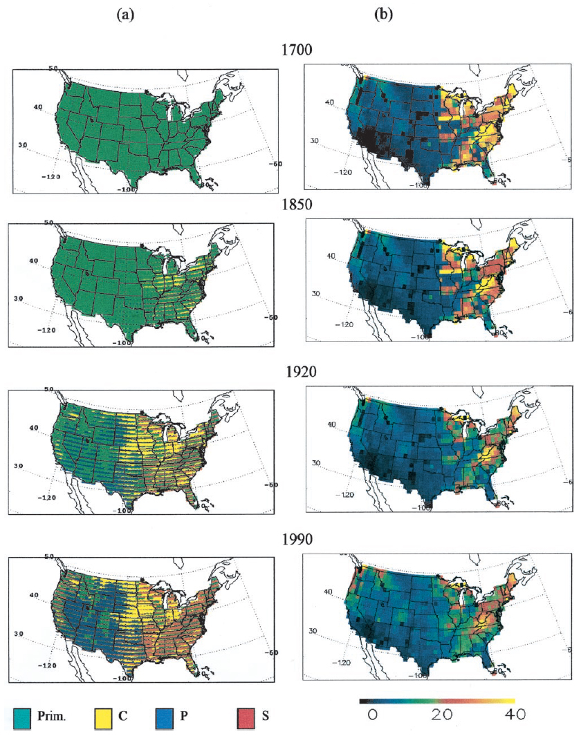
Federal
Ecosystem Demography Model: U.S. Ecosystem Carbon Stocks and Fluxes, 1700-1990
National Aeronautics and Space Administration —
This model product contains the source code for the Ecosystem Demography Model (ED version 1.0) as well as model input and output data files for the conterminous... -
Federal
Global Food Security-support Analysis Data (GFSAD) Cropland Extent 2010 North America product 30 m V001
National Aeronautics and Space Administration —
The NASA Making Earth System Data Records for Use in Research Environments (MEaSUREs) Global Food Security-support Analysis Data (GFSAD) data product provides... -
Federal
Delta-X: Matlab Model for Wax Lake Delta Land Accretion
National Aeronautics and Space Administration —
This dataset provides the Matlab sediment transport and land accretion model at Wax Lake Delta (WLD), Atchafalaya Basin, in coastal Louisiana. The data include the... -
Federal
ABoVE: Synthesis of Burned and Unburned Forest Site Data, AK and Canada, 1983-2016
National Aeronautics and Space Administration —
This dataset is a synthesis of field plot characterization data, derived above-ground and below-ground combusted carbon, and acquired Fire Weather Index (FWI) System... -
Federal
ABoVE/ASCENDS: Atmospheric Backscattering Coefficient Profiles from CO2 Sounder, 2017
National Aeronautics and Space Administration —
This dataset provides atmospheric backscattering coefficient profiles collected during Active Sensing of CO2 Emissions over Nights, Days, and Seasons (ASCENDS)... -
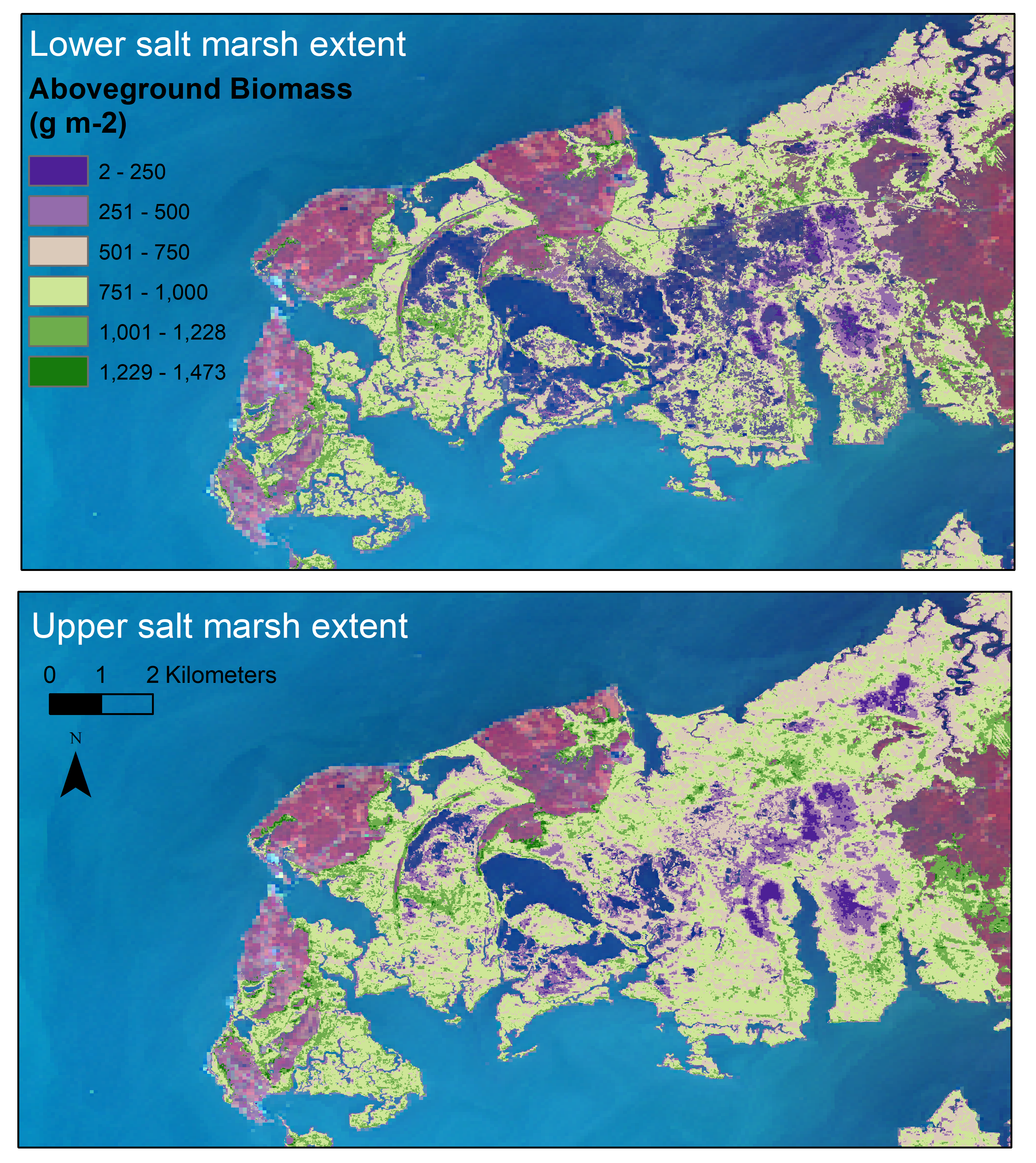
Federal
Aboveground Biomass Estimates for Salt Marsh for the Contiguous United States, 2020
National Aeronautics and Space Administration —
This dataset provides estimates of aboveground biomass (AGB) and salt marsh extent in the contiguous United States for 2020 and includes all coastal watersheds across... -
Federal
Arctic Vegetation Plots Legacy Project Barter Island and Point Barrow, Alaska, 1994
National Aeronautics and Space Administration —
This dataset provides vegetation cover and environmental plot and soil data collected at two U.S. Air Force sites at Barter Island (BI) and Point Barrow (B), on the...

Official websites use .gov
A
.gov website belongs to an official government
organization in the United States.
Secure .gov websites use HTTPS
A
lock (
) or https:// means you’ve safely connected to
the .gov website. Share sensitive information only on official,
secure websites.