

75 datasets found for "Natural Gas"
-
Federal
CAMP2Ex Miscellaneous Data
National Aeronautics and Space Administration —
CAMP2Ex_Miscellaneous_Data are miscellaneous data (satellite, model, analysis, merge data, etc.) collected during the Clouds, Aerosol and Monsoon Processes-... -
Federal
LISTOS Yale Coastal Ground Site Data
National Aeronautics and Space Administration —
LISTOS_Ground_YaleCoastal_Data is the Long Island Sound Tropospheric Ozone Study (LISTOS) ground site data collected at the Yale Coastal ground site during the LISTOS... -
Federal
LISTOS Outer Island Ground Site Data
National Aeronautics and Space Administration —
LISTOS_Ground_OuterIsland_Data is the Long Island Sound Tropospheric Ozone Study (LISTOS) ground site data collected at the Outer Island ground site during the LISTOS... -
Federal
LISTOS Hammonasset Ground Site Data
National Aeronautics and Space Administration —
LISTOS_Ground_Hammonasset_Data is the Long Island Sound Tropospheric Ozone Study (LISTOS) ground site data collected at the Hammonasset ground site during the LISTOS... -
Federal
LBA-ECO ND-07 Trace Gas Fluxes Under Multiple Land Uses, Brazil: 1999-2004
National Aeronautics and Space Administration —
This data set reports on soil-atmosphere fluxes of trace carbon dioxide, carbon monoxide, nitrous oxide, and nitric oxide (CO2, CO, N2O, NO) under various natural and... -
Federal
LISTOS NASA Aircraft Remote Sensing Data
National Aeronautics and Space Administration —
LISTOS_AircraftRemoteSensing_NASAAircraft_Data is the Long Island Sound Tropospheric Ozone Study (LISTOS) remote sensing data collected onboard the NASA aircraft... -
Federal
Tropical Ozone Transport Experiment – Vortex Ozone Transport Experiment (TOTE-VOTE) DC-8 In Situ Trace Gas Data
National Aeronautics and Space Administration —
TOTE-VOTE_TraceGas_AircraftInSitu_DC8_Data_1 is the in situ trace gas data collected onboard the DC-8 aircraft as part of the Tropical Ozone Transport Experiment –... -
Federal
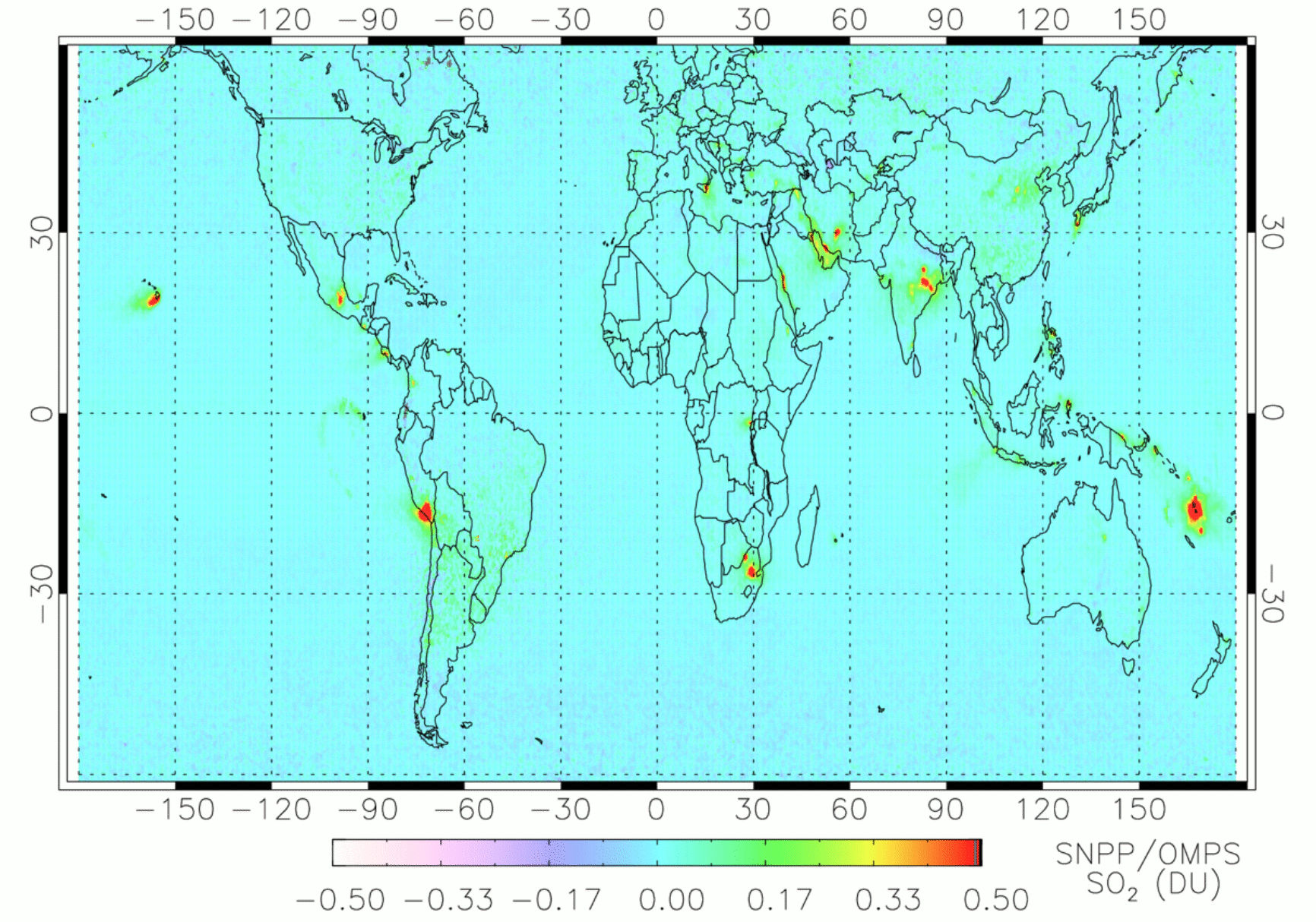
OMPS/NPP PCA SO2 Total Column 1-Orbit L2 Swath 50x50km V2 (OMPS_NPP_NMSO2_PCA_L2) at GES DISC
National Aeronautics and Space Administration —
The OMPS_NPP_NMSO2_PCA_L2 product is part of the MEaSUREs (Making Earth Science Data Records for Use in Research Environments) suite of products.It is retrieved from... -
Federal
AirMSPI verison 6 ellipsoid-projected georegistered radiance product acquired during the SPEX-PR flight campaign
National Aeronautics and Space Administration —
AirMSPI_SPEX-PR_Ellipsoid-projected_Georegistered_Radiance_Data is an AirMSPI ellipsoid-projected georegistered radiance product acquired during the SPEX engineering... -
Federal
AirMSPI verison 6 terrain-projected georegistered radiance product acquired during the SPEX-PR flight campaign
National Aeronautics and Space Administration —
AirMSPI_SPEX-PR_Terrain-projected_Georegistered_Radiance_Data is an AirMSPI terrain-projected georegistered radiance product acquired during the SPEX engineering... -
Federal
Small Magellanic Cloud Wing Survey Chandra X-Ray Point Source Catalog
National Aeronautics and Space Administration —
The authors have detected 523 X-ray sources in a survey of the Small Magellanic Cloud (SMC) Wing with the Chandra X-ray Observatory. By cross-correlating the X-ray... -
Federal
NGC 1332 Chandra X-Ray Compact Source Catalog
National Aeronautics and Space Administration —
Chandra ACIS-S3 (Advanced CCD Imaging Spectrometer) observations of the nearby S0 galaxy NGC 1332 resolve much of the X-ray emission into 73 point sources, of which... -
Federal
SCOAPE Pandora Column Observations
National Aeronautics and Space Administration —
SCOAPE_Pandora_Data is the column NO2 and ozone data collected by Pandora spectrometers during the Satellite Coastal and Oceanic Atmospheric Pollution Experiment... -
Federal
SCOAPE Ground Site Data
National Aeronautics and Space Administration —
SCOAPE_Ground_Data is the ground site data collected during the Satellite Coastal and Oceanic Atmospheric Pollution Experiment (SCOAPE). The ground site was located... -
Federal
Blue Carbon-based Natural Climate Solutions, Priority Maps for the U.S., 2006-2011
National Aeronautics and Space Administration —
This dataset contains shapefiles showing location of tidal wetland parcels with the potential for net greenhouse gas removal if restored from current mapped condition...
75 datasets found for "Natural Gas"