
-
Federal
Last of the Wild Project, Version 1, 2002 (LWP-1): Global Human Footprint Dataset (IGHP)
National Aeronautics and Space Administration —
The Global Human Footprint Dataset of the Last of the Wild Project, Version 1, 2002 (LWP-1) is the Human Influence Index (HII) normalized by biome and realm. The HII... -
Federal
Vulcan: High-Resolution Annual Fossil Fuel CO2 Emissions in USA, 2010-2015, Version 3
National Aeronautics and Space Administration —
The Vulcan version 3.0 annual dataset provides estimates of annual carbon dioxide (CO2) emissions from the combustion of fossil fuels (FF) and CO2 emissions from... -
Federal
Yup'ik Environmental Knowledge Project, Version 1
National Aeronautics and Space Administration —
Over the last ten years the Calista Elders Council (CEC) staff has worked with elders from Bering Sea coastal communities to document Yup'ik place names. Elders have... -
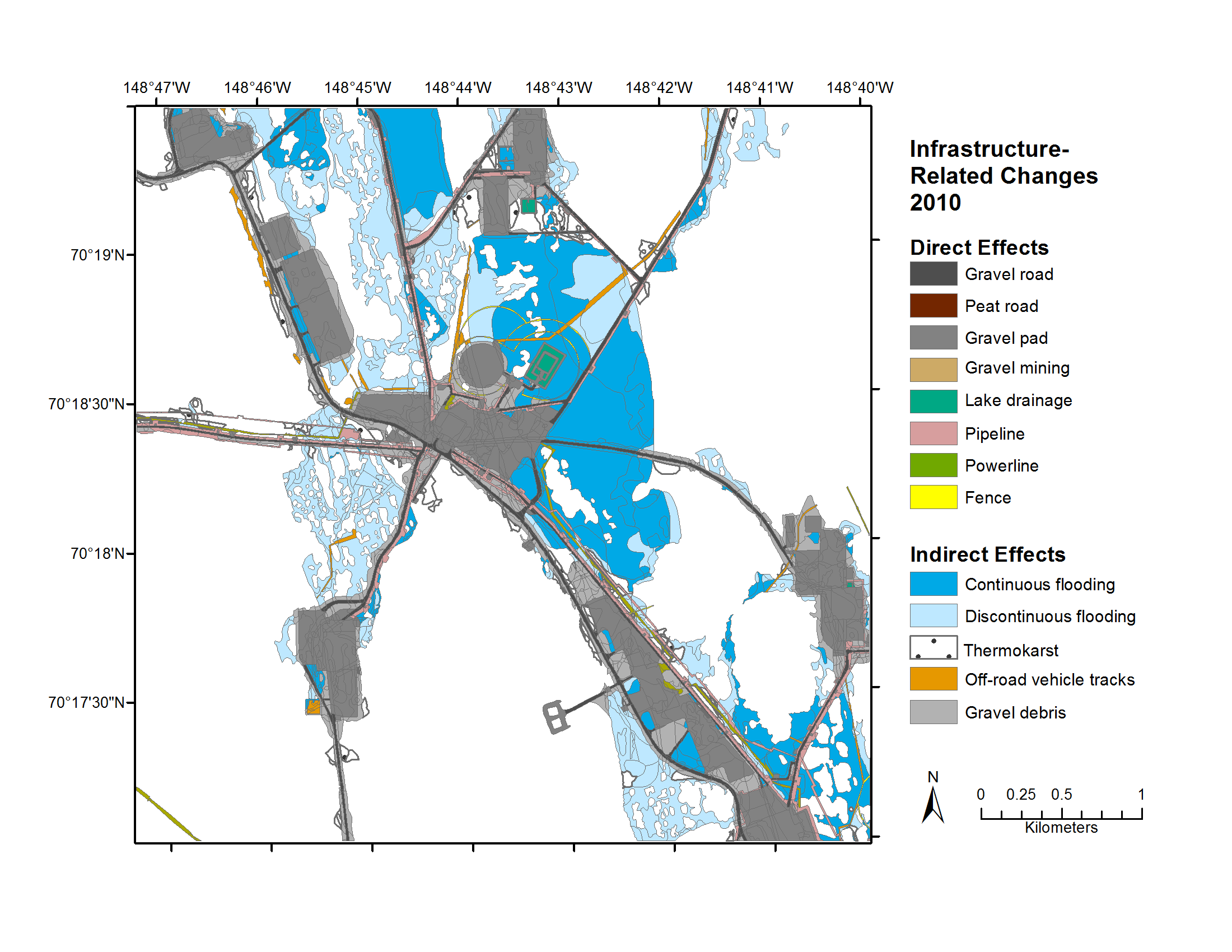
Federal
Geobotanical and Impact Map Collection for Prudhoe Bay Oilfield, Alaska, 1972-2010
National Aeronautics and Space Administration —
This data set provides a collection of maps of geoecological characteristics of areas within the Beechey Point quadrangle near Prudhoe Bay on the North slope of... -
Federal
USGS Group on Earth Observations (GEO) Global Agricultural Monitoring (GLAM) Russia
National Aeronautics and Space Administration —
The objective of GEO is to fulfil a vision of a world where decisions and actions are informed by coordinated, comprehensive and sustained Earth Observation (EO).... -
Federal
Aerial Photographs (from AMES Pilot Land Data System); USGS EDC, Sioux Falls
National Aeronautics and Space Administration —
The aerial photography inventoried by the Pilot Land Data System (PLDS) at NASA AMES Research Center has been transferred to the USGS EROS Data Center. The photos... -
Federal
Data from Sustainability Base Characterizing Hot Water Pump Differential Pressure Spikes for ACCEPT
National Aeronautics and Space Administration —
During the heating season in Sustainability Base, a critical alarm associated with a hot water pump circulating heating water for the radiative system which exchanges... -
Federal
SAL and PVS Model of TTEthernet Synchronization Protocol
National Aeronautics and Space Administration —
Timed-Triggered Ethernet (or TTEthernet)is a communication infrastructure that enables the use of Ethernet in real-time, distributed systems. TTEthernet is compatible... -
Federal
GEDI L2B Canopy Cover and Vertical Profile Metrics Data Global Footprint Level V002
National Aeronautics and Space Administration —
The Global Ecosystem Dynamics Investigation (GEDI) mission aims to characterize ecosystem structure and dynamics to enable radically improved quantification and... -
Federal
Global Ocean Biogeochemistry Array
National Aeronautics and Space Administration —
The Global Ocean Biogeochemistry (GO-BGC) Array is a project funded by the US National Science Foundation (NSF Award 1946578 ) to build a global network of chemical... -
Federal
GEDI L1B Geolocated Waveform Data Global Footprint Level V002
National Aeronautics and Space Administration —
The Global Ecosystem Dynamics Investigation (GEDI) mission aims to characterize ecosystem structure and dynamics to enable radically improved quantification and... -
Federal
Tracking Logistical Constraints Across Missions and Organizations: A Multipurpose Information Infrastructure
National Aeronautics and Space Administration —
execute plans and schedules that achieve stated goals while simultaneously minimizing the cost of logistics management and maximizing resource productivity. This goal... -
Federal
USGS Group on Earth Observations (GEO) Global Agricultural Monitoring (GLAM) Australia
National Aeronautics and Space Administration —
The objective of GEO is to fulfil a vision of a world where decisions and actions are informed by coordinated, comprehensive and sustained Earth Observation (EO).... -
Federal
Software Infrastructure to Enable Modeling & Simulation as a Service (M&SaaS) Project
National Aeronautics and Space Administration —
Software Infrastructure to Enable Modeling & Simulation as a Service (M&SaaS) Project -
Federal
MOOSE Aerodyne Mobile Laboratory Measurements
National Aeronautics and Space Administration —
MOOSE_Aerodyne-Mobile-Laboratory_1 is the data collected by the Aerodyne Mobile Laboratory (AML) during the Michigan-Ontario Ozone Source Experiment (MOOSE).... -
Federal
SnowEx17 CRREL Differential GNSS Survey V001
National Aeronautics and Space Administration —
This data set contains the coordinates of SnowEx infrastructure in Grand Mesa, Colorado, collected through a differential GNSS real-time kinematic (RTK) survey. The... -
Federal
LBA-ECO LC-01 City, Community, and Road Maps, Northern Ecuadorian Amazon: 1990-2002
National Aeronautics and Space Administration —
This data set contains the boundaries of the four major cities in the Northern Ecuadorian Amazon, the locations of primary communities in the colonist settlement... -
Federal
Randolph Glacier Inventory - A Dataset of Global Glacier Outlines, Version 5
National Aeronautics and Space Administration —
The Randolph Glacier Inventory (RGI) is a global set of glacier outlines; it is intended as a snapshot of the world’s glaciers. This data set provides a single...

Official websites use .gov
A
.gov website belongs to an official government
organization in the United States.
Secure .gov websites use HTTPS
A
lock (
) or https:// means you’ve safely connected to
the .gov website. Share sensitive information only on official,
secure websites.