

7,032 datasets found for "45j채널방디비판매업체❤️텔레darknessDB|◎"
-
Federal
MODIS/Terra+Aqua BRDF/Albedo Quality Daily L3 Global 500 m SIN Grid
National Aeronautics and Space Administration —
The MODIS Near Real Time (NRT) Combined Aqua and Terra Bidirectional Reflectance Distribution Function and Albedo (BRDF/Albedo) Quality, MCD43A2N is a L3 daily 16-day... -
Federal
VIIRS/JPSS1 BRDF/Albedo Parameter 3 DNB Daily L3 Global 30 ArcSec CMG V002
National Aeronautics and Space Administration —
The NOAA-20 Visible Infrared Imaging Radiometer Suite (VIIRS) Bidirectional Reflectance Distribution Function (BRDF) and Albedo Model Parameter 3 Day-Night Band (DNB)... -
Federal
VIIRS/NPP BRDF/Albedo Parameter 1 NIR Daily L3 Global 30 ArcSec CMG V002
National Aeronautics and Space Administration —
The NASA/NOAA Suomi National Polar-orbiting Partnership (Suomi NPP) Visible Infrared Imaging Radiometer Suite (VIIRS) Bidirectional Reflectance Distribution Function... -
Federal
TES/Aura L2 Water Vapor Nadir V008
National Aeronautics and Space Administration —
TL2H2ON_8 is the Tropospheric Emission Spectrometer (TES)/Aura Level 2 Water Vapor Nadir Version 8 data product. TES was an instrument aboard NASA's Aura satellite... -
Federal
Standard Deviation of Monthly Frequency of Dust Storm over Land for Varying Intensities, Based on MODIS Aqua Deep Blue Level 2 Aerosol Products MYD04_L2 Collection 6.1, on a Global 0.1 by 0.1 Degree Grid, Level 3 Version 1 (MYDFDS_SDV_GLB_L3) at GES DISC
National Aeronautics and Space Administration —
Version 1 is the current version of the dataset.This collection MYDFDS_SDV_GLB_L3 provides level 3 standard deviation of climatological monthly frequency of dust... -
Federal
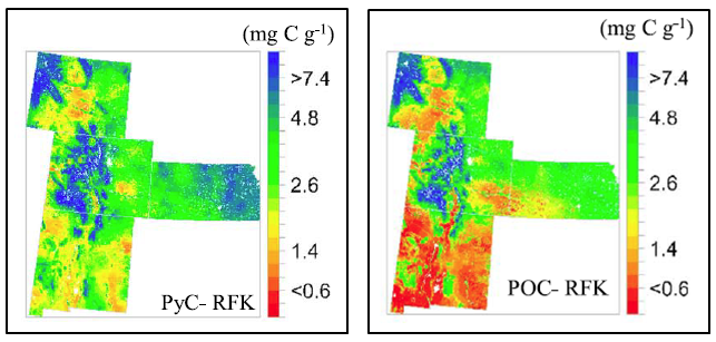
Stocks of Surface Soil Organic Carbon Fractions, Great Plains Region, USA, 2007-2010
National Aeronautics and Space Administration —
This dataset provides estimates of total organic soil carbon (SOC), pyrogenic (PyC), particulate (POC), and other organic soil carbon (OOC) fractions in 473 surface... -
Federal
Sounder SIPS: Suomi NPP CrIMSS Level 2 CLIMCAPS Full Spectral Resolution: Atmospheric state at Standard Pressure Levels derived from CLIMCAPS V2.1 (SNDRSNIML2PLEVCPS) at GES DISC
National Aeronautics and Space Administration —
The CLIMCAPS (Community Long-term Infrared Microwave Coupled Product System) algorithm is used to analyze data from the Cross-track Infrared Sounder/Advanced... -
Federal
SMEX02 Soil Moisture Atmosphere Coupling Experiment (SMACEX), Iowa, Version 1
National Aeronautics and Space Administration —
This data set contains measurements collected from flights conducted in June and July 2002 over the Walnut Creek watershed in central Iowa, USA. -
Federal
Satellite Laser Ranging (SLR) ILRS Combination Center (CC) Station Position and Earth Rotation Parameters (ERP) Product (weekly files, generated daily) from NASA CDDIS
National Aeronautics and Space Administration —
This derived product set consists of Satellite Laser Ranging Final Station Position plus ERP Product (daily files, generated daily) from the NASA Crustal Dynamics... -
Federal
Satellite SPOT Extracted Data (FIFE)
National Aeronautics and Space Administration —
The Site Reflectances Extracted from SPOT HRV Imagery Data Set contains the average instrument corrected spectral radiances for each of the spectral bands (3 in XS... -
Federal
SEASAT SCATTEROMETER DEALIASED OCEAN WIND VECTORS (Wentz et al.)
National Aeronautics and Space Administration —
Contains Seasat-A Scatterometer (SASS) wind vector measurements for the entire Seasat mission, from July 1978 until October 1978. The data are global and presented... -
Federal
MODIS/Terra+Aqua BRDF/Albedo Nadir BRDF-Adjusted Ref Daily L3 Global 0.05Deg CMG V006
National Aeronautics and Space Administration —
The MCD43C4 Version 6 data product was decommissioned on July 31, 2023. Users are encouraged to use the MCD43C4 Version 6.1 data product.The Moderate Resolution...
7,032 datasets found for "45j채널방디비판매업체❤️텔레darknessDB|◎"