
-
Federal
Global Food Security-support Analysis Data (GFSAD) Cropland Extent 2015 South America product 30 m V001
National Aeronautics and Space Administration —
The NASA Making Earth System Data Records for Use in Research Environments (MEaSUREs) Global Food Security-support Analysis Data (GFSAD) data product provides... -
Federal
Global Food Security-support Analysis Data (GFSAD) Cropland Extent 2015 Africa 30 m V001
National Aeronautics and Space Administration —
The NASA Making Earth System Data Records for Use in Research Environments (MEaSUREs) Global Food Security-support Analysis Data (GFSAD) data product provides... -
Federal
Global Soil Texture and Derived Water-Holding Capacities (Webb et al.)
National Aeronautics and Space Administration —
A standardized global data set of soil horizon thicknesses and textures (particle size distributions) was compiled by Webb et al. This data set will be used for the... -
Federal
Global Hyperspectral Imaging Spectral-library of Agricultural crops for Central Asia V001
National Aeronautics and Space Administration —
The Global Hyperspectral Imaging Spectral-library of Agricultural crops (GHISA) is a comprehensive compilation, collation, harmonization, and standardization of... -
Federal
Tidal Wetland Soil Carbon Stocks for the Conterminous United States, 2006-2010
National Aeronautics and Space Administration —
This dataset provides modeled estimates of soil carbon stocks for tidal wetland areas of the Conterminous United States (CONUS) for the period 2006-2010. Wetland... -
Federal
TransCom 3: Seasonal CO2 Flux Estimates from Atmospheric Inversions (Level 2)
National Aeronautics and Space Administration —
This data set provides model outputs and seasonal mean CO2 fluxes from the Atmospheric Carbon Cycle Inversion Intercomparison (TransCom 3), Level 2 inversion... -
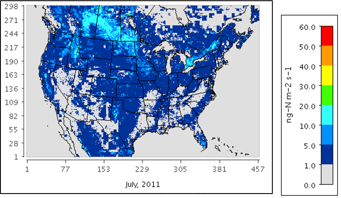
Federal
Mechanistic Module for Soil Nitrogen Emissions for CMAQ Model, North America, 2011
National Aeronautics and Space Administration —
This model product provides source code, input data files, and example model outputs for a new mechanistic soil nitrogen (N) module in-line with the Community... -
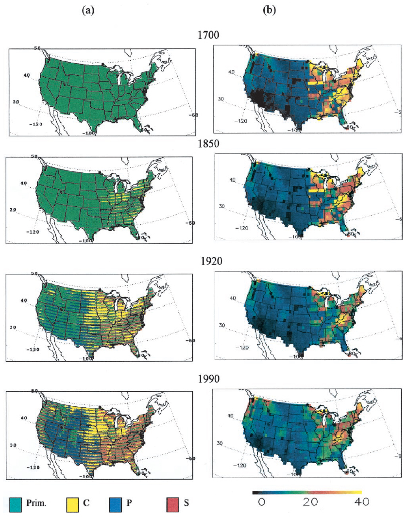
Federal
Ecosystem Demography Model: U.S. Ecosystem Carbon Stocks and Fluxes, 1700-1990
National Aeronautics and Space Administration —
This model product contains the source code for the Ecosystem Demography Model (ED version 1.0) as well as model input and output data files for the conterminous... -
Federal
Ecosystem Demography Model: Scaling Vegetation Dynamics Across South America
National Aeronautics and Space Administration —
This model product contains the source code for the Ecosystem Demography Model (ED version 1.0) as well as model input and output data for a portion of South America... -
Federal
Delta-X: NUMAR Predictive Model for Marsh Accretion Rates and Chemical Properties
National Aeronautics and Space Administration —
This dataset provides input data and model code to run the Marsh Accretion Rates (NUMAR) process model used to predict soil accretion rates and chemical properties... -
Federal
Delta-X: Matlab Model for Wax Lake Delta Land Accretion
National Aeronautics and Space Administration —
This dataset provides the Matlab sediment transport and land accretion model at Wax Lake Delta (WLD), Atchafalaya Basin, in coastal Louisiana. The data include the... -
Federal
Delta-X: In Situ Water Surface Reflectance across MRD, LA, USA, 2021, V3
National Aeronautics and Space Administration —
This dataset includes above water measurements of remote-sensing reflectance measured in situ at field sampling stations during the Delta-X 2021 field efforts.... -
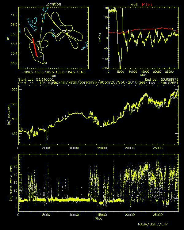
Federal
BOREAS Scanning Lidar Imager of Canopies by Echo Recovery (SLICER): Level-3 Data
National Aeronautics and Space Administration —
Scanning Lidar Imager of Canopies by Echo Recovery (SLICER) data were acquired in support of BOReal Ecosystem-Atmosphere Study (BOREAS) at all of the Tower Flux (TF)... -
Federal
BDSNP Module for Improved Soil NO Emission Estimates for CMAQ Model, Conterminous USA
National Aeronautics and Space Administration —
This model product provides: (1) the source code for the updated Berkeley-Dalhousie Soil Nitric Oxide (NO) Parameterization module (BDSNP, Version 1.0) as implemented... -
Federal
BOREAS TE-18 Geosail Canopy Reflectance Model
National Aeronautics and Space Administration —
The SAIL (Scattering from Arbitrarily Inclined Leaves) model was combined with the Jasinski geometric model to simulate canopy spectral reflectance and absorption of... -
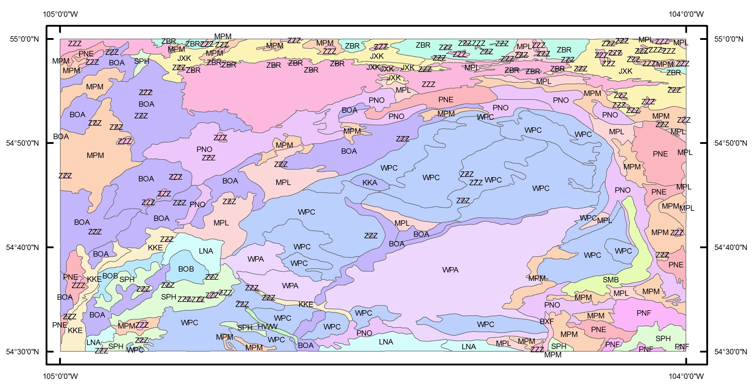
Federal
BOREAS Agriculture Canada Central Saskatchewan Vector Soils Data, R1
National Aeronautics and Space Administration —
This data set provides soil descriptions for forested areas in the BOREAS southern study area (SSA) in central Saskatchewan, Canada provided by Agriculture Canada.... -
Federal
Arctic Vegetation Plots Legacy Project Barter Island and Point Barrow, Alaska, 1994
National Aeronautics and Space Administration —
This dataset provides vegetation cover and environmental plot and soil data collected at two U.S. Air Force sites at Barter Island (BI) and Point Barrow (B), on the... -
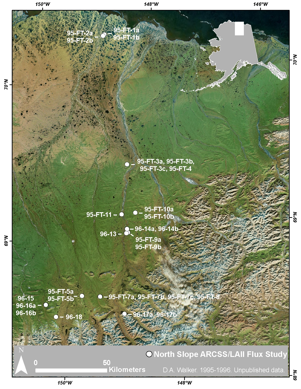
Federal
Arctic Vegetation Plots at ARCSS/LAII Flux Sites, North Slope, Alaska, 1995-1996
National Aeronautics and Space Administration —
This dataset provides vegetation cover and environmental plot and soil data collected at flux tower sites of the North Slope Arctic System Science/Land-Atmosphere-Ice... -
Federal
ABoVE: Synthesis of Burned and Unburned Forest Site Data, AK and Canada, 1983-2016
National Aeronautics and Space Administration —
This dataset is a synthesis of field plot characterization data, derived above-ground and below-ground combusted carbon, and acquired Fire Weather Index (FWI) System... -
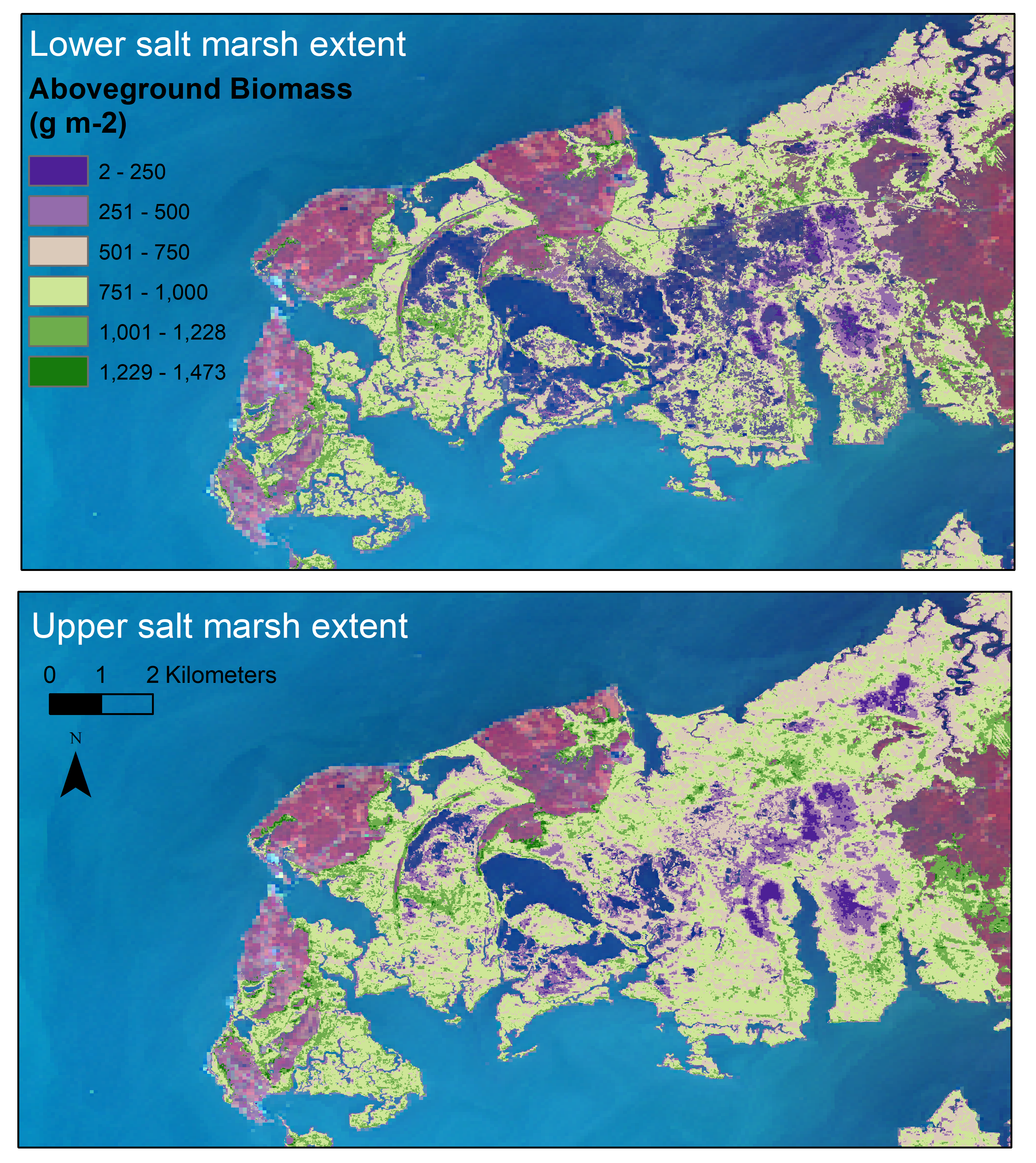
Federal
Aboveground Biomass Estimates for Salt Marsh for the Contiguous United States, 2020
National Aeronautics and Space Administration —
This dataset provides estimates of aboveground biomass (AGB) and salt marsh extent in the contiguous United States for 2020 and includes all coastal watersheds across...

Official websites use .gov
A
.gov website belongs to an official government
organization in the United States.
Secure .gov websites use HTTPS
A
lock (
) or https:// means you’ve safely connected to
the .gov website. Share sensitive information only on official,
secure websites.