
-
Federal
GVHRR/ATS-6 Black and White Visible Images on Film V001 (GVHRRATS6IMVIS) at GES DISC
National Aeronautics and Space Administration —
GVHRRATS6IMVIS is the Geosynchronous Very High Resolution Radiometer (GVHRR) Black and White Visible Images on Film data product from the sixth Applications... -
Federal
Landsat-based Phenology and Tree Ring Characterization, Eastern US Forests, 1984-2013
National Aeronautics and Space Administration —
This data set provides a 30-year record of Landsat TM and ETM+ derived forest phenology and the results of tree ring analyses for annual wood production and nitrogen... -
Federal
BOREAS TGB-07 Ambient Air Herbicide and Organochlorine Concentration Data
National Aeronautics and Space Administration —
The BOREAS TGB-07 team measured the concentration and flux of several agricultural pesticides in air, rainwater, and dry deposition samples in order to determine the... -
Federal
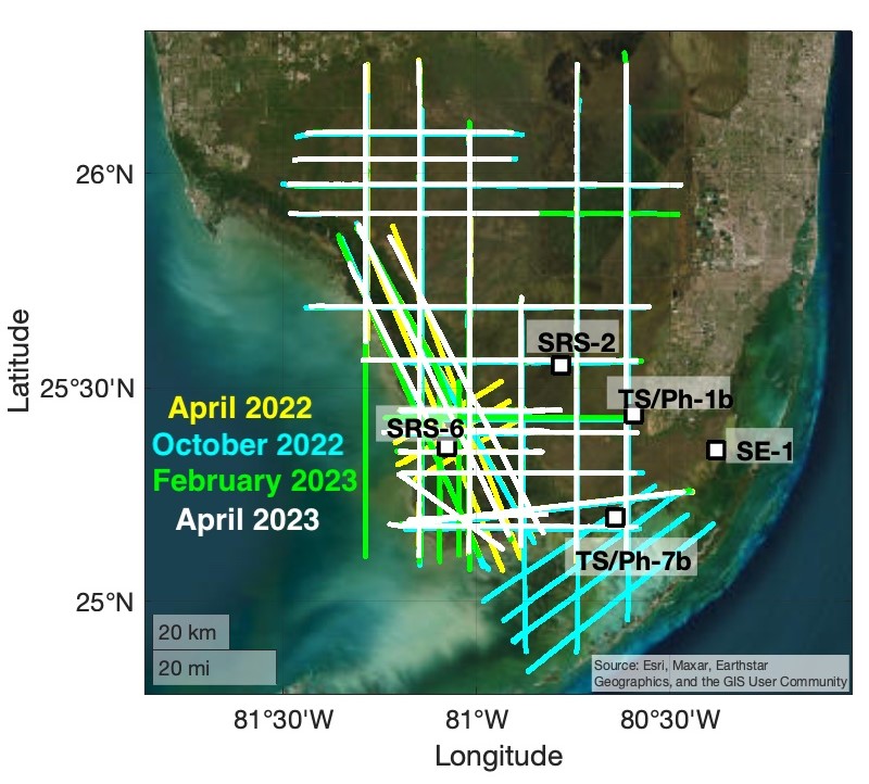
BlueFlux Airborne Trace Gases, Fluxes, and Mixing Ratios, Southern Florida, 2022-2023
National Aeronautics and Space Administration —
This dataset includes airborne in situ measurements of greenhouse gas mixing ratios, meteorological parameters, and fluxes (CO2, CH4, latent heat fluxes, friction... -
Federal
NARSTO EPA Supersite (SS) Pittsburgh Gas Concentration and Particulate matter (PM) Physical Properties Data
National Aeronautics and Space Administration —
NARSTO_EPA_SS_PITTSBURGH_GAS_PM_PROPERTY_DATA is the North American Research Strategy for Tropospheric Ozone (NARSTO) Environmental Protection Agency (EPA) Supersite... -
Federal
NARSTO EPA Supersite (SS) Pittsburgh Particulate Matter (PM) Composition Data
National Aeronautics and Space Administration —
NARSTO_EPA_SS_PITTSBURGH_PM_COMPOSITION_DATA is the North American Research Strategy for Tropospheric Ozone (NARSTO) Environmental Protection Agency (EPA) Supersite... -
Federal
NARSTO PAC2001 CFS Cessna VOC, Particle Count, Ozone, and Meteorological Data
National Aeronautics and Space Administration —
The NARSTO_PAC2001_CESSNA_VOC_PM_OZONE_MET_DATA were obtained between August 14 and August 31, 2001 during the Pacific 2001 Air Quality Study (PAC2001).The missions... -
Federal
S-PASS (S-Band Polarization All-Sky Survey) 2.3-GHz Source Catalog
National Aeronautics and Space Administration —
The S-band Polarization All-Sky Survey (S-PASS) has observed the entire southern sky using the 64-meter Parkes radio telescope at 2.3 GHz with an effective bandwidth... -
Federal
ABoVE: Dall Sheep Response to Snow and Landscape Covariates, Alaska, 2005-2008
National Aeronautics and Space Administration —
This dataset provides daily estimates of snow depth and snow density for the study area in Lake Clark National Park and Preserve (LCNPP), Alaska. The data were... -
Federal
SMALL MAIN-BELT ASTEROID SPECTROSCOPIC SURVEY, PHASE II
National Aeronautics and Space Administration —
This data set contains visible-wavelength (0.435-0.925 micron) spectra for 1341 main-belt asteroids observed during the second phase of the Small Main-belt Asteroid... -
Federal
HUYGENS PROBE DWE RESULTS V1.0
National Aeronautics and Space Administration —
The DWE data set consists of the sky frequencies measured at the Green Bank and Parkes telescopes (data from other stations may be included when they become... -
Federal
AfriSAR: Aboveground Biomass for Lope, Mabounie, Mondah, and Rabi Sites, Gabon
National Aeronautics and Space Administration —
This dataset provides gridded estimates of aboveground biomass (AGB) for four sites in Gabon at 0.25 ha (50 m) resolution derived with field measurements and airborne... -
Federal
VISSR/SMS-2 Level 1 Atmospheric and Oceanographic Image Processing System (AOIPS) Data V001 (VISSRSMS2L1AOIPS) at GES DISC
National Aeronautics and Space Administration —
VISSRSMS2L1AOIPS is the Visible Infrared Spin-Scan Radiometer (VISSR) Level 1 Atmospheric and Oceanographic Image Processing System (AOIPS) data product from the... -
Federal
SCOAPE Balloon and Ozonesondes Data
National Aeronautics and Space Administration —
SCOAPE_Sondes_Data is the NO2-sonde and ozonesonde data collected during the Satellite Coastal and Oceanic Atmospheric Pollution Experiment (SCOAPE). Data were... -
Federal
UAVSAR_POLSAR_ML_COMPLEX_GRD_3X3
National Aeronautics and Space Administration —
UAVSAR PolSAR Scene Projected Multilook 3x3 -
Federal
UAVSAR_INSAR_INTERFEROGRAM
National Aeronautics and Space Administration —
UAVSAR Repeat Pass Interferometry Scene -
Federal
MOOSE Aerodyne Mobile Laboratory Measurements
National Aeronautics and Space Administration —
MOOSE_Aerodyne-Mobile-Laboratory_1 is the data collected by the Aerodyne Mobile Laboratory (AML) during the Michigan-Ontario Ozone Source Experiment (MOOSE).... -
Federal
VISSR/SMS-2 Level 1 Experimenter History Data V001 (VISSRSMS2L1EHT) at GES DISC
National Aeronautics and Space Administration —
VISSRSMS2L1EHT is the Visible Infrared Spin-Scan Radiometer (VISSR) Level 1 Experimenter History Tape (EHT) data product from the second Synchronous Meteorological... -
Federal
UAVSAR_INSAR_INTERFEROGRAM_GRD
National Aeronautics and Space Administration —
UAVSAR Repeat Pass Interferometry Ground Projected Scene -
Federal
SCOAPE-II Sondes Data
National Aeronautics and Space Administration —
SCOAPE2_Sondes_Data is the ozonesonde data collected during the Satellite Coastal and Oceanic Atmospheric Pollution Experiment - II (SCOAPE-II). Data collection for...

Official websites use .gov
A
.gov website belongs to an official government
organization in the United States.
Secure .gov websites use HTTPS
A
lock (
) or https:// means you’ve safely connected to
the .gov website. Share sensitive information only on official,
secure websites.