
-
Federal
IBEX High Energy Neutral Atom Imager (Hi) Data Release 16, not Compton-Getting corrected, Survival Probability corrected, Ram direction, West Longitude Ecliptic Maps, Level H3 (H3), annually averaged Data
National Aeronautics and Space Administration —
1: The Interstellar Boundary Explorer (IBEX) has operated in space since 2008 updating our knowledge of the outer heliosphere and its interaction with the local... -
Federal
IBEX High Energy Neutral Atom Imager (Hi) Data Release 16, Compton-Getting corrected, not Survival Probability corrected, Omnidirectional, West Longitude Ecliptic Maps, Level H3 (H3), semiannually averaged Data
National Aeronautics and Space Administration —
1: The Interstellar Boundary Explorer (IBEX) has operated in space since 2008 updating our knowledge of the outer heliosphere and its interaction with the local... -
Federal
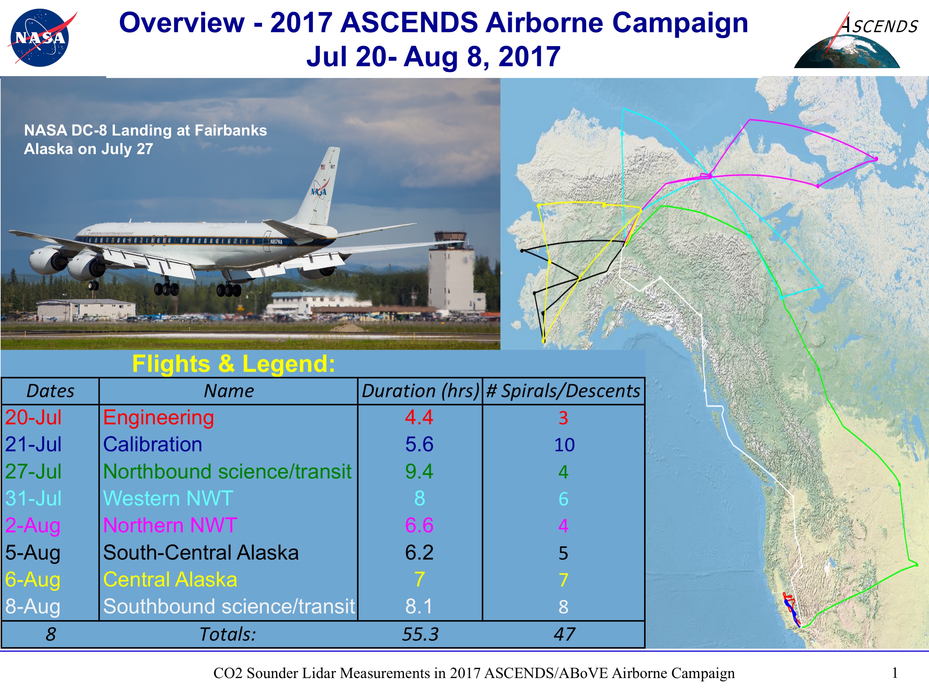
ABoVE/ASCENDS: Merged Atmospheric CO2, CH4, and Meteorological Data, 2017
National Aeronautics and Space Administration —
This dataset provides in situ airborne measurements of atmospheric carbon dioxide (CO2), methane (CH4), water vapor concentrations, air temperature, pressure, and... -
Federal
ISEE 1 Solar Wind Weimer Propagation Details at 1 min Resolution
National Aeronautics and Space Administration —
ISEE-1 Weimer propagated solar wind data and linearly interpolated time delay, cosine angle, and goodness information of propagated data at 1 min Resolution. This... -
Federal
IBEX High Energy Neutral Atom Imager (Hi) Data Release 04, Compton-Getting corrected, Survival Probability corrected, Omnidirectional, West Longitude Ecliptic Maps, Level H3 (H3), semiannually averaged Data
National Aeronautics and Space Administration —
1: The Interstellar Boundary Explorer (IBEX) has operated in space since 2008 updating our knowledge of the outer heliosphere and its interaction with the local... -
Federal
IBEX High Energy Neutral Atom Imager (Hi) Data Release 16, Compton-Getting corrected, not Survival Probability corrected, Ram direction, West Longitude Ecliptic Maps, Level H3 (H3), eleven year average Data
National Aeronautics and Space Administration —
1: The Interstellar Boundary Explorer (IBEX) has operated in space since 2008 updating our knowledge of the outer heliosphere and its interaction with the local... -
Federal
MISR Level 2 TOA/Cloud Stereo Product subset for the GoMACCS region V002
National Aeronautics and Space Administration —
GOMI2ST_002 is the Multi-angle Imaging SpectroRadiometer (MISR) Level 2 TOA/Cloud Stereo Product subset for the GoMACCS region version 2. It contains the... -
Federal
Jason-1 GDR version E NetCDF
National Aeronautics and Space Administration —
The Jason-1 Geophysical Data Records (GDR) contain full accuracy altimeter data to measure sea surface height, with a high precision orbit (accuracy ~1.5 cm). The... -
Federal
IBEX High Energy Neutral Atom Imager (Hi) Data Release 16, not Compton-Getting corrected, Survival Probability corrected, Antiram direction, West Longitude Ecliptic Maps, Level H3 (H3), eleven year average Data
National Aeronautics and Space Administration —
1: The Interstellar Boundary Explorer (IBEX) has operated in space since 2008 updating our knowledge of the outer heliosphere and its interaction with the local... -
Federal
Wind Energetic Particle Acceleration Composition Transport (EPACT) SupraThermal Energetic Particle Telescope (STEP) Differential, Directional Carbon, Nitrogen, and Oxygen Fluxes, 10 min Data
National Aeronautics and Space Administration —
The EPACT Instrument on Wind STEP - SupraThermal Energetic Particle Telescope measures Ion Fluxes of Protons (H) in 0.12.5 MeV Energy Range and He-Fe Nuclei in the... -
Federal
PISTON 2018-2019 Island Rawinsonde Data
National Aeronautics and Space Administration —
PISTON-ONR-NOAA_Islands_2018-2019 is the Propagation of Intra-Seasonal Tropical Oscillations (PISTON) 2018-2019 island rawinsonde data product. This product is the... -
Federal
SARP 2018 Data
National Aeronautics and Space Administration —
SARP_2018_Data is the data collected onboard the NASA DC-8 aircraft during the 2018 deployment of the Student Airborne Research Program (SARP) mission. Data... -
Federal
First ISCCP Regional Experiment (FIRE) Cirrus Phase II NCAR Sabreliner Aircraft Microphysical Data
National Aeronautics and Space Administration —
The First ISCCP Regional Experiments have been designed to improve data products and cloud/radiation parameterizations used in general circulation models (GCMs).... -
Federal
SPURS-2 Rawinsonde meteorological data for the E. Tropical Pacific field campaign R/V Revelle cruises
National Aeronautics and Space Administration —
The SPURS (Salinity Processes in the Upper Ocean Regional Study) project is NASA-funded oceanographic process study and associated field program that aim to elucidate... -
Federal
ARISE C-130 Aircraft Merge Data Files
National Aeronautics and Space Administration —
ARISE_Merge_Data_1 is the Arctic Radiation - IceBridge Sea & Ice Experiment (ARISE) 2014 pre-generated aircraft (C-130) merge data files. This product is a result... -
Federal
First ISCCP Regional Experiment (FIRE) Atlantic Stratocumulus Transition Experiment (ASxTEX) ECMWF Basic Fields Data
National Aeronautics and Space Administration —
A special set of analysis products for the Atlantic Stratocumulus Transition Experiment (ASTEX) region during June 1-28, 1992 was prepared by Ernst Klinker and Tony... -
Federal
DC3 In-Situ NSF/NCAR GV-HIAPER Meteorological and Navigational Data
National Aeronautics and Space Administration —
DC3_MetNav_AircraftInSitu_NSF-GV-HIAPER_Data are in-situ meteorological and navigational data collected onboard the NSF/NCAR GV-HIAPER aircraft during the Deep... -
Federal
SEAC4RS ER-2 Aircraft In-Situ Meteorological and Navigational Data
National Aeronautics and Space Administration —
SEAC4RS_MetNav_AircraftInSitu_ER2_Data are in-situ meteorological and navigational data collected onboard the ER-2 aircraft during the Studies of Emissions and...

Official websites use .gov
A
.gov website belongs to an official government
organization in the United States.
Secure .gov websites use HTTPS
A
lock (
) or https:// means you’ve safely connected to
the .gov website. Share sensitive information only on official,
secure websites.