
-
Federal
Gakona THEMIS Ground-based All Sky Imager; Full Resolution Images.
National Aeronautics and Space Administration —
THEMIS Ground All Sky Imager at Gakona (62.39 deg GLat, 214.87 deg GLong): 256 x 256 pixel full resolution images of auroral oval. The ASI stations monitor a 170... -
Federal
Antares Cartagena station, Colombia
National Aeronautics and Space Administration —
Antares Cartagena station is located 10 km offshore, across from the Cartagena Bay/Caribbean Sea at 75° 36'W, 10° 22'N in Cartagena, Colombia. Activities in the... -
Federal
THEMIS GBO All Sky Imager at Gakona, AK. ASI Thumbnails Data.
National Aeronautics and Space Administration —
THEMIS Ground All Sky Imager at Gakona (62.39 deg GLat, 214.87 deg GLong): 32 x 32 pixel thumbnails for full ASI images. The ASI stations monitor a 170 degree field... -
Federal
Goose Bay THEMIS Ground-based All Sky Imager; Full Resolution Images.
National Aeronautics and Space Administration —
THEMIS Ground All Sky Imager at Goose Bay (53.32 deg GLat, 299.54 deg GLong): 256 x 256 pixel full resolution images of auroral oval. The ASI stations monitor a 170... -
Federal
MSL MARS ROVER ENVIRONMENTAL MONITORING STATION 2 EDR V1.0
National Aeronautics and Space Administration —
Raw, unprocessed scientific and housekeeping engineering data taken from the Rover Environmental Monitoring Station (REMS) aboard the Mars Science Laboratory. -
Federal
First Galactic Plane Survey at 8.35 and 14.35 GHz
National Aeronautics and Space Administration —
This table contains results from the first Galactic Plane (GP) Survey at 8.35 and 14.35 GHz (3.6 and 2.1 cm). In this project, the first images of the GP in the... -
Federal
NARSTO 1998 Model-Intercomparison Study Verification Data: NARSTO-Northeast 1995 Surface Ozone, NO, and NOx Langley Data Center Data Set
National Aeronautics and Space Administration —
NARSTO_NE_MODEL is the North American Research Strategy for Tropospheric Ozone (NARSTO) 1998 Model-Intercomparison Study Verification Data: NARSTO-Northeast 1995... -
Federal
NARSTO EPA Supersite (SS) Houston, Texas Air Quality Study 2000 (TexAQS2000) Texas Natural Resource Conservation Commission (TNRCC) continuous ambient monitoring stations (CAMS) Air Quality Data
National Aeronautics and Space Administration —
NARSTO_EPA_HOUSTON_TEXAQS2000_CAMS_DATA is the North American Research Strategy for Tropospheric Ozone (NARSTO) Environmental Protection Agency (EPA) Supersite (SS)... -
Federal
Seasonal frost and soil temperature data, Western Cape Mountains, South Africa, Version 1
National Aeronautics and Space Administration —
Micro-climatic monitoring of air and ground was started in 1990 to evaluate climatic controls on the present-day diurnal soil frost environment in the Western Cape... -
Federal
NARSTO SOS99 Nashville WP-3D Orion Air Chemistry Data
National Aeronautics and Space Administration —
NARSTO_SOS99NASH_WP3D_CHEMISTRY_DATA is the North American Research Strategy for Tropospheric Ozone (NARSTO) SOS99 Nashville WP-3D Orion Air Chemistry Data product.... -
Federal
SAFARI 2000 Global Historical Climatology Network, V. 1, 1874-1990
National Aeronautics and Space Administration —
This data set consists of a southern African subset of the Global Historical Climatology Network (GHCN) Version 1 database. All stations with the following bounding... -
Federal
SAGE III/ISS L2 Solar Event Species Profiles (HDF5) V006
National Aeronautics and Space Administration —
g3bssp_6 is the Stratospheric Aerosol and Gas Experiment III (SAGE III) on the International Space Station (ISS) (SAGE III/ISS) Level 2 Solar Event Species Profiles... -
Federal
SAGE III/ISS L2 Monthly Lunar Event Species Profiles (NetCDF) V006
National Aeronautics and Space Administration —
g3blmnc_6 is the Stratospheric Aerosol and Gas Experiment III (SAGE III) on the International Space Station (ISS) (SAGE III/ISS) Level 2 Monthly Lunar Event Species... -
Federal
SAGE III/ISS L2 Lunar Event Species Profiles (HDF5) V006
National Aeronautics and Space Administration —
g3blsp_6 is the Stratospheric Aerosol and Gas Experiment III (SAGE III) on the International Space Station (ISS) (SAGE III/ISS) Level 2 Lunar Event Species Profiles... -
Federal
SAGE III/ISS L1B Solar Event Transmission Data (HDF5) V006
National Aeronautics and Space Administration —
g3bt_6 is the Stratospheric Aerosol and Gas Experiment III (SAGE III) on the International Space Station (ISS) (SAGE III/ISS) Level 1B Solar Event Transmission Data... -
Federal
SAGE III/ISS L2 Lunar Event Species Profiles (Native) V006
National Aeronautics and Space Administration —
g3blspb_6 is the Stratospheric Aerosol and Gas Experiment III (SAGE III) on the International Space Station (ISS) (SAGE III/ISS) Level 2 Lunar Event Species Profiles... -
Federal
Ground-Based Satellite Laser Ranging (SLR) Observation Data (full-rate, daily, 24 hour files) from NASA CDDIS
National Aeronautics and Space Administration —
This dataset consists of ground-based Satellite Laser Ranging observation data (full-rate, daily 24 hour files) from the NASA Crustal Dynamics Data Information System... -
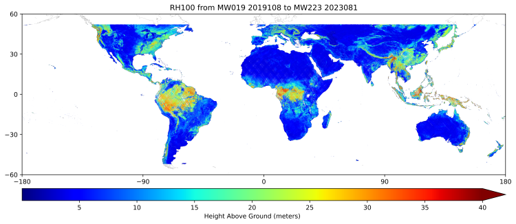
Federal
GEDI L3 Gridded Land Surface Metrics, Version 2
National Aeronautics and Space Administration —
This dataset provides Global Ecosystem Dynamics Investigation (GEDI) Level 3 (L3) gridded mean canopy height, standard deviation of canopy height, mean ground... -
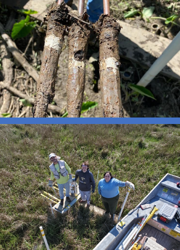
Federal
Delta-X: Feldspar Sediment Accretion Measurements, MRD, LA, USA, 2019-2023, Version 4
National Aeronautics and Space Administration —
This dataset provides elevation, hydrogeomorphic zone classification, soil carbon content, bulk density, organic matter content, and sediment accretion measurements... -
Federal
Yellowknife THEMIS Ground-based All Sky Imager; Full Resolution Images.
National Aeronautics and Space Administration —
THEMIS Ground All Sky Imager at Yellowknife (62.52 deg GLat, 245.69 deg GLong): 256 x 256 pixel full resolution images of auroral oval. The ASI stations monitor a 170...

Official websites use .gov
A
.gov website belongs to an official government
organization in the United States.
Secure .gov websites use HTTPS
A
lock (
) or https:// means you’ve safely connected to
the .gov website. Share sensitive information only on official,
secure websites.