
-
Federal
GEDI L2A Elevation and Height Metrics Data Global Footprint Level V002
National Aeronautics and Space Administration —
The Global Ecosystem Dynamics Investigation (GEDI) mission aims to characterize ecosystem structure and dynamics to enable... -
Federal
General Mission Analysis Tool Project
National Aeronautics and Space Administration —
Overview GMAT is a feature rich system containing high fidelity space system models, optimization and targeting,built in scripting and programming... -
Federal
RAMP AMM-1 SAR Image Mosaic of Antarctica, Version 2
National Aeronautics and Space Administration —
The mosaic provides a detailed look at ice sheet morphology, rock outcrops, research infrastructure, the coastline, and other features of Antarctica, as well as... -
Federal
Shared Socioeconomic Pathways (SSPs) Literature Database, v1, 2014-2019
National Aeronautics and Space Administration —
The Shared Socioeconomic Pathways (SSPs) Literature Database, v1, 2014-2019 consists of biographic information, abstracts, and analysis of 1,360 articles published... -
Federal
Plume Mitigation for Mars Terminal Landing: Soil Stabilization Project
National Aeronautics and Space Administration —
A sustained human presence on the Moon, Mars, or other celestial bodies, will require numerous disciplines to create technologies, solve current known... -
Federal
Sources of Methane Emissions (Vista-CA), State of California, USA
National Aeronautics and Space Administration —
This dataset provides spatial data products with identified and organized locations of potential methane (CH4) emitting facilities and infrastructure spanning the... -
Federal
Data from Sustainability Base Characterizing Hot Water Pump Differential Pressure Spikes for ACCEPT
National Aeronautics and Space Administration —
During the heating season in Sustainability Base, a critical alarm associated with a hot water pump circulating heating water for the radiative system which exchanges... -
Federal
SAL and PVS Model of TTEthernet Synchronization Protocol
National Aeronautics and Space Administration —
Timed-Triggered Ethernet (or TTEthernet)is a communication infrastructure that enables the use of Ethernet in real-time, distributed systems. TTEthernet is compatible... -
Federal
USGS Group on Earth Observations (GEO) Global Agricultural Monitoring (GLAM) Australia
National Aeronautics and Space Administration —
The objective of GEO is to fulfil a vision of a world where decisions and actions are informed by coordinated, comprehensive and sustained Earth Observation (EO).... -
Federal
Software Infrastructure to Enable Modeling & Simulation as a Service (M&SaaS) Project
National Aeronautics and Space Administration —
Software Infrastructure to Enable Modeling & Simulation as a Service (M&SaaS) Project -
Federal
IT Policies and Standards - NASA Information Technology and Institutional Infrastructure Program and Project Management Requirements
National Aeronautics and Space Administration —
The documents contained in this dataset reflect NASA's comprehensive IT policy in compliance with Federal Government laws and regulations. -
Federal
Planning to Explore: Using a Coordinated Multisource Infrastructure to Overcome Present and Future Space Flight Planning Challenges
National Aeronautics and Space Administration —
Few human endeavors present as much of a planning and scheduling challenge as space flight, particularly manned space flight. Just on the operational side of it,... -
Federal
Networked Instrumentation Element
National Aeronautics and Space Administration —
Armstrong researchers have developed a networked instrumentation system that connects modern experimental payloads to existing analog and digital communications... -
Federal
USGS Group on Earth Observations (GEO) Global Agricultural Monitoring (GLAM) Argentina
National Aeronautics and Space Administration —
The objective of GEO is to fulfil a vision of a world where decisions and actions are informed by coordinated, comprehensive and sustained Earth Observation (EO).... -
Federal
MOOSE Aerodyne Mobile Laboratory Measurements
National Aeronautics and Space Administration —
MOOSE_Aerodyne-Mobile-Laboratory_1 is the data collected by the Aerodyne Mobile Laboratory (AML) during the Michigan-Ontario Ozone Source Experiment (MOOSE).... -
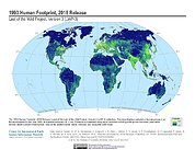
Federal
Last of the Wild Project, Version 3 (LWP-3): 1993 Human Footprint, 2018 Release
National Aeronautics and Space Administration —
The 1993 Human Footprint, 2018 Release provides a global map of the cumulative human pressure on the environment in 1993, at a spatial resolution of ~1 km. The human... -
Federal
SDG Indicator 11.7.1: Urban Public Space, Availability and Access, 2023 Release
National Aeronautics and Space Administration —
The SDG Indicator 11.7.1: Urban Public Space, Availability and Access, 2023 Release, part of the SDGI collection, measures the average share of the built-up area of a... -
Federal
USGS Group on Earth Observations (GEO) Global Agricultural Monitoring (GLAM) Algeria
National Aeronautics and Space Administration —
The objective of GEO is to fulfil a vision of a world where decisions and actions are informed by coordinated, comprehensive and sustained Earth Observation (EO).... -
Federal
West Africa Coastal Vulnerability Mapping: Subset of JRC Map of Accessibility
National Aeronautics and Space Administration —
The West Africa Coastal Vulnerability Mapping: Subset of JRC Map of Accessibility data set is a 30 arc-second raster of travel time to major cities in West Africa...

Official websites use .gov
A
.gov website belongs to an official government
organization in the United States.
Secure .gov websites use HTTPS
A
lock (
) or https:// means you’ve safely connected to
the .gov website. Share sensitive information only on official,
secure websites.