
-
Federal
ATom: Development of Cloud Indicator Algorithm Using Airborne Observations from CAPS
National Aeronautics and Space Administration —
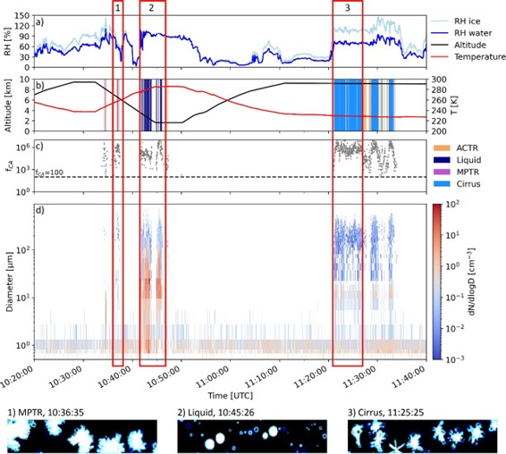
This dataset is the basis for the development of the Cloud Indicator, a novel algorithm that automatically detects and classifies measurement periods inside clouds.... -
Federal
STAQS Drone Data
National Aeronautics and Space Administration —
STAQS_Drone_Data is the PM 2.5 data collected by the BlueHalo E900 UAV during the Synergistic TEMPO Air Quality Science (STAQS) mission. Data collection for this... -
Federal
LBA-ECO CD-05 Soil VWC and Meteorology, Rainfall Exclusion, Tapajos National Forest
National Aeronautics and Space Administration —
This data set reports soil moisture expressed as volumetric water content (VWC), daily precipitation, air temperature, relative humidity, and dew point measurements... -
Federal
Sounder SIPS: Suomi NPP CrIMSS Level 2 SiFSAP Standard: Atmosphere cloud and surface geophysical state per footprint V2 (at GESDISC)
National Aeronautics and Space Administration —
This level 2 standard product is generated by the SiFSAP (Single Field-of-View Sounder Atmospheric Products) algorithm. The SIFSAP algorithm provides retrieval for... -
Federal
BOREAS AES Canadian Hourly and Daily Surface Meteorological Data, R1
National Aeronautics and Space Administration —
This data set contains hourly and daily meteorological data from 23 meteorological stations across Canada from January 1975 to January 1997. The surface meteorology... -
Federal
KORUS-AQ DC-8 Aircraft In Situ Meteorological and Navigational Data
National Aeronautics and Space Administration —
KORUSAQ_MetNav_AircraftInSitu_DC8_Data are in-situ meteorological and navigational data collected onboard the DC-8 aircraft during KORUS-AQ. This data product... -
Federal
BOREAS/AES Campbell Scientific 15-minute Surface Meteorological Data: 1994
National Aeronautics and Space Administration —
Canadian AES personnel collected data related to surface and atmospheric meteorological conditions over the BOREAS Region. This data set contains 15 minute... -
Federal
STAQS Balloonsondes and Ozonesondes Data
National Aeronautics and Space Administration —
STAQS_Sondes_Data is the balloonsonde and ozonesonde data collected during the Synergistic TEMPO Air Quality Science (STAQS) mission. Data collection for this product... -
Federal
Sounder SIPS: JPSS-1 ATMS Level 3 RAMSES2 Standard Gridded Daily V3 at GES DISC
National Aeronautics and Space Administration —
This level 3 daily product is generated from the RAMSES (Retrieval Algorithm for Microwave Sounders in Earth Science) II algorithm.The RAMSES II algorithm is a... -
Federal
GPM GROUND VALIDATION TOTAL PRECIPITATION SENSOR (HOTPLATE) GCPEX V1
National Aeronautics and Space Administration —
The GPM Ground Validation Total Precipitation Sensor (HotPlate) GCPEx dataset provides a measure of the liquid precipitation rate and accumulation for snow.... -
Federal
First ISCCP Regional Experiment (FIRE) Atlantic Stratocumulus Transition Experiment (ASTEX) Le Suroit Radiosonde Data
National Aeronautics and Space Administration —
The First ISCCP Regional Experiments have been designed to improve data products and cloud/radiation parameterizations used in general circulation models (GCMs).... -
Federal
Sounder SIPS: JPSS-1 ATMS Level 2 RAMSES2 Standard: Atmosphere, precipitation and surface geophysical state V3 (SNDRJ1ML2RMS) at GES DISC
National Aeronautics and Space Administration —
This level 2 product is generated by the RAMSES (Retrieval Algorithm for Microwave Sounders in Earth Science II algorithm.The RAMSES II algorithm is a microwave only... -
Federal
Sounder SIPS: AQUA AIRS IR + MW Level 2: Atmospheric state at Standard Pressure Levels derived from CLIMCAPS V2.1 (SNDRAQIML2PLEVCPS) at GES DISC
National Aeronautics and Space Administration —
The CLIMCAPS (Community Long-term Infrared Microwave Coupled Product System) algorithm is used to analyze data from the AIRS (Atmospheric Infrared Sounder)/AMSU... -
Federal
MERRA-2 inst3_3d_asm_Nv: 3d,3-Hourly,Instantaneous,Model-Level,Assimilation,Assimilated Meteorological Fields 0.625 x 0.5 degree V5.12.4 (M2I3NVASM) at GES DISC
National Aeronautics and Space Administration —
M2I3NVASM (or inst3_3d_asm_Nv) is an instantaneous 3-dimensional 3-hourly data collection in Modern-Era Retrospective analysis for Research and Applications version 2... -
Federal
SnowEx20 COSMOS Rover Soil Moisture V001
National Aeronautics and Space Administration —
This data set contains the raw and processed data files from a COSMOS Rover soil moisture probe. The COSMOS Rover uses fast neutron counting to estimate soil moisture... -
Federal
SARP 2018 Data
National Aeronautics and Space Administration —
SARP_2018_Data is the data collected onboard the NASA DC-8 aircraft during the 2018 deployment of the Student Airborne Research Program (SARP) mission. Data... -
Federal
Sounder SIPS: Suomi NPP ATMS Level 3 RAMSES2 Standard Gridded Monthly V3 at GES DISC
National Aeronautics and Space Administration —
This level 3 monthly product is generated from the RAMSES (Retrieval Algorithm for Microwave Sounders in Earth Science) II algorithm.The RAMSES II algorithm is a... -
Federal
ARCTAS DC-8 Aircraft Merge Data
National Aeronautics and Space Administration —
ARCTAS_Merge_DC8_Aircraft_Data is the pre-generated merge files created from a variety of in-situ instrumentation collecting measurements onboard the DC-8 aircraft... -
Federal
NACP MsTMIP: Global and North American Driver Data for Multi-Model Intercomparison
National Aeronautics and Space Administration —
This data set provides environmental data that have been standardized and aggregated for use as input to carbon cycle models at global (0.5-degree resolution) and... -
Federal
PEM West B In-Situ DC-8 Meteorology and Navigation Data
National Aeronautics and Space Administration —
PEM-West-B_MetNav_AircraftInSitu_DC8_Data is the in situ meteorology and navigation data collected onboard the DC-8 aircraft during the Pacific Exploratory Mission...

Official websites use .gov
A
.gov website belongs to an official government
organization in the United States.
Secure .gov websites use HTTPS
A
lock (
) or https:// means you’ve safely connected to
the .gov website. Share sensitive information only on official,
secure websites.