
-
Federal
Millennium Ecosystem Assessment: MA Population
National Aeronautics and Space Administration —
The Millennium Ecosystem Assessment: MA Population provides data and information on baseline population as one of the drivers of ecosystem change. The data was used... -
Federal
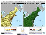
Low Elevation Coastal Zone (LECZ) Global Delta Urban-Rural Population and Land Area Estimates, Version 1
National Aeronautics and Space Administration —
The Low Elevation Coastal Zone (LECZ) Global Delta Urban-Rural Population and Land Area Estimates, Version 1 data set provides country-level estimates of urban,... -
Federal
West Africa Coastal Vulnerability Mapping: Economic Systems Index
National Aeronautics and Space Administration —
The West Africa Coastal Vulnerability Mapping: Economic Systems Index is a composite index based on several spatial indicators, including gridded Gross Domestic... -
Federal
Global High Resolution Daily Extreme Urban Heat Exposure (UHE-Daily), 1983-2016
National Aeronautics and Space Administration —
The Global High Resolution Daily Extreme Urban Heat Exposure (UHE-Daily), 1983-2016 data set contains a high-resolution, longitudinal global record of geolocated... -
Federal
NARSTO PAC2001 NRC-IAR Convair 580 Particle Count, Ozone, Meteorological Data
National Aeronautics and Space Administration —
NARSTO_PAC2001_CONVAIR_PM_OZONE_MET_DATA is the North American Research Strategy for Tropospheric Ozone (NARSTO) Pacific 2001 Air Quality Study (PAC2001) Convair... -
Federal
West Africa Coastal Vulnerability Mapping: Social Vulnerability Indices
National Aeronautics and Space Administration —
The West Africa Coastal Vulnerability Mapping: Social Vulnerability Indices data set includes three indices: Social Vulnerability, Population Exposure, and Poverty... -
Federal
Expandable Variable-Autonomy Architecture Project
National Aeronautics and Space Administration —
Effective multi-level autonomous piloting systems require integration with safety-critical functions. The Expandable Variable-Autonomy... -
Federal
Global One-Eighth Degree Population Base Year and Projection Grids Based on the Shared Socioeconomic Pathways, Revision 01
National Aeronautics and Space Administration —
The Global One-Eighth Degree Population Base Year and Projection Grids Based on the Shared Socioeconomic Pathways, Revision 01, data set consists of global urban,... -
Federal
Annual PM2.5 Concentrations for Countries and Urban Areas, 1998-2016 NGDA
National Aeronautics and Space Administration —
The Annual PM2.5 Concentrations for Countries and Urban Areas, 1998-2016, consists of mean concentrations of particulate matter (PM2.5) for countries and urban areas.... -
Federal
NARSTO PAC2001 Langley Site Gaseous, Particle, and Meteorological Data
National Aeronautics and Space Administration —
NARSTO_PAC2001_LANGLEY_GAS_PM_MET_DATA was obtained between August 8 and September 2, 2001 during the Pacific 2001 Air Quality Study (PAC2001).The Langley Ecole... -
Federal
Global Rural-Urban Mapping Project, Version 1 (GRUMPv1): National Identifier Grid
National Aeronautics and Space Administration —
The Global Rural-Urban Mapping Project, Version 1 (GRUMPv1): National Identifier Grid is derived from the land area grid to create a raster surface where pixels... -
Federal
Global Rural-Urban Mapping Project, Version 1 (GRUMPv1): National Administrative Boundaries
National Aeronautics and Space Administration —
The Global Rural-Urban Mapping Project, Version 1 (GRUMPv1): National Administrative Boundaries are derived from the land area grid to show the outlines of pixels... -
Federal
Global Rural-Urban Mapping Project, Version 1 (GRUMPv1): Settlement Points
National Aeronautics and Space Administration —
The Global Rural-Urban Mapping Project, Version 1 (GRUMPv1): Settlement Points contains geospatial location for selected settlements. This data set is produced by the... -
Federal
Low Elevation Coastal Zone (LECZ) Urban-Rural Population Estimates, Global Rural-Urban Mapping Project (GRUMP), Alpha Version
National Aeronautics and Space Administration —
The Low Elevation Coastal Zone (LECZ) Urban-Rural Population Estimates consists of country-level estimates of urban, rural and total population and land area country-... -
Federal
LBA-ECO LC-01 Landsat TM Land Use/Land Cover, Northern Ecuadorian Amazon: 1986-1999
National Aeronautics and Space Administration —
This data set contains Landsat TM imagery for the years 1986, 1989, 1996, and 1999, that have been classified into four land use/land cover (LULC) classes: Forest,... -
Federal
West Africa Coastal Vulnerability Mapping: Population Projections, 2030 and 2050
National Aeronautics and Space Administration —
The West Africa Coastal Vulnerability Mapping: Population Projections, 2030 and 2050 data set is based on an unreleased working version of the Gridded Population of... -
Federal
NARSTO Supersite Transboundary Intensive Field Study (STIFS) Particulate Matter (PM) Inorganic Volatile Organic Compounds Data
National Aeronautics and Space Administration —
NARSTO_STIFS_CANADA_PM_INORG_VOC_DATA is the North American Research Strategy for Tropospheric Ozone (NARSTO) Supersite Transboundary Intensive Field Study (STIFS)... -
Federal
NARSTO_EPA_SS_ST_LOUIS Air Chemistry, Particulate Matter, Met Data
National Aeronautics and Space Administration —
The NARSTO_EPA_SS_ST_LOUIS_AIR_CHEM_PM_MET_DATA were obtained between April 11, 2001 and July 21, 2003 during the St. Louis - Midwest Supersite program.The overall... -
Federal
China Dimensions Data Collection: Fundamental GIS: Digital Chart of China, 1:1M, Version 1
National Aeronautics and Space Administration —
The Fundamental GIS: Digital Chart of China, 1:1M, Version 1 consists of vector maps of China and surrounding areas. The maps include roads, railroads, drainage... -
Federal
Population Exposure Estimates in Proximity to Nuclear Power Plants, Country-Level Aggregates
National Aeronautics and Space Administration —
The Population Exposure Estimates in Proximity to Nuclear Power Plants, Country-Level Aggregates data set consists of country-level estimates of total, urban, and...

Official websites use .gov
A
.gov website belongs to an official government
organization in the United States.
Secure .gov websites use HTTPS
A
lock (
) or https:// means you’ve safely connected to
the .gov website. Share sensitive information only on official,
secure websites.