
-
Federal
LBA-ECO ND-03 Forest and Pasture Watershed Hydrochemistry, Rondonia, Brazil
National Aeronautics and Space Administration —
This data set consists of water chemistry data from streams, wells, rainwater, and canopy throughfall samples. The field measurements were carried out at Rancho... -
Federal
GLDAS Noah Land Surface Model L4 3 hourly 0.25 x 0.25 degree Early Product V2.1 (GLDAS_NOAH025_3H_EP) at GES DISC
National Aeronautics and Space Administration —
NASA Global Land Data Assimilation System Version 2 (GLDAS-2) has three components: GLDAS-2.0, GLDAS-2.1, and GLDAS-2.2. GLDAS-2.0 is forced entirely with the... -
Federal
IBEX High Energy Neutral Atom Imager (Hi) Data Release 16, Compton-Getting corrected, not Survival Probability corrected, Ram direction, West Longitude Ecliptic Maps, Level H3 (H3), eleven year average Data
National Aeronautics and Space Administration —
1: The Interstellar Boundary Explorer (IBEX) has operated in space since 2008 updating our knowledge of the outer heliosphere and its interaction with the local... -
Federal
GLDAS Noah Land Surface Model L4 monthly 0.25 x 0.25 degree Early Product V2.1 (GLDAS_NOAH025_M_EP) at GES DISC
National Aeronautics and Space Administration —
NASA Global Land Data Assimilation System Version 2 (GLDAS-2) has three components: GLDAS-2.0, GLDAS-2.1, and GLDAS-2.2. GLDAS-2.0 is forced entirely with the... -
Federal
SWOT Level 2 Water Mask Pixel Cloud Data Product, Version D
National Aeronautics and Space Administration —
The SWOT Level 2 Water Mask Pixel Cloud Product (SWOT_L2_HR_PIXC_D) provides high-resolution, geolocated observations of terrestrial surface water pixels detected by... -
Federal
LBA-ECO ND-11 Pre-harvest Forest Tree and Liana Biomass, NW Mato Grosso, Brazil: 2003
National Aeronautics and Space Administration —
The purpose of this study was to determine if spatially-explicit commercial timber inventories (CTI) could be used in conjunction with satellite imagery to improve... -
Federal
SWOT Level 2 Water Mask Pixel Cloud Auxiliary Data Product, Version C
National Aeronautics and Space Administration —
Auxiliary information for pixel cloud product indicating to which water bodies the pixels are assigned in river and lake products. Also includes height-constrained... -
Federal
IBEX High Energy Neutral Atom Imager (Hi) Data Release 04, Compton-Getting corrected, Survival Probability corrected, Omnidirectional, West Longitude Ecliptic Maps, Level H3 (H3), semiannually averaged Data
National Aeronautics and Space Administration —
1: The Interstellar Boundary Explorer (IBEX) has operated in space since 2008 updating our knowledge of the outer heliosphere and its interaction with the local... -
Federal
LBA-ECO ND-03 Stream and Soil Water Data, Fazenda Nova Vida, Rondonia: 1994-2001
National Aeronautics and Space Administration —
This data set provides the results of (1) the physical and chemical characterization of streams and (2) comparable chemical analyses of extracted soil water in the... -
Federal
TROPESS Chemical Reanalysis Ozone 6-Hourly 3-dimensional Product V1 (TRPSCRO36H3D) at GES DISC
National Aeronautics and Space Administration —
The TROPESS Chemical Reanalysis O3 6-Hourly 3-dimensional Product contains vertical concentrations of ozone. The data are part of the Tropospheric Chemical Reanalysis... -
Federal
ASIAS Symposium Presentations
National Aeronautics and Space Administration —
Aviation Safety Information Analysis and Sharing (ASIAS) Symposiusm Presentations: July 27-28, 2009 -
Federal
LBA-ECO CD-06 Flux of CO2 from Amazon Mainstem Rivers, Tributaries, and Floodplains
National Aeronautics and Space Administration —
This data set provides estimates of monthly carbon dioxide (CO2) flux from the Amazon mainstem rivers, tributary stream networks, and their associated varzeas... -
Federal
LBA-ECO CD-06 Physical, Political, and Hydrologic Maps, Ji-Parana River Basin, Brazil
National Aeronautics and Space Administration —
This data set contains physical, hydrologic, political, demographic, and societal maps for the Ji-Parana River Basin, in the state of Rondonia, Brazil. These data... -
Federal
LBA-ECO CD-06 Amazon River Basin Land and Stream Drainage Direction Maps
National Aeronautics and Space Administration —
This data set provides high-resolution (~500 m) gridded land and stream drainage direction maps for the Amazon River basin, excluding the Rio Tocantins basin. These... -
Federal
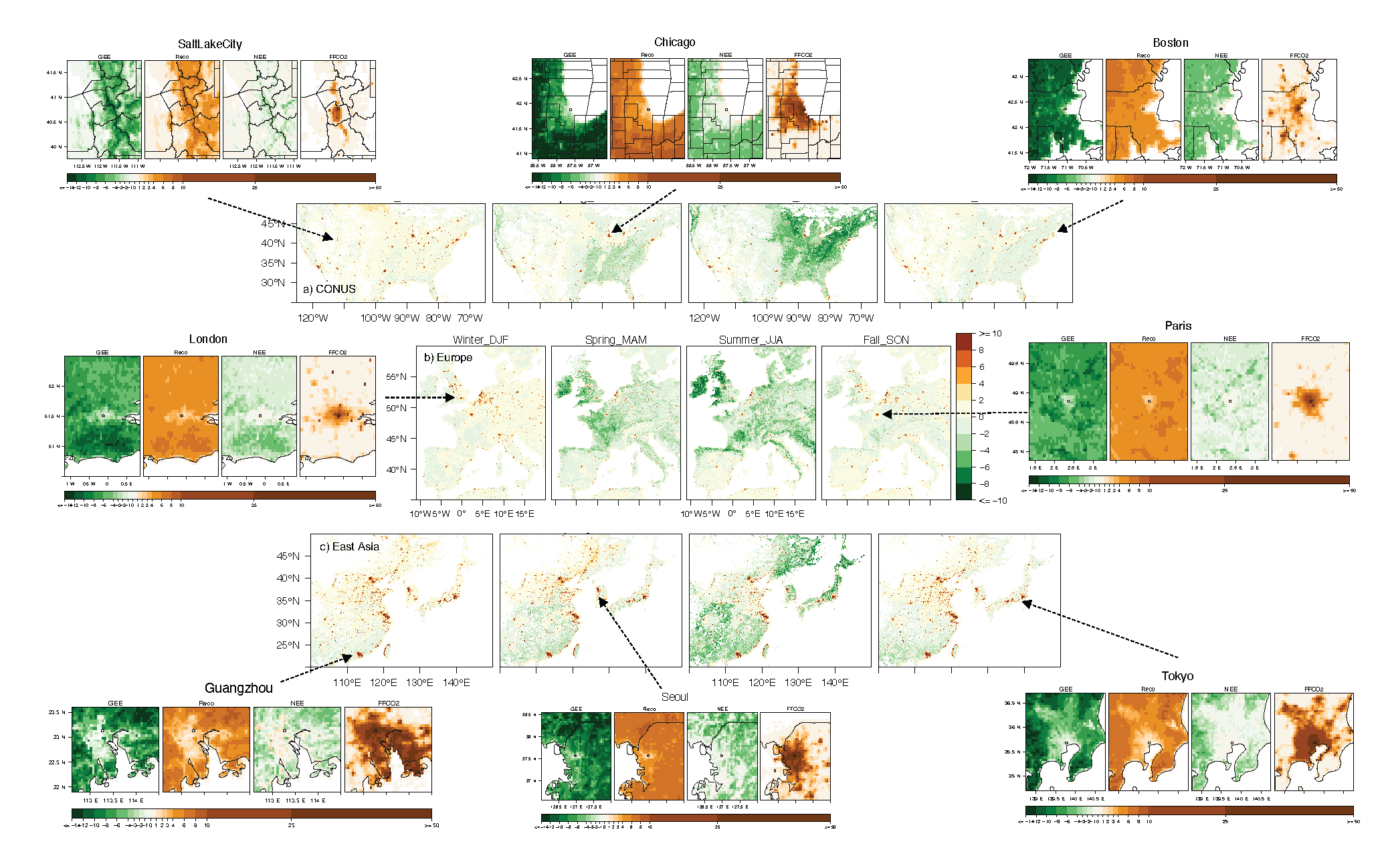
Urban Biogenic CO2 fluxes: GPP, Reco and NEE Estimates from SMUrF, 2010-2019
National Aeronautics and Space Administration —
This dataset contains estimates of biogenic CO2 flux components at 0.05 degree resolution from the Solar-Induced Fluorescence (SIF) for Modeling Urban biogenic Fluxes... -
Federal
THIR/Nimbus-7 Level 1 Calibrated Located Radiation Data at 6.7 and 11.5 microns V001 (THIRN7L1CLDT) at GES DISC
National Aeronautics and Space Administration —
THIRN7L1CLDT is the Nimbus-7 Temperature-Humidity Infrared Radiometer (THIR) Level 1 Calibrated Located Radiation Data (CLDT) at 6.7 and 11.5 microns product and... -
Federal
SWOT Level 2 Lake Single-Pass Vector Data Product, Version C
National Aeronautics and Space Administration —
The SWOT Level 2 Lake Single-Pass Vector Data Product from the Surface Water Ocean Topography (SWOT) mission provides water surface elevation, area, storage change... -
Federal
Stream Flow Storm Data (FIFE)
National Aeronautics and Space Administration —
The Storm Event Stream Flow Data Set were collected during storm events from five treatment areas within the Konza Prairie Long-Term Ecological Research (LTER) site... -
Federal
GPM Ground Validation Iowa Flood Center (IFC) Stream Flow IFloodS V1
National Aeronautics and Space Administration —
The GPM Ground Validation Iowa Flood Center (IFC) Stream Flow IFloodS dataset was obtained from the IFC during the Iowa Flood Studies (IFloodS) field campaign that... -
Federal
ASTER L1A Reconstructed Unprocessed Instrument Data V003
National Aeronautics and Space Administration —
The Advanced Spaceborne Thermal Emission and Reflection Radiometer (ASTER) Level 1A (AST_L1A) contains reconstructed, instrument digital numbers (DNs) derived from...

Official websites use .gov
A
.gov website belongs to an official government
organization in the United States.
Secure .gov websites use HTTPS
A
lock (
) or https:// means you’ve safely connected to
the .gov website. Share sensitive information only on official,
secure websites.