
-
Federal
NASA Thesaurus
National Aeronautics and Space Administration —
The NASA Thesaurus contains the authorized NASA subject terms used to index and retrieve materials in the NASA Technical Reports Server (NTRS) and the NTRS Registered... -
Federal
SWOT Level 2 River Single-Pass Vector Data Product, Version D
National Aeronautics and Space Administration —
The SWOT Level 2 River Single-Pass Vector Data Product (SWOT_L2_HR_RiverSP_D) provides hydrologic measurements for predefined river reaches and nodes, derived from... -
Federal
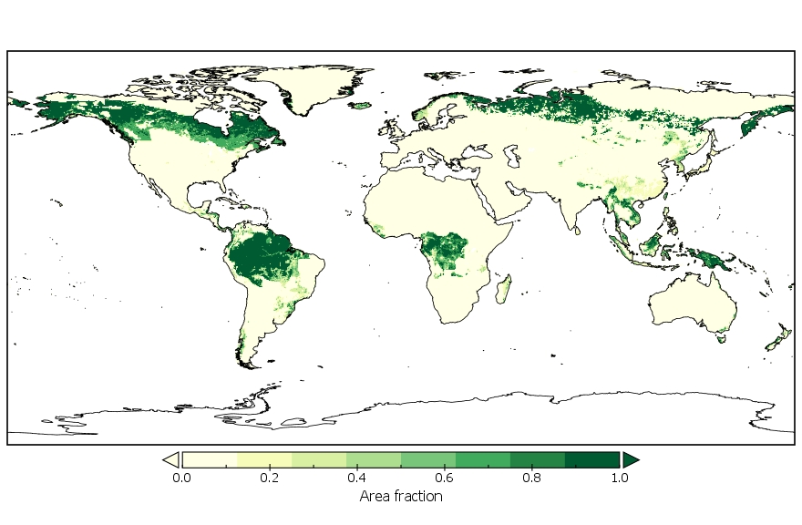
Global Land Cover Mapping and Estimation Yearly 30 m V001
National Aeronautics and Space Administration —
NASA's Making Earth System Data Records for Use in Research Environments (MEaSUREs) Global Land Cover Mapping and Estimation (GLanCE) annual 30 meter (m) Version 1... -
Federal
Global Pesticide Grids (PEST-CHEMGRIDS), Version 1.01
National Aeronautics and Space Administration —
The Global Pesticide Grids (PEST-CHEMGRIDS), Version 1.01 data set contains 20 of the most-used pesticide active ingredients on 6 dominant crops and 4 aggregated crop... -
Federal
Uppsala General Catalog of Galaxies
National Aeronautics and Space Administration —
The Uppsala General Catalogue of Galaxies (UGC) is an essentially complete catalog of galaxies to a limiting diameter of 1.0 arcminute and/or to a limiting apparent... -
Federal
LUH2-GCB2019: Land-Use Harmonization 2 Update for the Global Carbon Budget, 850-2019
National Aeronautics and Space Administration —
This dataset, referred to as LUH2-GCB2019, includes 0.25-degree gridded, global maps of fractional land-use states, transitions, and management practices for the... -
Federal
International Ice Patrol (IIP) Iceberg Sightings Database, Version 1
National Aeronautics and Space Administration —
The International Ice Patrol (IIP) has been collecting information on iceberg activity in the North Atlantic since 1913. This database contains the data from these... -
Federal
International Ice Patrol Annual North Atlantic Iceberg Summaries and Reports, Version 1
National Aeronautics and Space Administration —
The International Ice Patrol (IIP) has been monitoring iceberg activity in the North Atlantic since 1913. This data set contains yearly summaries and reports of these... -
Federal
Northern Circumpolar Soils Map, Version 1
National Aeronautics and Space Administration —
This data set consists of a circumpolar map of dominant soil characteristics, with a scale of 1:10,000,000, covering the United States, Canada, Greenland, Iceland,... -
Federal
NARSTO EPA_SS_HOUSTON TEXAQS2000 Particulate Matter FTIR Composition
National Aeronautics and Space Administration —
The NARSTO_EPA_SS_HOUSTON_TEXAQS2000_PM_FTIR measurement data consist of absolute absorbance areas for organonitrates, sulfate, aliphatic carbon and carbonyl... -
Federal
Regridded Harmonized World Soil Database v1.2
National Aeronautics and Space Administration —
This data set describes select global soil parameters from the Harmonized World Soil Database (HWSD) v1.2, including additional calculated parameters such as area... -
Federal
Global Forest Ecosystem Structure and Function Data For Carbon Balance Research
National Aeronautics and Space Administration —
A comprehensive global database has been assembled to quantify CO2 fluxes and pathways across different levels of integration (from photosynthesis up to net ecosystem... -
Federal
VERITAS Source Catalog
National Aeronautics and Space Administration —
The Very Energetic Radiation Imaging Telescope Array System (VERITAS) is a major ground-based gamma-ray observatory operating at the Fred Lawrence Whipple Observatory... -
Federal
eROSITA eFEDS Hard X-Ray (2.3-5.0 keV) Source Catalog
National Aeronautics and Space Administration —
The eROSITA X-ray telescope on board the Spectrum-Roentgen-Gamma (SRG) observatory combines a large field of view and collecting area in the energy range ~0.2 to ~8.0... -
Federal
LBA Regional Organic Soil Carbon and Nitrogen Data (Zinke et al.)
National Aeronautics and Space Administration —
The data set contains a subset of a global organic soil carbon and nitrogen data set (Zinke et al. 1986). The subset was created for the study area of the Large Scale... -
Federal
LISTOS Stony Brook Aircraft In-Situ Data
National Aeronautics and Space Administration —
LISTOS_AircraftInSitu_StonyBrookAircraft_Data is the Long Island Sound Tropospheric Ozone Study (LISTOS) in-situ data collected onboard the Stony Brook Aircraft... -
Federal
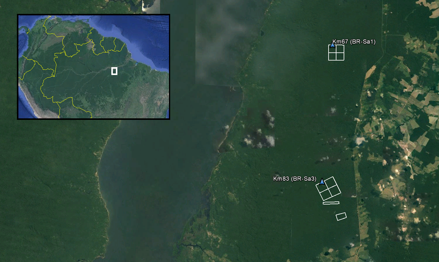
LiDAR and DTM Data from Tapajos National Forest in Para, Brazil, 2008
National Aeronautics and Space Administration —
This data set provides LiDAR point clouds and digital terrain models (DTM) from surveys over the Tapajos National Forest in Belterra municipality, Para, Brazil during... -
Federal
LBA Regional Derived Soil Properties, 0.5-Deg (ISRIC-WISE)
National Aeronautics and Space Administration —
The data set consists of a subset of the ISRIC-WISE global data set of derived soil properties for the study area of the Large Scale Biosphere-Atmosphere Experiment... -
Federal
LBA Regional Freshwater Wetlands, 1-Degree (Stillwell-Soller et al.)
National Aeronautics and Space Administration —
This data set consists of a subset of a 1-degree gridded global freshwater wetlands database (Stillwell-Soller et al. 1995). This subset was created for the study... -
Federal
Gridded GEDI Vegetation Structure Metrics and Biomass Density at Multiple Resolutions
National Aeronautics and Space Administration —
This dataset consists of near-global, analysis-ready, multi-resolution gridded vegetation structure metrics derived from NASA Global Ecosystem Dynamics Investigation...

Official websites use .gov
A
.gov website belongs to an official government
organization in the United States.
Secure .gov websites use HTTPS
A
lock (
) or https:// means you’ve safely connected to
the .gov website. Share sensitive information only on official,
secure websites.