
-
Federal
Vulcan: High-Resolution Hourly Fossil Fuel CO2 Emissions in USA, 2010-2015, Version 3
National Aeronautics and Space Administration —
The Vulcan version 3.0 hourly dataset quantifies hourly emissions at a 1-km resolution for the 2010-2015 time period. Estimates are provided of hourly carbon dioxide... -
Federal
GPM GROUND VALIDATION TWO-DIMENSIONAL VIDEO DISDROMETER (2DVD) MC3E V1
National Aeronautics and Space Administration —
The GPM Ground Validation Two-Dimensional Video Disdrometer (2DVD) MC3E dataset was collected during the Midlatitude Continental Convective Clouds Experiment (MC3E),... -
Federal
Last of the Wild Project, Version 2, 2005 (LWP-2): Global Human Influence Index (HII) Dataset (IGHP)
National Aeronautics and Space Administration —
The Global Human Influence Index Dataset of the Last of the Wild Project, Version 2, 2005 (LWP-2) is a global dataset of 1-kilometer grid cells, created from nine... -
Federal
GPM GROUND VALIDATION AUTONOMOUS PARSIVEL UNIT (APU) MC3E V1
National Aeronautics and Space Administration —
The GPM Ground Validation Autonomous Parsivel Unit (APU) MC3E dataset was collected by the Autonomous Parsivel Unit (APU), which is an optical disdrometer that... -
Federal
The NASA Air Traffic Management Ontology (atmonto)
National Aeronautics and Space Administration —
The NASA ATM (Air Traffic Management) Ontology describes classes, properties, and relationships relevant to the domain of air traffic management, and represents... -
Federal
SDG Indicator 7.1.1: Access to Electricity, 2023 Release
National Aeronautics and Space Administration —
The SDG Indicator 7.1.1: Access to Electricity, 2023 Release data set, part of the Sustainable Development Goal Indicators (SDGI) collection, measures the proportion... -
Federal
Randolph Glacier Inventory - A Dataset of Global Glacier Outlines, Version 3
National Aeronautics and Space Administration —
The Randolph Glacier Inventory (RGI) is a global set of glacier outlines; it is intended as a snapshot of the world’s glaciers. This data set provides a single... -
Federal
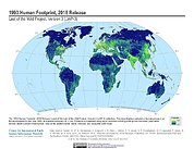
Last of the Wild Project, Version 3 (LWP-3): 1993 Human Footprint, 2018 Release
National Aeronautics and Space Administration —
The 1993 Human Footprint, 2018 Release provides a global map of the cumulative human pressure on the environment in 1993, at a spatial resolution of ~1 km. The human... -
Federal
Sources of Methane Emissions (Vista-LA), South Coast Air Basin, California, USA
National Aeronautics and Space Administration —
This data set provides spatial data products with identified and classified locations of potential methane (CH4) emitting facilities and infrastructure in the South... -
Federal
Last of the Wild Project, Version 1, 2002 (LWP-1): Global Human Footprint Dataset (IGHP)
National Aeronautics and Space Administration —
The Global Human Footprint Dataset of the Last of the Wild Project, Version 1, 2002 (LWP-1) is the Human Influence Index (HII) normalized by biome and realm. The HII... -
Federal
USGS Group on Earth Observations (GEO) Global Agricultural Monitoring (GLAM) Algeria
National Aeronautics and Space Administration —
The objective of GEO is to fulfil a vision of a world where decisions and actions are informed by coordinated, comprehensive and sustained Earth Observation (EO).... -
Federal
West Africa Coastal Vulnerability Mapping: Subset of OpenStreetMap (OSM) Roads
National Aeronautics and Space Administration —
The West Africa Coastal Vulnerability Mapping: Subset of OpenStreetMap (OSM) Roads data set includes roads within 200 kilometers of the coast and was extracted from... -
Federal
General Mission Analysis Tool Project
National Aeronautics and Space Administration —
Overview GMAT is a feature rich system containing high fidelity space system models, optimization and targeting,built in scripting and programming infrastructure, and... -
Federal
South-East Asian Region (SEAR): Sea Basin Landscape Mapping for Paleoclimatology & Recent Climate Change Impacts
National Aeronautics and Space Administration —
The objective of this work includes the coastal scenario, risks and development of coastal paleoclimatology through landscape mapping; by highlighting the devastating... -
Federal
AMSRIce03 Sea Ice Thickness Data, Version 1
National Aeronautics and Space Administration —
Notice to Data Users: The documentation for this data set was provided solely by the Principal Investigator(s) and was not further developed, thoroughly reviewed, or... -
Federal
USGS Group on Earth Observations (GEO) Global Agricultural Monitoring (GLAM) Ethiopia
National Aeronautics and Space Administration —
The objective of GEO is to fulfil a vision of a world where decisions and actions are informed by coordinated, comprehensive and sustained Earth Observation (EO).... -
Federal
LBA-ECO CD-06 Physical, Political, and Hydrologic Maps, Ji-Parana River Basin, Brazil
National Aeronautics and Space Administration —
This data set contains physical, hydrologic, political, demographic, and societal maps for the Ji-Parana River Basin, in the state of Rondonia, Brazil. These data... -
Federal
Global Inventory of Methane Emissions from Fuel Exploitation V1 (GFEI_CH4)
National Aeronautics and Space Administration —
This is a global inventory of methane emissions from fuel exploitation (GFEI) created for the NASA Carbon Monitoring System (CMS). The emission sources represented in... -
Federal
Archive of Census Related Products (ACRP): 1990 Street Intersections
National Aeronautics and Space Administration —
The 1990 Street Intersections portion of the Archive of Census Related Products (ACRP) contains the latitude and longitude of street intersections for each county in...

Official websites use .gov
A
.gov website belongs to an official government
organization in the United States.
Secure .gov websites use HTTPS
A
lock (
) or https:// means you’ve safely connected to
the .gov website. Share sensitive information only on official,
secure websites.