
-
Federal
MISR Level 3 Global Cloud public Product in netCDF format covering a day V002
National Aeronautics and Space Administration —
MI3DCLDN_2 is the Multi-angle Imaging SpectroRadiometer (MISR) Level 3 Global Cloud public Product in netCDF format covering a day version 2. It contains the public... -
Federal
BARREL 1I X-ray Spectrometer (MSPC) Bremsstrahlung X-ray Spectrum Medium Time Resolution, Level 2, 4 s Data
National Aeronautics and Space Administration —
MSPC: 48 channels of medium time resolution, 4 s, Bremsstrahlung X-ray spectra detected with a NaI Scintillator. The nominal energy range covered by the 48 channels... -
Federal
MISR L2 Aerosol Product subset for the ICARTT region V002
National Aeronautics and Space Administration —
CARMIAAE_002 is the MISR L2 Aerosol Product subset for the ICARTT region V002 product. It contains aerosol optical depth and particle type, with associated... -
Federal
MISR Geometric Parameters V003
National Aeronautics and Space Administration —
MIB2GEOP_003 is the Multi-angle Imaging SpectroRadiometer (MISR) Geometric Parameters Version 3 product. It contains the Geometric Parameters which measure the sun... -
Federal
Mean Annual Fluxes of Carbon in Coastal Ecosystems of Eastern North America
National Aeronautics and Space Administration —
This dataset contains best estimates and uncertainties for mean annual fluxes of inorganic, organic, and total (organic + inorganic) carbon in tidal wetlands,... -
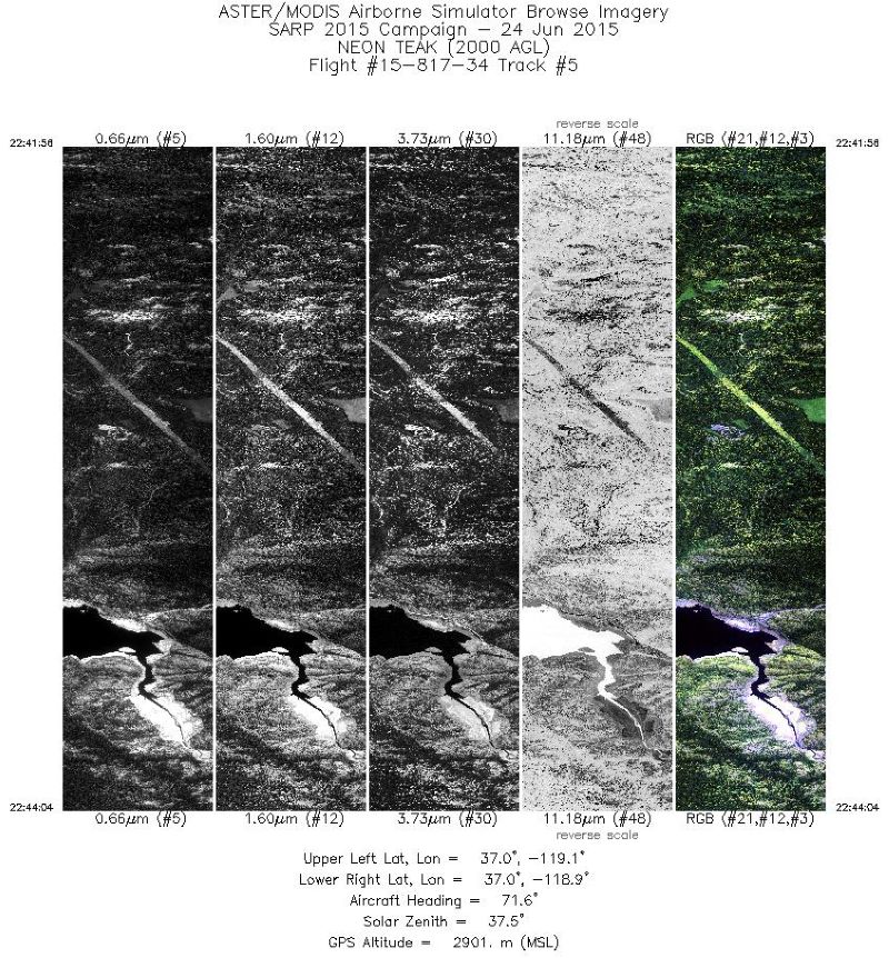
Federal
MASTER: HyspIRI Airborne Campaign, California, Early Spring 2013, V2
National Aeronautics and Space Administration —
This dataset includes Level 1B (L1B) and Level 2 (L2) data products from the MODIS/ASTER Airborne Simulator (MASTER) instrument. The spectral data were collected as... -
Federal
LBA-ECO LC-01 Landsat MSS, TM, ETM+ Imagery, Northern Ecuadorian Amazon: 1973-2002
National Aeronautics and Space Administration —
This data set contains a time series of early Landsat-4 MSS satellite imagery as well as Landsat-5 TM and Landsat-7 ETM+ satellite imagery of the northern Ecuadorian... -
Federal
LBA-ECO CD-37 Secondary Forest Biomass and Age Class, Rondonia, Brazil
National Aeronautics and Space Administration —
This data set provides tree age, forest formation, and land cover classification maps, and estimates of landscape-level above-ground live woody biomass (AGLB) for... -
Federal
LBA-ECO CD-04 Soil Moisture Data, km 83 Tower Site, Tapajos National Forest, Brazil
National Aeronautics and Space Administration —
This data set reports continuous high-resolution frequency-domain reflectometry measurements of soil moisture to 10 m depth and precipitation data near each of the... -
Federal
JERS-1 Synthetic Aperture Radar, 100-m Mosaics, South America: 1995-1996, R1
National Aeronautics and Space Administration —
This data set provides ~100-m resolution image mosaics of South America acquired during the low flood season between September and December 1995 and during the high... -
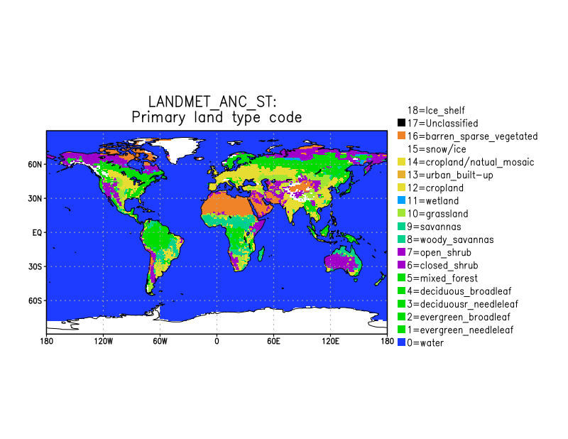
Federal
LANDMET Ancillary ISCCP Surface Type Data L3 V1 (LANDMET_ANC_ST) at GES DISC
National Aeronautics and Space Administration —
This is an ancillary product containing the land surface type information includes, for each map grid cell, the type and coverage fractions of the top three surface... -
Federal
ABoVE: Soil Temperature Profiles, USArray Seismic Stations, AK and Canada, 2016-2019
National Aeronautics and Space Administration —
This dataset includes soil temperature profile measurements taken at 16 monitoring sites in Alaska, USA, and at one site in Yukon, Canada. The six sites are... -
Federal
ABoVE: Post-Fire and Unburned Vegetation Community and Field Data, NWT, Canada, 2019
National Aeronautics and Space Administration —
This dataset provides vegetation community characteristics, soil moisture, and biophysical data collected in 2019 from 11 study areas, which contained 28 sites that... -
Federal
BARREL 2W Data Processing Unit (HKPG) Analog Housekeeping Voltage, Temperature, Current, and Payload Status, Level 2, 40 s Data
National Aeronautics and Space Administration —
Housekeeping voltage, temperature, current, and payload status values returned every 40 s. NOTE: The analog sensor data in these records are based on the nominal... -
Federal
BARREL 2O X-ray Spectrometer (FSPC) Bremsstrahlung X-ray Spectrum Fast Time Resolution, Level 2, 0.05 s Data
National Aeronautics and Space Administration —
FSPC: Six channels of fast time resolution, 50 ms, Bremsstrahlung X-ray spectra detected with a NaI Scintillator. Each channel is separated in its own variable:... -
Federal
BARREL 2Y X-ray Spectrometer (FSPC) Bremsstrahlung X-ray Spectrum Fast Time Resolution, Level 2, 0.05 s Data
National Aeronautics and Space Administration —
FSPC: Six channels of fast time resolution, 50 ms, Bremsstrahlung X-ray spectra detected with a NaI Scintillator. Each channel is separated in its own variable:... -
Federal
BARREL 1K Data Processing Unit (HKPG) Analog Housekeeping Voltage, Temperature, Current, and Payload Status, Level 2, 40 s Data
National Aeronautics and Space Administration —
Housekeeping voltage, temperature, current, and payload status values returned every 40 s. NOTE: The analog sensor data in these records are based on the nominal... -
Federal
BARREL 1U Rate Counter (RCNT) NaI Scintillator Diagnostics, Level 2, 4 s Data
National Aeronautics and Space Administration —
This data product consists of measurements from rate counters. The rate count data are diagnostic fields, have uncalibrated energy ranges, and wrap near or above... -
Federal
OMG Glacial Elevations from GLISTIN-A Ver. 1
National Aeronautics and Space Administration —
This dataset contains 50m horizontal resolution gridded digital elevation models (DEMs) of Greenland Ice Sheet outlet glaciers collected during the NASA Oceans... -
Federal
MODIS/Terra+Aqua BRDF/Albedo Parameter2 Band2 Daily L3 Global 30ArcSec CMG V006
National Aeronautics and Space Administration —
The MCD43D05 Version 6 data product was decommissioned on July 31, 2023. Users are encouraged to use the MCD43D05 Version 6.1 data product.The MCD43D05 Version 6...

Official websites use .gov
A
.gov website belongs to an official government
organization in the United States.
Secure .gov websites use HTTPS
A
lock (
) or https:// means you’ve safely connected to
the .gov website. Share sensitive information only on official,
secure websites.