
-
Federal
BOREAS Level-1B MAS Imagery: At-Sensor Radiance, Relative X and Y Coordinates
National Aeronautics and Space Administration —
For BOREAS, the MAS images, along with the other remotely sensed data, were collected to provide spatially-extensive information over the primary study areas. This... -
Federal
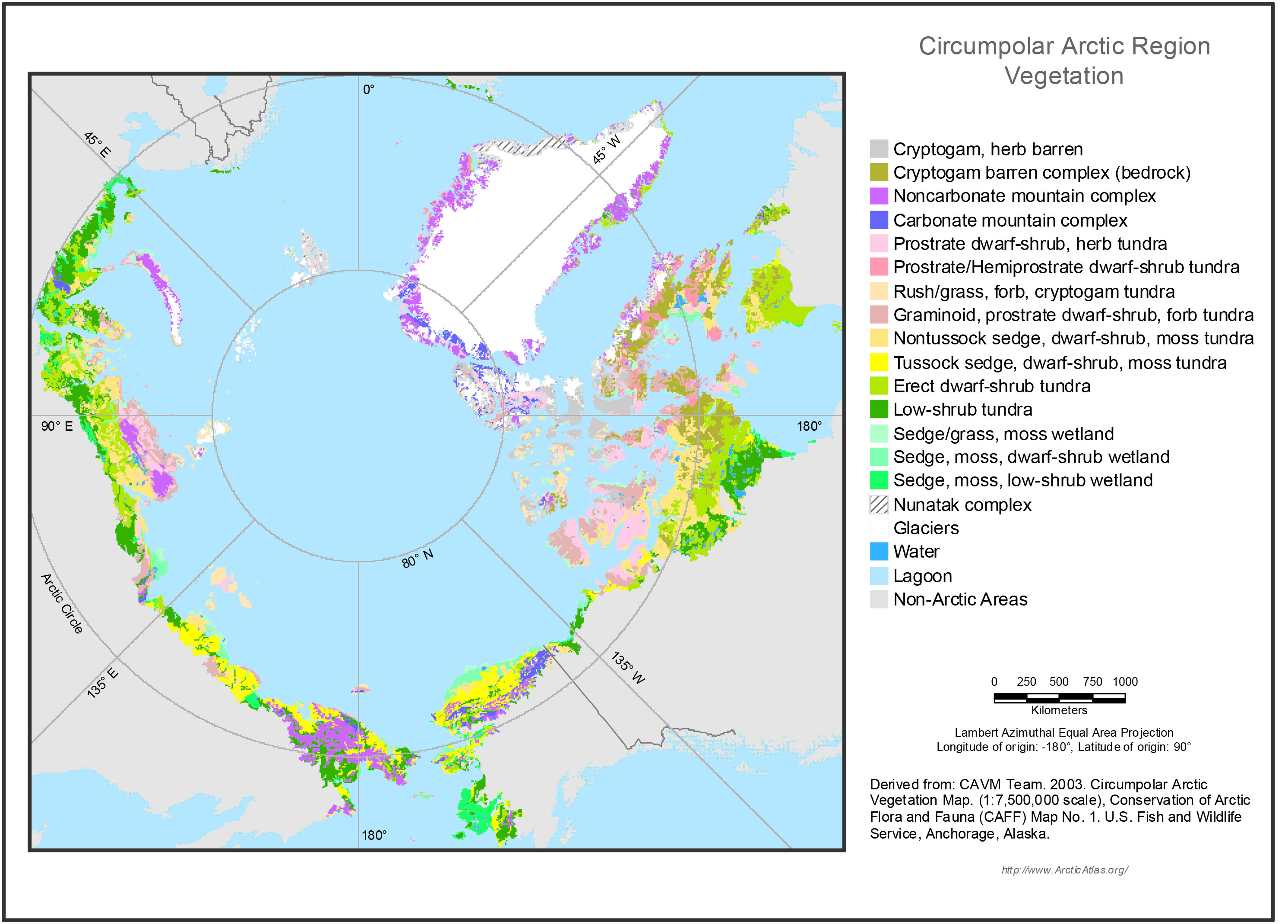
Circumpolar Arctic Vegetation, Geobotanical, Physiographic Maps, 1982-2003
National Aeronautics and Space Administration —
This data set provides the spatial distributions of vegetation types, geobotanical characteristics, and physiographic features for the circumpolar Arctic tundra biome... -
Federal
Seasonal frost depths, midwestern USA, Version 1
National Aeronautics and Space Administration —
This dataset includes frost tube data from 37 stations in the Upper Midwest (Minnesota, North Dakota, Wisconsin), USA. The responsible agency was the St. Paul... -
Federal
MODIS/Aqua Land Surface Temperature/Emissivity 8-Day L3 Global 0.05Deg CMG V006
National Aeronautics and Space Administration —
The MYD11C2 Version 6 data product was decommissioned on July 31, 2023. Users are encouraged to use the MYD11C2 Version 6.1 data product.The MYD11C2 Version 6 product... -
Federal
MODIS Terra Level 3 SST MID-IR Daily 9km Nighttime V2019.0
National Aeronautics and Space Administration —
Day and night spatially gridded (L3) global NASA skin sea surface temperature (SST) products from the Moderate-resolution Imaging Spectroradiometer (MODIS) onboard... -
Federal
GEWEX SRB Integrated Product (Rel-4) Ancillary 3-Hourly
National Aeronautics and Space Administration —
GEWEX SRB Integrated Product (Rel-4) Ancillary 3-Hourly contains the global fields of meteorology, clouds and other ancillary data that serves as the inputs to the... -
Federal
CARVE: Fire-Related Aerosol and Soil Elemental and Isotopic Composition, Alaska, 2013
National Aeronautics and Space Administration —
This data set provides measurements of the isotopic composition of black carbon and organic carbon aerosols collected at two locations in interior Alaska during the... -
Federal
CARVE: Monthly Atmospheric CO2 Concentrations (2009-2013) and Modeled Fluxes, Alaska
National Aeronautics and Space Administration —
This data set reports monthly averages of atmospheric CO2 concentration from satellite and airborne observations between 2009 and 2013 and simulated present and... -
Federal
VIIRS/NPP BRDF/Albedo BSA at Solar Noon Band M4 Daily L3 Global 30ArcSec CMG V001
National Aeronautics and Space Administration —
The VNP43D57 Version 1 data product was decommissioned on July 31, 2025. Users are encouraged to use the VNP43D57 and VJ143D57 Version 2 data products.The NASA/NOAA... -
Federal
VIIRS/NPP BRDF/Albedo Albedo Daily L3 Global 1km SIN Grid V001
National Aeronautics and Space Administration —
The VNP43MA3 Version 1 data product was decommissioned on July 31, 2025. Users are encouraged to use the VNP43MA3 and VJ143MA3 Version 2 data products.The NASA/NOAA... -
Federal
VIIRS/NPP BRDF/Albedo Albedo Daily L3 Global 0.05Deg CMG V002
National Aeronautics and Space Administration —
The NASA/NOAA Suomi National Polar-orbiting Partnership (Suomi NPP) Visible Infrared Imaging Radiometer Suite (VIIRS) Bidirectional Reflectance Distribution Function... -
Federal
VIIRS/NPP Thermal Anomalies/Fire 6-Min L2 Swath 750m V002
National Aeronautics and Space Administration —
The Visible Infrared Imaging Radiometer Suite (VIIRS) Thermal Anomalies (VNP14) Version 2 product is produced in 6-minute temporal satellite increments (swaths) at... -
Federal
VIIRS/NPP BRDF/Albedo BSA at Solar Noon ShortWave Daily L3 Global 30ArcSec CMG V001
National Aeronautics and Space Administration —
The VNP43D65 Version 1 data product was decommissioned on July 31, 2025. Users are encouraged to use the VNP43D65 and VJ143D65 Version 2 data products.The NASA/NOAA... -
Federal
VIIRS/NPP BRDF/Albedo Model Parameters Daily L3 Global 1km SIN Grid V001
National Aeronautics and Space Administration —
The VNP43MA1 Version 1 data product was decommissioned on July 31, 2025. Users are encouraged to use the VNP43MA1 and VJ143MA1 Version 2 data products.The NASA/NOAA... -
Federal
VIIRS/NPP BRDF/Albedo Parameter 1 Band M5 Daily L3 Global 30 ArcSec CMG V002
National Aeronautics and Space Administration —
The NASA/NOAA Suomi National Polar-orbiting Partnership (Suomi NPP) Visible Infrared Imaging Radiometer Suite (VIIRS) Bidirectional Reflectance Distribution Function... -
Federal
VIIRS/NPP BRDF/Albedo Parameter 2 Band M10 Daily L3 Global 30 ArcSec CMG V002
National Aeronautics and Space Administration —
The NASA/NOAA Suomi National Polar-orbiting Partnership (Suomi NPP) Visible Infrared Imaging Radiometer Suite (VIIRS) Bidirectional Reflectance Distribution Function... -
Federal
VIIRS/NPP BRDF/Albedo Parameter 2 Band M2 Daily L3 Global 30 ArcSec CMG V001
National Aeronautics and Space Administration —
The VNP43D05 Version 1 data product was decommissioned on July 31, 2025. Users are encouraged to use the VNP43D05 and VJ143D05 Version 2 data products.The NASA/NOAA... -
Federal
VIIRS/NPP BRDF/Albedo NBAR at Solar Noon Band M8 Daily L3 Global 30ArcSec CMG V001
National Aeronautics and Space Administration —
The VNP43D86 Version 1 data product was decommissioned on July 31, 2025. Users are encouraged to use the VNP43D86 and VJ143D86 Version 2 data products.The NASA/NOAA... -
Federal
MISR Level 1B1 Local Mode Radiance Data V002
National Aeronautics and Space Administration —
MIB1LM_002 is the Multi-angle Imaging SpectroRadiometer (MISR) Level 1B1 Local Mode Radiance Data version 2. It contains the data numbers (DNs) radiometrically scaled...

Official websites use .gov
A
.gov website belongs to an official government
organization in the United States.
Secure .gov websites use HTTPS
A
lock (
) or https:// means you’ve safely connected to
the .gov website. Share sensitive information only on official,
secure websites.