
-
Federal
GPM GROUND VALIDATION COMPOSITE SATELLITE OVERPASSES MC3E V1
National Aeronautics and Space Administration —
The GPM Ground Validation Composite Satellite Overpasses MC3E dataset provides satellite overpasses from the AQUA satellite during the Midlatitude Continental... -
Federal
Gross Primary Production Maps of Tidal Wetlands across Conterminous USA, 2000-2019
National Aeronautics and Space Administration —
This dataset provides mapped tidal wetland gross primary production (GPP) estimates (g C/m2/day) derived from multiple wetland types at 250-m resolution across the... -
Federal
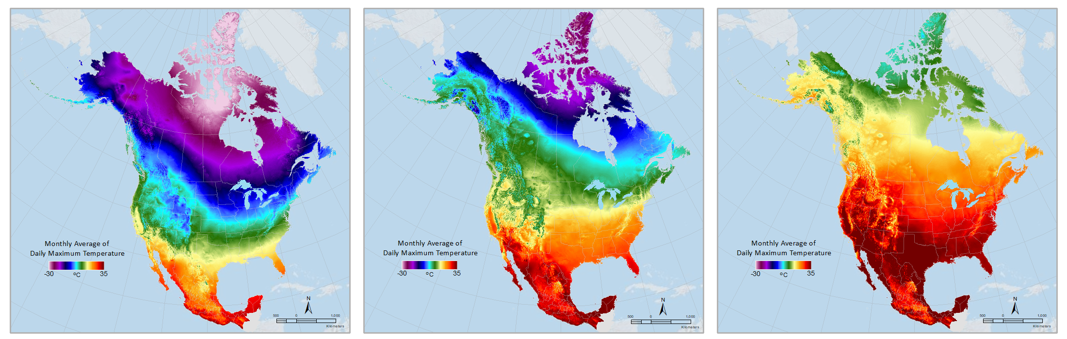
Daymet: Monthly Climate Summaries on a 1-km Grid for North America, Version 4 R1
National Aeronautics and Space Administration —
This dataset provides Daymet Version 4 R1 monthly climate summaries derived from Daymet Version 4 R1 daily data at a 1 km x 1 km spatial resolution for five Daymet... -
Federal
BOREAS RSS-14 GOES-7 Level-1 Visible, Infrared, and Water Vapor Images
National Aeronautics and Space Administration —
The level-1 BOREAS GOES-7 image data were collected by Remote Sensing Science Team 14 (RSS-14) personnel at Florida State University (FSU) and delivered to BORIS. The... -
Federal
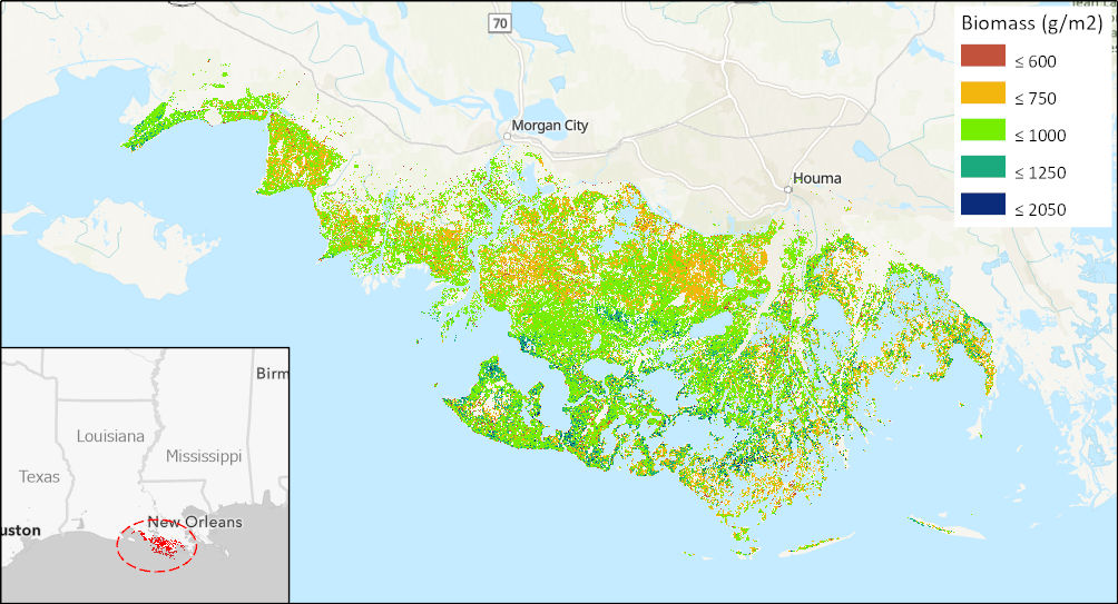
Aboveground Biomass High-Resolution Maps for Selected US Tidal Marshes, 2015
National Aeronautics and Space Administration —
This dataset provides maps of aboveground tidal marsh biomass (g/m2) at 30 m resolution for six estuarine regions of the conterminous United States: Cape Cod, MA;... -
Federal
BOREAS TF-10 NSA-YJP Tower Flux, Meteorological, and Porometry Data
National Aeronautics and Space Administration —
The BOREAS TF-10 team collected tower flux and meteorological data at two sites, a fen and a young jack pine forest, near Thompson, Manitoba, Canada, as part of... -
Federal
Arctic Vegetation Plots Legacy Project Barter Island and Point Barrow, Alaska, 1994
National Aeronautics and Space Administration —
This dataset provides vegetation cover and environmental plot and soil data collected at two U.S. Air Force sites at Barter Island (BI) and Point Barrow (B), on the... -
Federal
ARISE 2014 C-130 In-Situ Cloud Data
National Aeronautics and Space Administration —
ARISE_Cloud_AircraftInSitu_C130_Data_1 is the Arctic Radiation - IceBridge Sea & Ice Experiment (ARISE) 2014 in-situ cloud data product. This product is a result... -
Federal
BOREAS HYD-04 Standard Snow Course Data
National Aeronautics and Space Administration —
The BOREAS HYD-04 work was focused on collecting data during the winter field campaign (FFC-W) to improve the understanding of winter processes within the boreal... -
Federal
SCOAPE Pandora Column Observations
National Aeronautics and Space Administration —
SCOAPE_Pandora_Data is the column NO2 and ozone data collected by Pandora spectrometers during the Satellite Coastal and Oceanic Atmospheric Pollution Experiment... -
Federal
SCOAPE Ground Site Data
National Aeronautics and Space Administration —
SCOAPE_Ground_Data is the ground site data collected during the Satellite Coastal and Oceanic Atmospheric Pollution Experiment (SCOAPE). The ground site was located... -
Federal
GLDAS Catchment Land Surface Model L4 3 hourly 1.0 x 1.0 degree V2.0 (GLDAS_CLSM10_3H) at GES DISC
National Aeronautics and Space Administration —
NASA Global Land Data Assimilation System Version 2 (GLDAS-2) has three components: GLDAS-2.0, GLDAS-2.1, and GLDAS-2.2. GLDAS-2.0 is forced entirely with the... -
Federal
ECCO Geometry Parameters for the Lat-Lon-Cap 90 (llc90) Native Model Grid (Version 4 Release 4)
National Aeronautics and Space Administration —
This dataset provides geometric parameters for the lat-lon-cap 90 (llc90) native model grid from the ECCO Version 4 Release 4 (V4r4) ocean and sea-ice state estimate.... -
Federal
ECCO Geometry Parameters for the 0.5 degree Lat-Lon Model Grid (Version 4 Release 4)
National Aeronautics and Space Administration —
This dataset provides geometric parameters for the regular 0.5-degree lat-lon grid from the ECCO Version 4 Release 4 (V4r4) ocean and sea-ice state estimate.... -
Federal
GLDAS VIC Land Surface Model L4 3 hourly 1.0 x 1.0 degree V2.0 (GLDAS_VIC10_3H) at GES DISC
National Aeronautics and Space Administration —
NASA Global Land Data Assimilation System Version 2 (GLDAS-2) has three components: GLDAS-2.0, GLDAS-2.1, and GLDAS-2.2. GLDAS-2.0 is forced entirely with the... -
Federal
FLDAS Noah Land Surface Model L4 Global Monthly 0.1 x 0.1 degree (GDAS and CHIRPS-PRELIM) V001 (FLDAS_NOAH01_CP_GL_M) at GES DISC
National Aeronautics and Space Administration —
This dataset contains a series of land surface parameters simulated from the Noah 3.6.1 model in the Famine Early Warning Systems Network (FEWS NET) Land Data... -
Federal
Blue Carbon-based Natural Climate Solutions, Priority Maps for the U.S., 2006-2011
National Aeronautics and Space Administration —
This dataset contains shapefiles showing location of tidal wetland parcels with the potential for net greenhouse gas removal if restored from current mapped condition...

Official websites use .gov
A
.gov website belongs to an official government
organization in the United States.
Secure .gov websites use HTTPS
A
lock (
) or https:// means you’ve safely connected to
the .gov website. Share sensitive information only on official,
secure websites.