

24,675 datasets found for "q3텔Dbnaraㄱ_성인피시게임DB~⊇"
-
Federal
NWS Daily Climatology Data: 1974 (SNF)
National Aeronautics and Space Administration —
Weather data were collected by the National Weather Service in International Falls, Minnesota. International Falls is about 80 miles from the SNF, but the weather... -
Federal
MODIS/Terra+Aqua BRDF/Albedo Nadir BRDF-Adjusted Ref Daily L3 Global 0.05Deg CMG V006
National Aeronautics and Space Administration —
The MCD43C4 Version 6 data product was decommissioned on July 31, 2023. Users are encouraged to use the MCD43C4 Version 6.1 data product.The Moderate Resolution... -
Federal
Monthly Gridded Level 4 bias-corrected XCO2 and other select fields aggregated from ACOS as Level 4 monthly files V3 (ACOSMonthlyGriddedXCO2)
National Aeronautics and Space Administration —
Gridded carbon dioxide mole fraction (XCO2) and other select variables created by applying local kriging (also known as optimal interpolation) to daily aggregates of... -
Federal
Monthly Frequency of Dust Storm over Land for Varying Intensities, Based on MODIS Terra Deep Blue Level 2 Aerosol Products MOD04_L2 Collection 6.1, on a Global 0.1 by 0.1 Degree Grid, Level 3 Version 1 (MODFDS_MON_GLB_L3) at GES DISC
National Aeronautics and Space Administration —
Version 1 is the current version of the dataset.This collection MODFDS_MON_GLB_L3 provides level 3 monthly frequency of dust storms (FDS) over land from 175°W to... -
Federal
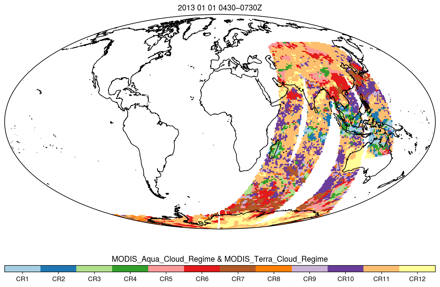
MODIS_CR_Equal_Area_3h
National Aeronautics and Space Administration —
The MODIS Collection 6.1 Equal-Area Three-Hourly Cloud Regime product. This product is a discrete classification of cloud fields at the mesoscale as observed by the... -
Federal
Gamma Ray Data: Peck (FIFE)
National Aeronautics and Space Administration —
Airborne soil moisture measurement is based on the difference between natural terrestrial gamma radiation flux measured for comparatively wet and dry soils. The... -
Federal
MODIS/Terra+Aqua Photosynthetically Active Radiation Daily/3-Hour L3 Global 5km SIN Grid V006
National Aeronautics and Space Administration —
MCD18A2 Version 6 was decommissioned on October 28, 2022. Users are encouraged to use the MCD18A2 Version 6.2 data product.The MCD18A2 Version 6 is a Moderate... -
Federal
GEO-CAPE : Geostationary Coastal and Air Pollution Events
National Aeronautics and Space Administration —
GEO-CAPE : Geostationary Coastal and Air Pollution Events -
Federal
VIIRS/NPP Thermal Anomalies/Fire 6-Min L2 Swath 750m V001
National Aeronautics and Space Administration —
The VNP14 VIIRS Version 1 data product was decommissioned on April 8th, 2025. Users are encouraged to use Version 2 data products, which provide better calibration... -
Federal
VIIRS/NPP Vegetation Indices 16-Day L3 Global 0.05Deg CMG V001
National Aeronautics and Space Administration —
The VNP13C1 VIIRS Version 1 data product was decommissioned on April 8th, 2025. Users are encouraged to use Version 2 data products, which provide better calibration... -
Federal
VIIRS/NPP Vegetation Indices 16-Day L3 Global 1km SIN Grid V001
National Aeronautics and Space Administration —
The VNP13A2 VIIRS Version 1 data product was decommissioned on April 8th, 2025. Users are encouraged to use Version 2 data products, which provide better calibration... -
Federal
GVHRR/ATS-6 Black and White Visible Images on Film V001 (GVHRRATS6IMVIS) at GES DISC
National Aeronautics and Space Administration —
GVHRRATS6IMVIS is the Geosynchronous Very High Resolution Radiometer (GVHRR) Black and White Visible Images on Film data product from the sixth Applications... -
Federal
HURRICANE AND SEVERE STORM SENTINEL (HS3) GLOBAL HAWK NAVIGATION V1
National Aeronautics and Space Administration —
The Hurricane and Severe Storm Sentinel (HS3) Global Hawk Navigation dataset consists of the real-time navigation and housekeeping data that was acquired from various... -
Federal
GRACE OCEAN BOTTOM GEOPOTENTIAL COEFFICIENTS JPL RELEASE 6.0 GAD
National Aeronautics and Space Administration —
FOR EXPERT USE ONLY. This dataset contains estimates of ocean bottom pressure derived from the Gravity Recovery and Climate Experiment (GRACE) mission measurements,... -
Federal
ARISE 2014 C-130 Remotely Sensed Aerosol and Trace Gas Data
National Aeronautics and Space Administration —
ARISE_Cloud_AircraftInSitu_C130_Data_1 is the Arctic Radiation - IceBridge Sea & Ice Experiment (ARISE) 2014 in-situ cloud data product. This product is a result...
24,675 datasets found for "q3텔Dbnaraㄱ_성인피시게임DB~⊇"