
-
Federal
NOAA-20 VIIRS Level-3 Global Mapped Triple-window Sea Surface Temperature (SST3) Data, version 2024.0 recent views
National Aeronautics and Space Administration —
The Visible and Infrared Imager/Radiometer Suite (VIIRS) is a multi-disciplinary instrument that is being flown on the Joint Polar Satellite System (JPSS) series of... -
Federal
NOAA-20 VIIRS Level-3 Global Mapped 11µm Nighttime Sea Surface Temperature (NSST) Data, version 2024.0 recent views
National Aeronautics and Space Administration —
The Visible and Infrared Imager/Radiometer Suite (VIIRS) is a multi-disciplinary instrument that is being flown on the Joint Polar Satellite System (JPSS) series of... -
Federal
SnowEx23 Mar23 IOP Community Snow Depth Measurements V001 recent views
National Aeronautics and Space Administration —
The data set contains snow depth measurements from five study sites in Alaska, USA; data were collected during the March 2023 intensive observation period (IOP) as... -
Federal
NOAA-20 VIIRS Level-3 Global Binned Triple-window Sea Surface Temperature (SST3) Data, version 2024.0 recent views
National Aeronautics and Space Administration —
The Visible and Infrared Imager/Radiometer Suite (VIIRS) is a multi-disciplinary instrument that is being flown on the Joint Polar Satellite System (JPSS) series of... -
Federal
NOAA-20 VIIRS Level-3 Global Binned Triple-window Sea Surface Temperature (SST3) - Near Real Time (NRT) Data, version 2024.0 recent views
National Aeronautics and Space Administration —
The Ocean Biology DAAC produces near real-time (quicklook) products using the best-available combination of ancillary data from meteorological and ozone data. As... -
Federal
NOAA-20 VIIRS Level-3 Global Binned 11µm Nighttime Sea Surface Temperature (NSST) Data, version 2024.0 recent views
National Aeronautics and Space Administration —
The Visible and Infrared Imager/Radiometer Suite (VIIRS) is a multi-disciplinary instrument that is being flown on the Joint Polar Satellite System (JPSS) series of... -
Federal
UC Berkeley CYGNSS Level 3 Daily RWAWC Watermask Version 3.2 recent views
National Aeronautics and Space Administration —
The CYGNSS Level 3 UC Berkeley Watermask Record Version 3.2 was developed by CYGNSS investigators in the Department of Civil and Environmental Engineering at the... -
Federal
High Mountain Asia 1 km MODIS-AIRS Gap-Filled Ground Temperatures and Permafrost Probability Maps, 2003-2016 V001 NGDA recent views
National Aeronautics and Space Administration —
This data set consists of 1 km resolution monthly land surface temperatures (MLSTs); mean annual ground temperatures (MAGTs); and estimates of permafrost extent (PE)... -
Federal
MEaSUREs ITS_LIVE Antarctic Annual 240 m Ice Sheet Extent Masks, 1997-2021 V001 recent views
National Aeronautics and Space Administration —
This ITS_LIVE data set, part of the Making Earth System Data Records for Use in Research Environments (MEaSUREs) Program, consists of 240 m Antarctic Ice Sheet extent... -
Federal
ATLAS/ICESat-2 L3B Monthly 3-Month Gridded Dynamic Ocean Topography V001 recent views
National Aeronautics and Space Administration —
This data set contains 3-month gridded averages of dynamic ocean topography (DOT) over midlatitude, north-polar, and south-polar grids derived from the along-track... -
Federal
ATLAS/ICESat-2 L3B Monthly Gridded Dynamic Ocean Topography V003 recent views
National Aeronautics and Space Administration —
This data set contains monthly gridded dynamic ocean topography (DOT), derived from along-track ATLAS/ICESat-2 L3A Ocean Surface Height product (ATL12). Monthly... -
Federal
ATLAS/ICESat-2 L3B Monthly Gridded Atmosphere V005 recent views
National Aeronautics and Space Administration —
This data set contains a gridded summary of monthly global cloud fraction, total column optical depth over the oceans, polar cloud fraction, blowing snow frequency,... -
Federal
ATLAS/ICESat-2 L3B Weekly Gridded Atmosphere V005 recent views
National Aeronautics and Space Administration —
This product reports weekly global cloud fraction, total column optical depth over the oceans, polar cloud fraction, blowing snow frequency, apparent surface... -
Federal
MODIS/Aqua Dark Target Aerosol 5-Min L2 Swath 10 km NGDA recent views
National Aeronautics and Space Administration —
The MODIS/Aqua Dark Target Aerosol 5-Min L2 Swath 10 km product, short-name XAERDT_L2_MODIS_Aqua is provided at 10-km spatial resolution (at-nadir) and a 5-minute... -
Federal
MODIS/Terra Dark Target Aerosol 5-Min L2 Swath 10 km NGDA recent views
National Aeronautics and Space Administration —
The MODIS/Terra Dark Target Aerosol 5-Min L2 Swath 10 km product, short-name XAERDT_L2_MODIS_Terra is provided at 10-km spatial resolution (at-nadir) and a 5-minute... -
Federal
VIIRS/SNPP Dark Target Aerosol L2 6-Min Swath 6km recent views
National Aeronautics and Space Administration —
The SNPP/VIIRS L2 Dark Target Aerosol 6-Min L2 Swath 6 km product, short-name XAERDT_L2_VIIRS_SNPP is provided at 6-km spatial resolution (at-nadir) and a 6-minute... -
Federal
SMAP Enhanced L1C Radiometer Half-Orbit 9 km EASE-Grid Brightness Temperatures V004 recent views
National Aeronautics and Space Administration —
This enhanced Level-1C (L1C) product contains calibrated and geolocated brightness temperatures acquired by the Soil Moisture Active Passive (SMAP) radiometer during... -
Federal
SMAP Enhanced L2 Radiometer Half-Orbit 9 km EASE-Grid Soil Moisture V006 recent views
National Aeronautics and Space Administration —
This enhanced Level-2 (L2) product contains calibrated, geolocated, brightness temperatures acquired by the Soil Moisture Active Passive (SMAP) radiometer during 6:00... -
Federal
CMS: Global 0.5-deg Wetland Methane Emissions and Uncertainty (WetCHARTs v1.3.3) recent views
National Aeronautics and Space Administration —
This dataset provides global monthly wetland methane (CH4) emissions estimates at 0.5 by 0.5-degree resolution for the period 2001-01-01 to 2022-08-31 that were... -
Federal
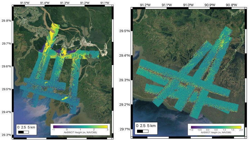
Delta-X: AirSWOT L2 Geocoded Water Surface Elevation, MRD, LA, 2021, V3 recent views
National Aeronautics and Space Administration —
This dataset contains Level 2 (L2) AirSWOT geocoded products, including estimated water surface elevation. The AirSWOT instrument is a Ka-band interferometer and for...

Official websites use .gov
A
.gov website belongs to an official government
organization in the United States.
Secure .gov websites use HTTPS
A
lock (
) or https:// means you’ve safely connected to
the .gov website. Share sensitive information only on official,
secure websites.