
-
Federal
China Dimensions Data Collection: GuoBiao (GB) Codes for the Administrative Divisions of the Peoples Republic of China
National Aeronautics and Space Administration —
The GuoBiao (GB) Codes for the Administrative Divisions of the People's Republic of China consists of geographic codes for the administrative divisions of China. The... -
Federal
Geocoded Disasters (GDIS) Dataset
National Aeronautics and Space Administration —
The Geocoded Disasters (GDIS) Dataset is a geocoded extension of a selection of natural disasters from the Centre for Research on the Epidemiology of Disasters'... -
Federal
UAVSAR_POLSAR_METADATA
National Aeronautics and Space Administration —
UAVSAR PolSAR Scene Metadata -
Federal
UAVSAR_POLSAR_INCIDENCE
National Aeronautics and Space Administration —
UAVSAR PolSAR Scene Incidence Angle -
Federal
UAVSAR_POLSAR_SLOPE
National Aeronautics and Space Administration —
UAVSAR PolSAR Scene Slope -
Federal
UAVSAR_POLSAR_ML_COMPLEX_GRD
National Aeronautics and Space Administration —
UAVSAR PolSAR Scene Projected -
Federal
Rock glaciers, Disko Island, Greenland, Version 1
National Aeronautics and Space Administration —
Disko Island (8600 km2) is situated west of central mainland Greenland. The island is part of the Tertiary volcanic province of West Greenland and is mainly made up... -
Federal
SAFARI 2000 Daily Rainfall Totals for Mongu, Zambia, 1999-2002
National Aeronautics and Space Administration —
This data set contains daily rainfall totals (mm) from Mongu, in the Western Province of Zambia. The data were collected with a British standard 5 inch diameter rain... -
Federal
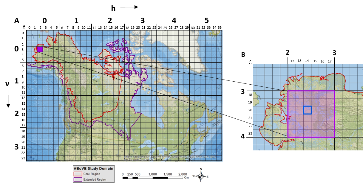
ABoVE: Study Domain and Standard Reference Grids, Version 2
National Aeronautics and Space Administration —
The Arctic - Boreal Vulnerability Experiment (ABoVE) has developed two standardized spatial data products to expedite coordination of research activities and to... -
Federal
BOREAS Regional Soils Data in Raster Format and AEAC Projection
National Aeronautics and Space Administration —
This data set was gridded by BORIS staff from a vector data set received from Canadian Soil Information System (CanSIS). The original data came in two parts that... -
Federal
BOREAS CanSIS Regional Soils Data in Vector Format, V2
National Aeronautics and Space Administration —
This data set contains soils data from the Canada Soil Information System (CanSIS) in ESRI Shapefile format for the provinces of Saskatchewan and Manitoba. They are... -
Federal
ABoVE: Study Domain and Standard Reference Grids
National Aeronautics and Space Administration —
The Arctic - Boreal Vulnerability Experiment (ABoVE) has developed two standardized spatial data products to expedite coordination of research activities and to... -
Federal
UAVSAR_POLSAR_ML_COMPLEX_GRD_5X5
National Aeronautics and Space Administration —
UAVSAR PolSAR Scene Projected Multilook 5x5 -
Federal
UAVSAR_POLSAR_ML_COMPLEX_GRD_3X3
National Aeronautics and Space Administration —
UAVSAR PolSAR Scene Projected Multilook 3x3 -
Federal
UAVSAR_POLSAR_ML_COMPLEX_SLANT
National Aeronautics and Space Administration —
UAVSAR PolSAR Scene Complex -
Federal
UAVSAR_POLSAR_DEM
National Aeronautics and Space Administration —
UAVSAR PolSAR Scene DEM TIFF -
Federal
UAVSAR_POLSAR_PAULI
National Aeronautics and Space Administration —
UAVSAR PolSAR Scene Pauli Decomposition -
Federal
Snowfall and Snow Depth for Canada 1943-1982, Version 1
National Aeronautics and Space Administration —
Data include monthly snowfall and end-of-month snow depth for 140 stations across Canada. Stations that maintained at least 20 years of data were chosen. The original...

Official websites use .gov
A
.gov website belongs to an official government
organization in the United States.
Secure .gov websites use HTTPS
A
lock (
) or https:// means you’ve safely connected to
the .gov website. Share sensitive information only on official,
secure websites.