
-
Federal
Global Maps of Atmospheric Nitrogen Deposition, 1860, 1993, and 2050 recent views
National Aeronautics and Space Administration —
This data set provides global gridded estimates of atmospheric deposition of total inorganic nitrogen (N), NHx (NH3 and NH4+), and NOy (all oxidized forms of nitrogen... -
Federal
Sounder SIPS: Suomi NPP CrIMSS Level 2 CLIMCAPS Normal Spectral Resolution: Atmosphere cloud and surface geophysical state V2 (SNDRSNIML2CCPRETN) at GES DISC recent views
National Aeronautics and Space Administration —
WARNING: To users of the derived product “co_mmr_midtrop” (carbon monoxide mass mixing ratio to dry air [kg/kg] at ~500 hPa). This variable has a significant bias due... -
Federal
Earth Radiation Budget Experiment (ERBE) S-4G Nonscanner, Wide Field of View (WFOV) Numerical Filter (NF) 5 degree Regional Averages recent views
National Aeronautics and Space Administration —
ERBE_S4G_WFOV_NF_1 is the Earth Radiation Budget Experiment (ERBE) S-4G Non-scanner, Wide Field of View (WFOV) Numerical Filter (NF) 5 degree Regional Averages data... -
Federal
GOES-R PLT Cloud Physics LiDAR (CPL) V1 recent views
National Aeronautics and Space Administration —
The GOES-R PLT Cloud Physics Lidar (CPL) dataset consists of backscatter coefficient, lidar depolarization ratio, layer top/base height, layer type, particulate... -
Federal
OMI/Aura NO2 Cloud-Screened Total and Tropospheric Column L3 Global Gridded 0.25 degree x 0.25 degree V3 (OMNO2d) at GES DISC recent views
National Aeronautics and Space Administration —
This is Level-3 daily global gridded (0.25x0.25 degree) Nitrogen Dioxide Product (OMNO2d). OMNO2d data product is a Level-3 Gridded Product where pixel level data of... -
Federal
MISR Level 3 Global Joint Aerosol monthly product V002 recent views
National Aeronautics and Space Administration —
MIL3MJTA_2 is the Multi-angle Imaging SpectroRadiometer (MISR) Level 3 Global Joint Aerosol monthly product version 2 data product. It contains global statistical... -
Federal
GEOS-5 FP-IT 3D Time-Averaged Model-Layer Assimilated Data Geo-Colocated to OMI/Aura UV2 1-Orbit L2 Swath 13x24km V4 (OMUFPMET) at GES DISC recent views
National Aeronautics and Space Administration —
The GEOS-5 FP-IT 3D Time-Averaged Model-Layer Assimilated Data Geo-Colocated to OMI/Aura UV2 1-Orbit L2 Swath 13x24km (OMUFPMET) product provides selected... -
Federal
CERES Monthly Gridded Radiative Fluxes and Clouds Terra FM1 Edition2F recent views
National Aeronautics and Space Administration —
CER_FSW_Terra-FM1-MODIS_Edition2F is the Clouds and the Earth's Radiant Energy System (CERES) Monthly Gridded Radiative Fluxes and Clouds Terra Flight Model 1 (FM1)... -
Federal
MISR Level 3 Component Global Aerosol Product covering a month V004 recent views
National Aeronautics and Space Administration —
MIL3MAE_4 is the Multi-angle Imaging SpectroRadiometer (MISR) Level 3 Component Global Aerosol Product covering a month version 4. It contains a statistical summary... -
Federal
CERES Clouds and Radiative Swath Terra FM1 MODIS Edition2B recent views
National Aeronautics and Space Administration —
CER_CRS_Terra-FM1-MODIS_Edition2B is the Clouds and the Earth's Radiant Energy System (CERES) Clouds and Radiative Swath (CRS) Terra Flight Model 1 (FM1) Moderate-... -
Federal
NLDAS Secondary Forcing Data L4 Hourly 0.125 x 0.125 degree V2.0 (NLDAS_FORB0125_H) at GES DISC recent views
National Aeronautics and Space Administration —
This data set contains the secondary forcing hourly data "File B" for Phase 2 of the North American Land Data Assimilation System (NLDAS-2). The data are in 1/8th... -
Federal
MODIS/Terra Clouds 5-Min L2 Swath 1km and 5km NGDA recent views
National Aeronautics and Space Administration —
The MODIS/Terra Clouds 5-Min L2 Swath 1km and 5km product (MOD06_L2) consists of cloud optical and physical parameters. These parameters are derived using remotely... -
Federal
OMPS-NPP L3 NM Ozone (O3) Total Column 1.0 deg grid daily V2 recent views
National Aeronautics and Space Administration —
The OMPS-NPP L3 NM Ozone (O3) Total Column 1.0 deg grid daily product provides total ozone measurements from the Ozone Mapping and Profiling Suite (OMPS) Nadir-Mapper... -
Federal
GLDAS Catchment Land Surface Model L4 daily 0.25 x 0.25 degree GRACE-DA1 V2.2 (GLDAS_CLSM025_DA1_D) at GES DISC recent views
National Aeronautics and Space Administration —
NASA Global Land Data Assimilation System Version 2 (GLDAS-2) has three components: GLDAS-2.0, GLDAS-2.1, and GLDAS-2.2. GLDAS-2.0 is forced entirely with the... -
Federal
Quality Controlled Lightning Imaging Sensor (LIS) on International Space Station (ISS) Backgrounds V2 recent views
National Aeronautics and Space Administration —
The Quality Controlled Lightning Imaging Sensor (LIS) on International Space Station (ISS) Backgrounds dataset was collected by the LIS instrument mounted on the ISS... -
Federal
TRMM (TMPA-RT) Near Real-Time Precipitation L3 3 hour 0.25 degree x 0.25 degree V7 (TRMM_3B42RT) at GES DISC recent views
National Aeronautics and Space Administration —
TMPA (3B42RT) dataset have been discontinued as of Dec. 31, 2019, and users are strongly encouraged to shift to the successor IMERG datasets (doi:... -
Federal
OMI/Aura Ozone (O3) Total Column Daily L2 Global Gridded 0.25 degree x 0.25 degree V3 (OMTO3G) at GES DISC recent views
National Aeronautics and Space Administration —
This Level-2G daily global gridded product OMTO3G is based on the pixel level OMI Level-2 Total Ozone Product OMTO3. The OMTO3 product is from the enhanced TOMS... -
Federal
CERES A-Train Integrated CALIPSO, CloudSat, CERES, and MODIS (CCCM) Merged Release B1 NGDA recent views
National Aeronautics and Space Administration —
CER-NEWS_CCCM_Aqua-FM3-MODIS-CAL-CS_RelB1 is the Clouds and the Earth's Radiant Energy System (CERES) NASA Energy and Water cycle Study (NEWS) A-Train Integrated... -
Federal
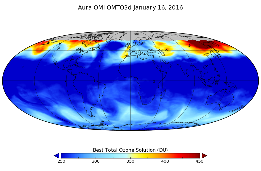
OMI/Aura TOMS-Like Ozone, Aerosol Index, Cloud Radiance Fraction L3 1 day 1 degree x 1 degree V3 (OMTO3d) at GES DISC recent views
National Aeronautics and Space Administration —
The OMI science team produces this Level-3 daily global TOMS-Like Total Column Ozone gridded product OMTO3d (1 deg Lat/Lon grids). The OMTO3d product is produced by... -
Federal
CALIPSO Lidar Level 3 Tropospheric Aerosol Profiles, Cloud Free Data, Standard V4-20 recent views
National Aeronautics and Space Administration —
CAL_LID_L3_Tropospheric_APro_CloudFree-Standard-V4-20 is the Cloud-Aerosol Lidar and Infrared Pathfinder Satellite Observation (CALIPSO) Lidar Level 3 Tropospheric...

Official websites use .gov
A
.gov website belongs to an official government
organization in the United States.
Secure .gov websites use HTTPS
A
lock (
) or https:// means you’ve safely connected to
the .gov website. Share sensitive information only on official,
secure websites.