
-
Federal
NACP North American Forest Dynamics Project: Forest Disturbance and Regrowth Data 18 recent views
National Aeronautics and Space Administration —
This data set provides the results of time-series analyses of Landsat imagery for 55 selected forested sites across the conterminous U.S.A. The output is a pair of... -
Federal
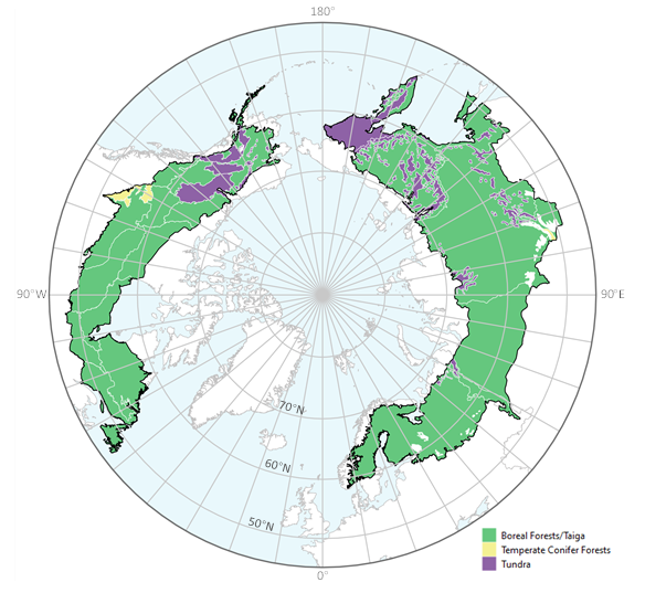
ABoVE: Tree Canopy Cover and Stand Age from Landsat, Boreal Forest Biome, 1984-2020
National Aeronautics and Space Administration —
This dataset contains Landsat-derived locally-calibrated estimates of tree canopy cover (TCC) and forest stand age across global boreal forests from 1984-2020 in... -
Federal
Last of the Wild Project, Version 3 (LWP-3): 2009 Human Footprint, 2018 Release
National Aeronautics and Space Administration —
The 2009 Human Footprint, 2018 Release provides a global map of the cumulative human pressure on the environment in 2009, at a spatial resolution of ~1 km. The human... -
Federal
Merged Sentinel-3A and Sentinel-3B OLCI Global Binned Cyanobacteria Index (CI) Data, version 5.0
National Aeronautics and Space Administration —
Cyanobacteria Assessment Network (CyAN) is a multi-agency project among EPA, the National Aeronautics and Space Administration (NASA), the National Oceanic and... -
Federal
NOAA-20 VIIRS Global Binned Inherent Optical Properties (IOP) Data, version R2022.0
National Aeronautics and Space Administration —
The Visible and Infrared Imager/Radiometer Suite (VIIRS) is a multi-disciplinary instrument that is being flown on the Joint Polar Satellite System (JPSS) series of... -
Federal
NOAA-20 VIIRS Regional Inherent Optical Properties (IOP) Data, version R2022.0
National Aeronautics and Space Administration —
The Visible and Infrared Imager/Radiometer Suite (VIIRS) is a multi-disciplinary instrument that is being flown on the Joint Polar Satellite System (JPSS) series of... -
Federal
OrbView-2 SeaWiFS Global Binned Inherent Optical Properties (IOP) Data, version R2022.0
National Aeronautics and Space Administration —
The SeaWiFS instrument was launched by Orbital Sciences Corporation on the OrbView-2 (a.k.a. SeaStar) satellite in August 1997, and collected data from September 1997... -
Federal
GEDI L4A Footprint Level Aboveground Biomass Density, Version 2.1
National Aeronautics and Space Administration —
This dataset contains Global Ecosystem Dynamics Investigation (GEDI) Level 4A (L4A) Version 2 predictions of the aboveground biomass density (AGBD; in Mg/ha) and... -
Federal
Global Man-made Impervious Surface (GMIS) Dataset From Landsat
National Aeronautics and Space Administration —
The Global Man-made Impervious Surface (GMIS) Dataset From Landsat consists of global estimates of fractional impervious cover derived from the Global Land Survey... -
Federal
NACP Site: Terrestrial Biosphere Model Output Data in Original Format
National Aeronautics and Space Administration —
This data set contains the original model output data submissions from the 24 terrestrial biosphere models (TBM) that participated in the North American Carbon... -
Federal
Spectral Reflectance and Ancillary Data, Tundra Transect, North Slope, AK, 2000-2022
National Aeronautics and Space Administration —
This dataset provides visible-near infrared spectral reflectance, descriptions of vegetation cover, surface temperature, the total fraction of absorbed... -
Federal
PalEON: Terrestrial Ecosystem Model Drivers for the Northeastern U.S., 0850-2010
National Aeronautics and Space Administration —
This dataset from the PalEON Ecosystem Model Intercomparison Project (PEMIP) provides harmonized regional environmental and meteorological drivers at a resolution of... -
Federal
Aqua MODIS Regional Inherent Optical Properties (IOP) Data, version R2022.0 NGDA
National Aeronautics and Space Administration —
MODIS (or Moderate-Resolution Imaging Spectroradiometer) is a key instrument aboard the Terra (EOS AM) and Aqua (EOS PM) satellites. Terra's orbit around the Earth is... -
Federal
ABoVE: Photochemical Reflectance and Tree Growth, Brooks Range, Alaska, 2018-2019
National Aeronautics and Space Administration —
This dataset provides simultaneous in-situ measurements of the photochemical reflectance index (PRI) and radial tree growth of selected white spruce trees (Picea... -
Federal
Delta-X: Real-Time Kinematic Elevation Measurements for Coastal Wetlands, LA, 2021
National Aeronautics and Space Administration —
This dataset provides real-time kinematic (RTK) GPS elevation measurements, along with horizontal and vertical precision errors, obtained along transects near... -
Federal
Sentinel-3A OLCI Global Mapped CyAN Project, True Color (TC) - Near Real-Time (NRT) Data, version 5.0
National Aeronautics and Space Administration —
The Ocean Biology DAAC produces near real-time (quicklook) products using the best-available combination of ancillary data from meteorological and ozone data. As... -
Federal
Sentinel-3B OLCI Global Mapped CyAN Project, True Color (TC) - Near Real-Time (NRT) Data, version 5.0
National Aeronautics and Space Administration —
The Ocean Biology DAAC produces near real-time (quicklook) products using the best-available combination of ancillary data from meteorological and ozone data. As... -
Federal
ABoVE: Distribution Maps of Wildland Fire Fuel Components across Alaskan Tundra, 2015
National Aeronautics and Space Administration —
This dataset provides maps of the distribution of three major wildland fire fuel types at 30 m spatial resolution covering the Alaskan arctic tundra, circa 2015. The... -
Federal
NOAA-20 VIIRS Global Mapped Inherent Optical Properties (IOP) - Near Real-time (NRT) Data, version R2022.0
National Aeronautics and Space Administration —
The Ocean Biology DAAC produces near real-time (quicklook) products using the best-available combination of ancillary data from meteorological and ozone data. As... -
Federal
Suomi-NPP VIIRS Global Mapped Inherent Optical Properties (IOP) - Near Real-time (NRT) Data, version R2022.0
National Aeronautics and Space Administration —
The Ocean Biology DAAC produces near real-time (quicklook) products using the best-available combination of ancillary data from meteorological and ozone data. As...

Official websites use .gov
A
.gov website belongs to an official government
organization in the United States.
Secure .gov websites use HTTPS
A
lock (
) or https:// means you’ve safely connected to
the .gov website. Share sensitive information only on official,
secure websites.