
-
Federal
Landsat 8 recent views
National Aeronautics and Space Administration —
The Operational Land Imager (OLI) and Thermal Infrared Sensor (TIRS) are onboard the Landsat 8 satellite, have acquired images of the Earth since February 2013. The... -
Federal
Global Land Cover Characterization Program recent views
National Aeronautics and Space Administration —
The Global Land Cover Characterization Project was established to meet science data requirements identified by the International Geosphere and Biosphere Programme... -
Federal
SMEX04 Airborne Visible/Infrared Imaging Spectrometer (AVIRIS) Data: Arizona, Version 1 recent views
National Aeronautics and Space Administration —
Notice to Data Users: The documentation for this data set was provided solely by the Principal Investigator(s) and was not further developed, thoroughly reviewed, or... -
Federal
North American Landscape Characterization recent views
National Aeronautics and Space Administration —
The North American Landscape Characterization (NALC) project is a component of the Landsat Pathfinder Program, which is part of a larger Pathfinder Program initiated... -
Federal
SHIFT: AVIRIS-NG Full-Resolution True Color Images recent views
National Aeronautics and Space Administration —
This dataset holds full-resolution 3-band (true color) imagery acquired by NASA's Airborne Visible / Infrared Imaging Spectrometer-Next Generation (AVIRIS-NG)... -
Federal
USGS Digital Orthophoto Quadrangles recent views
National Aeronautics and Space Administration —
A Digital Orthophoto Quadrangle (DOQ) is a computer-generated image of an aerial photograph in which the image displacement caused by terrain relief and camera tilt... -
Federal
AVHRR 1-km Global Land 10-Day Composites recent views
National Aeronautics and Space Administration —
The Advanced Very High Resolution Radiometer (AVHRR) 1-km Global Land 10-Day Composites data set project is a component of the National Aeronautics and Space... -
Federal
Aerial Photographs (from AMES Pilot Land Data System); USGS EDC, Sioux Falls recent views
National Aeronautics and Space Administration —
The aerial photography inventoried by the Pilot Land Data System (PLDS) at NASA AMES Research Center has been transferred to the USGS EROS Data Center. The photos... -
Federal
NASA Landsat Data Collection recent views
National Aeronautics and Space Administration —
The NASA Landsat Data Collection (NLDC) is a compilation of Landsat multispectral scanner (MSS) scenes and Landsat thematic mapper (TM) scenes. This compilation of... -
Federal
MASTER: HyspIRI Airborne Campaign, California, Spring 2015 recent views
National Aeronautics and Space Administration —
This dataset includes Level 1B (L1B) and Level 2 (L2) data products from the MODIS/ASTER Airborne Simulator (MASTER) instrument. The spectral data were collected as... -
Federal
ABoVE: Lake Growing Season Green Surface Reflectance Trends, AK and Canada, 1984-2019 recent views
National Aeronautics and Space Administration —
This dataset provides an annual time series of Landsat green surface reflectance and the derived annual trend during the growing season (June and July) for 472,890... -
Federal
GPM Ground Validation Airborne Snow Observatory (ASO) OLYMPEX V1 recent views
National Aeronautics and Space Administration —
The GPM Ground Validation Airborne Snow Observatory (ASO) OLYMPEX dataset consists of snow depth, bare earth surface, land surface classification and a Red, Green,... -
Federal
ASTER Registered Radiance at the Sensor - Orthorectified V003 NGDA recent views
National Aeronautics and Space Administration —
The ASTER Orthorectified Registered Radiance at the Sensor (AST14OTH) product (https://lpdaac.usgs.gov/documents/618/ASTER_Earthdata_Search_Order_Instructions.pdf)... -
Federal
EO-1 Hyperion recent views
National Aeronautics and Space Administration —
The Earth-Observing One (EO-1) satellite was decommissioned March 2017. The EO-1 satellite was launched on November 21, 2000 with the NASA's New Millennium Program... -
Federal
ASTER Orthorectified Digital Elevation Model (DEM) V003 NGDA recent views
National Aeronautics and Space Administration —
The ASTER Digital Elevation Model and Orthorectified Registered Radiance at the Sensor (AST14DMO) product... -
Federal
CLPX-Satellite: MODIS Radiances, Reflectances, Snow Cover and Related Grids, Version 1 NGDA recent views
National Aeronautics and Space Administration —
This data set provides Moderate Resolution Imaging Spectroradiometer (MODIS) data as part of the Cold Land Processes Field Experiment (CLPX). Parameters include... -
Federal
MASTER: Airborne Science, Western US, April, 2004 recent views
National Aeronautics and Space Administration —
This dataset includes Level 1B (L1B) and Level 2 (L2) data products from the MODIS/ASTER Airborne Simulator (MASTER) instrument. The spectral data were collected... -
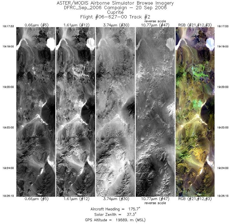
Federal
MASTER: Airborne Science, Western US, September, 2006 recent views
National Aeronautics and Space Administration —
This dataset includes Level 1B (L1B) and Level 2 (L2) data products from the MODIS/ASTER Airborne Simulator (MASTER) instrument. The spectral data were collected... -
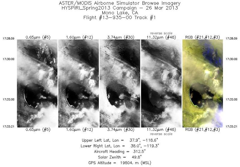
Federal
MASTER: HyspIRI Airborne Campaign, California, Early Spring 2013, V2 recent views
National Aeronautics and Space Administration —
This dataset includes Level 1B (L1B) and Level 2 (L2) data products from the MODIS/ASTER Airborne Simulator (MASTER) instrument. The spectral data were collected as... -
Federal
MASTER: BP Oil Spill Mapping, Louisiana-Gulf of Mexico-Wisconsin, Fall, 2010 recent views
National Aeronautics and Space Administration —
This dataset includes Level 1B (L1B) and Level 2 (L2) data products from the MODIS/ASTER Airborne Simulator (MASTER) instrument. The raw data were collected during 9...

Official websites use .gov
A
.gov website belongs to an official government
organization in the United States.
Secure .gov websites use HTTPS
A
lock (
) or https:// means you’ve safely connected to
the .gov website. Share sensitive information only on official,
secure websites.