
-
Federal
ABoVE: Synthesis of Burned and Unburned Forest Site Data, AK and Canada, 1983-2016 recent views
National Aeronautics and Space Administration —
This dataset is a synthesis of field plot characterization data, derived above-ground and below-ground combusted carbon, and acquired Fire Weather Index (FWI) System... -
Federal
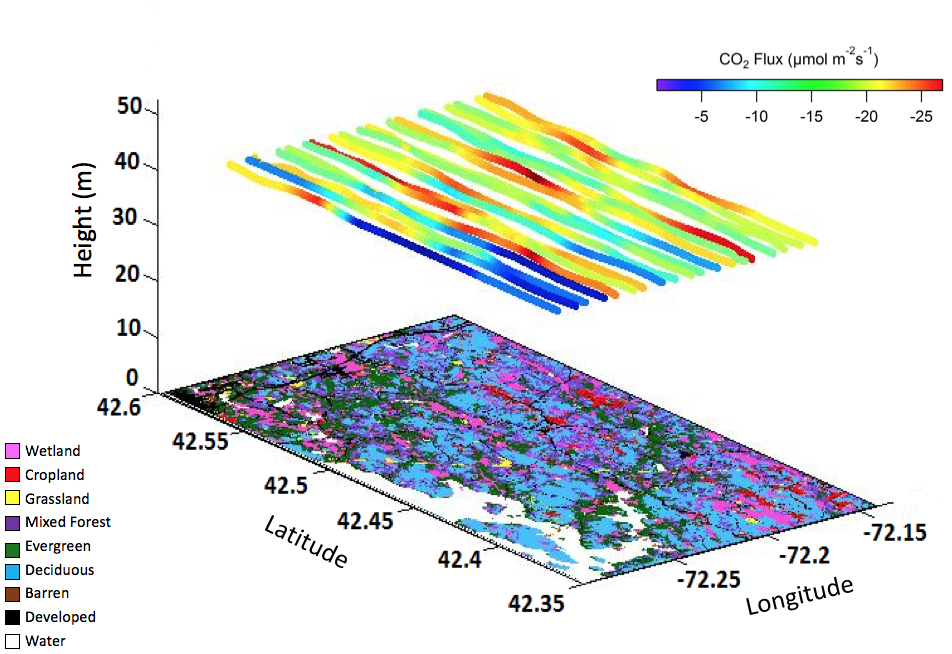
AirMOSS: L2 Airborne Carbon Flux at Selected AirMOSS Sites, 2012-2014 recent views
National Aeronautics and Space Administration —
This data set contains carbon flux measurements recorded by an aircraft at the Duke, Harvard, and Howland Forest sites during the summers of 2012-2014 as part of the... -
Federal
ABoVE: Rain-on-Snow Frequency and Distribution during Cold Seasons, Alaska, 2003-2016 NGDA recent views
National Aeronautics and Space Administration —
This dataset provides maps of rain-on-snow (ROS) events across Alaska for the individual months of November to March 2002-2011 and November to March 2012-2016, and... -
Federal
ACT-America: L1 Raw, Uncalibrated In-Situ CO2, CO, and CH4 Mole Fractions from Towers recent views
National Aeronautics and Space Administration —
This dataset provides Level 1 (L1) in situ atmospheric carbon dioxide (CO2), carbon monoxide (CO), and methane (CH4) concentrations as measured on a network of... -
Federal
CARVE: Ecosystem Scale CH4 Emission Derived from Aircraft Observations 2012-2014 recent views
National Aeronautics and Space Administration —
This dataset provides methane flux estimates derived from airborne measurements collected over Alaska and the western Yukon Territory during the Carbon in Arctic... -
Federal
CARVE: CH4, CO2, and CO Atmospheric Concentrations, CARVE Tower, Alaska, 2012-2014 recent views
National Aeronautics and Space Administration —
This data set provides hourly atmospheric concentrations of methane (CH4), carbon dioxide (CO2), and carbon monoxide (CO) as mole fractions, from January 2012 to... -
Federal
ABoVE: Directory of Field Sites Associated with 2017 ABoVE Airborne Campaign recent views
National Aeronautics and Space Administration —
This dataset provides a listing of the ~6,700 field sites used in planning the ABoVE Airborne Campaign (AAC) for 2017. The sites included point, polygon, and line... -
Federal
AirMOSS: L2 Hourly Precipitation at AirMOSS Sites, 2011-2015 recent views
National Aeronautics and Space Administration —
This data set provides level 2 (L2) calibrated hourly precipitation (cm/hr) from rain gauges at seven North American sites as part of the Airborne Microwave... -
Federal
LBA-ECO TG-03 Aeronet Aerosol Optical Thickness Measurements, Brazil: 1993-2005 recent views
National Aeronautics and Space Administration —
This data set includes aerosol optical thickness measurements from the CIMEL sunphotometer for 22 sites in Brazil during the period from 1993-2005. The AERONET... -
Federal
Pre-Delta-X: Spectral Reflectance of Water Surface, Atchafalaya Basin, LA, USA, 2016 recent views
National Aeronautics and Space Administration —
This dataset provides measurements of in situ remote-sensing reflectance (Rrs; per steradian) of surface water across Atchafalaya Basin, southern coastal Louisiana,... -
Federal
NACP Greenhouse Gases Multi-Source Data Compilation, 2000-2009 recent views
National Aeronautics and Space Administration —
This data set is a collection of measurements of carbon dioxide (CO2) and non-CO2 greenhouse gases made across North America by nine independent atmospheric... -
Federal
ABoVE: Burned Area, Depth, and Combustion for Alaska and Canada, 2001-2019 NGDA recent views
National Aeronautics and Space Administration —
This dataset provides annual gridded estimates of fire locations and associated burn fraction per pixel for Alaska and Canada at approximately 500 m spatial... -
Federal
BOREAS AFM-01 NOAA/ATDD Long-EZ Aircraft Flux Data over the SSA recent views
National Aeronautics and Space Administration —
Data include aircraft altitude, wind direction, wind speed, air temperature, potential temperature, water mixing ratio, U and V components of wind velocity, static... -
Federal
SAFARI 2000 Daily Rainfall Estimates, 0.1-Deg, Southern Africa, 1993-2001 recent views
National Aeronautics and Space Administration —
The Microwave InfraRed Algorithm (MIRA) is used to produce an imagery data set of daily mean rain rates at 0.1 degree spatial resolution over southern Africa for the... -
Federal
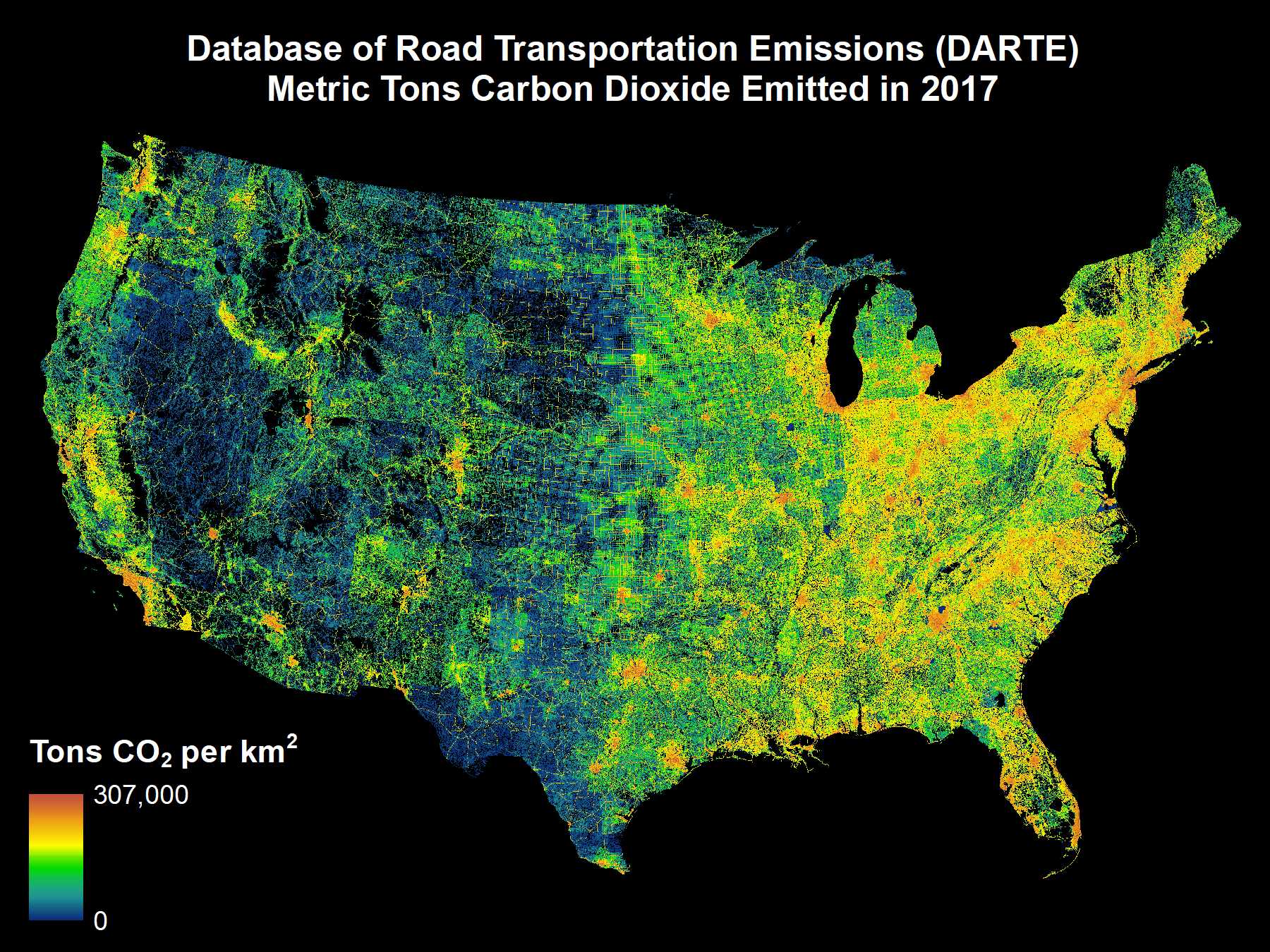
DARTE Annual On-road CO2 Emissions on a 1-km Grid, Conterminous USA, V2, 1980-2017 recent views
National Aeronautics and Space Administration —
This data set provides a 38-year, 1-km resolution inventory of annual on-road CO2 emissions for the conterminous United States based on roadway-level vehicle traffic... -
Federal
ISLSCP II Ecosystem Rooting Depths NGDA recent views
National Aeronautics and Space Administration —
The goal of this study was to predict the global distribution of plant rooting depths based on data about global aboveground vegetation structure and climate.... -
Federal
NWS Daily Climatology Data: 1975 (SNF) recent views
National Aeronautics and Space Administration —
Daily min, max, average temperature (F), precipitation (water equivalent in inches), and daily insolation (Langleys) for the Superior National Forest area as... -
Federal
Bowen Ratio Surface Flux: Smith (FIFE) recent views
National Aeronautics and Space Administration —
Retrieval of surface fluxes from a combination of satellite & surface platforms -
Federal
Vulcan: High-Resolution Hourly Fossil Fuel CO2 Emissions in USA, 2010-2015, Version 3 recent views
National Aeronautics and Space Administration —
The Vulcan version 3.0 hourly dataset quantifies hourly emissions at a 1-km resolution for the 2010-2015 time period. Estimates are provided of hourly carbon dioxide... -
Federal
Geoecology: County-Level Environmental Data for the United States, 1941-1981 recent views
National Aeronautics and Space Administration —
The Geoecology database is a compilation of environmental data for the period 1941 to 1981. The Geoecology database contains selected data on terrain and soils, water...

Official websites use .gov
A
.gov website belongs to an official government
organization in the United States.
Secure .gov websites use HTTPS
A
lock (
) or https:// means you’ve safely connected to
the .gov website. Share sensitive information only on official,
secure websites.