
-
Federal
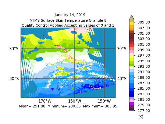
Sounder SIPS: JPSS-1 ATMS Level 2 RAMSES2 Support V3 (SNDRJ1ML2RMSSUP) at GES DISC
National Aeronautics and Space Administration —
This level 2 support product is generated by the RAMSES (Retrieval Algorithm for Microwave Sounders in Earth Science) II algorithm.The RAMSES II algorithm is a... -
Federal
VIIRS/NPP BRDF/Albedo Model Parameters Daily L3 Global 1km SIN Grid V001
National Aeronautics and Space Administration —
The NASA/NOAA Suomi National Polar-orbiting Partnership (Suomi NPP) Visible Infrared Imaging Radiometer Suite (VIIRS) Bidirectional Reflectance Distribution Function... -
Federal
MODIS/Terra NDVI Phenology annual L4 250m SIN Grid NGDA
National Aeronautics and Space Administration —
The MODIS/Terra NDVI Phenology annual L4 250m SIN Grid product, with short-name MOD09Q1P_NDVI is a Gap-filled Smoothed NDVI created from the MOD09A1 8-day Surface... -
Federal
Sounder SIPS: Suomi NPP CrIMSS Level 3 Specific Quality Control Gridded Monthly SiFSAP V2 (SNDRSNIML3SMSFSP) at GES DISC
National Aeronautics and Space Administration —
The SIFSAP (Single Field-of-View Sounder Atmospheric Products) algorithm provides retrieval for each sounder Field of View (FOV), therefore, it has 3-times higher... -
Federal
Sounder SIPS: Suomi NPP CrIMSS Level 3 Comprehensive Quality Control Gridded Monthly CHART Normal Spectral Resolution V1
National Aeronautics and Space Administration —
The objective of this limited edition data collection is to examine products generated by the Climate Heritage AIRS Retrieval Technique (CHART) algorithm to analyze... -
Federal
Sounder SIPS: Suomi NPP CrIMSS Level 3 Comprehensive Quality Control Gridded Daily CLIMCAPS Full Spectral Resolution V2 at GES DISC
National Aeronautics and Space Administration —
WARNING: To users of the derived product “co_mmr_midtrop” (carbon monoxide mass mixing ratio to dry air [kg/kg] at ~500 hPa). This variable has a significant bias due... -
Federal
Reduced Resolution Geophysical Product for Ocean, Land and Atmosphere
National Aeronautics and Space Administration —
The Medium Resolution Imaging Spectrometer (MERIS) is one of 10 sensors deployed in March of 2002 on board the polar-orbiting Envisat-1 environmental research... -
Federal
Reduced Resolution Geolocated and Calibrated TOA Radiance
National Aeronautics and Space Administration —
The Medium Resolution Imaging Spectrometer (MERIS) is one of 10 sensors deployed in March of 2002 on board the polar-orbiting Envisat-1 environmental research... -
Federal
NOAA-14 AVHRR Atmospherically Corrected Surface Reflectance Daily L3 Global 0.05 Deg. CMG
National Aeronautics and Space Administration —
The Long-Term Data Record (LTDR) produces, validates, and distributes a global land surface climate data record (CDR) that uses both mature and well-tested algorithms... -
Federal
NOAA-07 AVHRR Top-of-Atmosphere Reflectance Daily L3 Global 0.05 Deg. CMG
National Aeronautics and Space Administration —
The Long-Term Data Record (LTDR) produces, validates, and distributes a global land surface climate data record (CDR) that uses both mature and well-tested algorithms... -
Federal
NRT AMSR2 Unified L2B Half-Orbit 25 km EASE-Grid Surface Soil Moisture Beta V2
National Aeronautics and Space Administration —
The Advanced Microwave Scanning Radiometer 2 (AMSR2) instrument on the Global Change Observation Mission - Water 1 (GCOM-W1) provides global passive microwave... -
Federal
NOAA-09 AVHRR Atmospherically Corrected Normalized Difference Vegetation Index Daily L3 Global 0.05 Deg. CMG
National Aeronautics and Space Administration —
The Long-Term Data Record (LTDR) produces, validates, and distributes a global land surface climate data record (CDR) that uses both mature and well-tested algorithms... -
Federal
NOAA-11 AVHRR Top-of-Atmosphere Reflectance Daily L3 Global 0.05 Deg. CMG
National Aeronautics and Space Administration —
The Long-Term Data Record (LTDR) produces, validates, and distributes a global land surface climate data record (CDR) that uses both mature and well-tested algorithms... -
Federal
NOAA-16 AVHRR Atmospherically Corrected Surface Reflectance Daily L3 Global 0.05 Deg. CMG
National Aeronautics and Space Administration —
The Long-Term Data Record (LTDR) produces, validates, and distributes a global land surface climate data record (CDR) that uses both mature and well-tested algorithms... -
Federal
NOAA-18 AVHRR Top-of-Atmosphere Reflectance Daily L3 Global 0.05 Deg. CMG
National Aeronautics and Space Administration —
The Long-Term Data Record (LTDR) produces, validates, and distributes a global land surface climate data record (CDR) that uses both mature and well-tested algorithms... -
Federal
NOAA-19 AVHRR Top-of-Atmosphere Reflectance Daily L3 Global 0.05 Deg. CMG
National Aeronautics and Space Administration —
The Long-Term Data Record (LTDR) produces, validates, and distributes a global land surface climate data record (CDR) that uses both mature and well-tested algorithms... -
Federal
NOAA-16 AVHRR Atmospherically Corrected Normalized Difference Vegetation Index Daily L3 Global 0.05 Deg. CMG
National Aeronautics and Space Administration —
The Long-Term Data Record (LTDR) produces, validates, and distributes a global land surface climate data record (CDR) that uses both mature and well-tested algorithms... -
Federal
NOAA-14 AVHRR Atmospherically Corrected Normalized Difference Vegetation Index Daily L3 Global 0.05 Deg. CMG
National Aeronautics and Space Administration —
The Long-Term Data Record (LTDR) produces, validates, and distributes a global land surface climate data record (CDR) that uses both mature and well-tested algorithms... -
Federal
NOAA-09 AVHRR Top-of-Atmosphere Reflectance Daily L3 Global 0.05 Deg. CMG
National Aeronautics and Space Administration —
The Long-Term Data Record (LTDR) produces, validates, and distributes a global land surface climate data record (CDR) that uses both mature and well-tested algorithms... -
Federal
NOAA19 AVHRR Atmospherically Corrected Normalized Difference Vegetation Index Daily L3 Global 0.05 Deg. CMG
National Aeronautics and Space Administration —
The Long-Term Data Record (LTDR) produces, validates, and distributes a global land surface climate data record (CDR) that uses both mature and well-tested algorithms...

Official websites use .gov
A
.gov website belongs to an official government
organization in the United States.
Secure .gov websites use HTTPS
A
lock (
) or https:// means you’ve safely connected to
the .gov website. Share sensitive information only on official,
secure websites.