
-
Federal
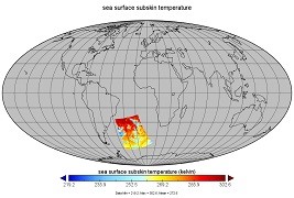
Aquarius Official Release Level 3 Ancillary Reynolds Sea Surface Temperature Standard Mapped Image Descending 7-Day Data V5.0
National Aeronautics and Space Administration —
Aquarius Level 3 ancillary sea surface temperature (SST) standard mapped image data are the ancillary SST data used in the Aquarius calibration for salinity... -
Federal
Aerosol Characterization Experiment (ACE) - Asia
National Aeronautics and Space Administration —
Measurements taken during the Aerosol Characterization Experiment (ACE) off the coast of Asia in the East China Sea, Sea of Japan, and Pacific Ocean. -
Federal
GHRSST NOAA/STAR GOES-17 ABI L3C America Region SST v2.71 dataset in GDS2
National Aeronautics and Space Administration —
The ACSPO G17/ABI L3C (Level 3 Collated) product is a gridded version of the ACSPO G17/ABI L2P product available at... -
Federal
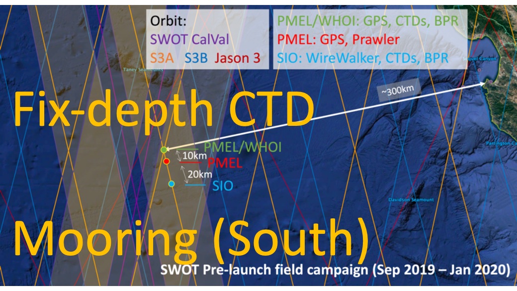
SWOT 2019-2020 Prelaunch Oceanography Field Campaign SIO Moored Fixed-Depth CTDs
National Aeronautics and Space Administration —
This dataset provides the conductivity, temperature and depth (CTD) measurements from the fixed-depth CTD sensors mounted on a full-depth mooring deployed by the SWOT... -
Federal
GHRSST Level 2P NOAA STAR SST v2.80 from VIIRS on S-NPP Satellite
National Aeronautics and Space Administration —
The Joint Polar Satellite System (JPSS), starting with S-NPP launched on 28 October 2011, is the new generation of the US Polar Operational Environmental Satellites... -
Federal
Tokyo Bay measurements from 1982-1984
National Aeronautics and Space Administration —
Measurements taken in the Tokyo Bay between 1982 and 1984. -
Federal
Geochemistry, Phytoplankton, and Color of the Ocean (GePCO) program
National Aeronautics and Space Administration —
Measurements taken during 2001 under the Geochemistry, Phytoplankton, and Color of the Ocean (GePCO) program. -
Federal
Measurements made by the NOAA R/V Ron H. Brown
National Aeronautics and Space Administration —
Measurements made by the NOAA research vessel, the Ron H. Brown between 2000 and 2002. -
Federal
AIRS/Aqua L3 8-day Standard Physical Retrieval (AIRS+AMSU+HSB) 1 degree x 1 degree V006 (AIRH3ST8) at GES DISC
National Aeronautics and Space Administration —
The Atmospheric Infrared Sounder (AIRS) is a grating spectrometer (R = 1200) aboard the second Earth Observing System (EOS) polar-orbiting platform, EOS Aqua. In... -
Federal
Trichonesia cruise
National Aeronautics and Space Administration —
Measurements from Indonesia made during 1998. -
Federal
Observations from the Western Gulf of Maine
National Aeronautics and Space Administration —
Observations from the Western Gulf of Maine -
Federal
Turkish Seas pigment measurements
National Aeronautics and Space Administration —
Chlorophyll-a and pigment measurements made in the seas surrounding Turkey between 1997 and 1999. -
Federal
Monsoonal Arabian Sea measurements to validate OceanSat-2
National Aeronautics and Space Administration —
Measurements made in the monsoonal Arabian Sea in 2009 to validate the Indian Satellite, OceanSat-2. -
Federal
GHRSST NOAA/STAR Metop-A AVHRR FRAC ACSPO v2.80 1km L2P Dataset (GDS v2)
National Aeronautics and Space Administration —
The MetOp First Generation (FG) is a European multi-satellite program jointly established by ESA and EUMETSAT, comprising three satellites, MetOp-A, -B and -C. The... -
Federal
Measurements in the Arctic region north of Alaska in 2002
National Aeronautics and Space Administration —
Measurements from the Chukchi and Beaufort sea in the Arctic region north of Alaska in 2002. -
Federal
Interdisciplinary Research in Earth Science, Long Island Sound
National Aeronautics and Space Administration —
Integration of new remote sensing tools for characterization of tidal marsh area extent, vegetation communities and inundation regimes, and advanced retrievals of... -
Federal
Lamont-Doherty Earth Observatory (LDEO) - South Atlantic Bight (SAB)
National Aeronautics and Space Administration —
Measurements from the South Atlantic Bight (SAB) made by researchers at Columbia University's Lamont-Doherty Earth Observatory (LDEO). -
Federal
Bermuda Testbed Mooring
National Aeronautics and Space Administration —
Measurements from the Bermuda Testbed Mooring in 1999. -
Federal
Biodiversity Survey of the Cape - Mapping Dissolved Organic Carbon sources and cycling in aquatic biodiversity hotspots across South Africa's Greater Cape Floristic Region
National Aeronautics and Space Administration —
This dataset includes the spectral (absorption and fluorescence) characteristics of colored dissolved organic matter (CDOM) coincident with field measurements of... -
Federal
Mid-Atlantic coastal region and Monterey Bay measurements
National Aeronautics and Space Administration —
Measurements made near the mid-Atlantic coastal region and Monterey Bay in 2005 and 2006.

Official websites use .gov
A
.gov website belongs to an official government
organization in the United States.
Secure .gov websites use HTTPS
A
lock (
) or https:// means you’ve safely connected to
the .gov website. Share sensitive information only on official,
secure websites.