

12 datasets found
-
Federal
GRIP HURRICANE IMAGING RADIOMETER (HIRAD) V1 recent views
National Aeronautics and Space Administration —
The GRIP Hurricane Imaging Radiometer (HIRAD) V1 dataset contains measurements of brightness temperature taken at 4, 5, 6 and 6.6 GHz, as well as MERRA 2 m wind speed... -
Federal
SWOT Level 2 Radiometer Brightness Temperatures and Troposphere Interim Data Product Version 1.0 recent views
National Aeronautics and Space Administration —
The SWOT Level 2 Radiometer Brightness Temperatures and Troposphere Interim Geophysical Data Record (IGDR) Version 1.0 dataset produced by the Surface Water and Ocean... -
Federal
SWOT Level 2 Radiometer Brightness Temperatures and Troposphere Operational Data Product, Version 2.0 recent views
National Aeronautics and Space Administration —
The SWOT Level 2 Radiometer Brightness Temperatures and Troposphere Operational Geophysical Data Record (OGDR) Version 1.0 dataset produced by the Surface Water and... -
Federal
SWOT Level 2 Radiometer Brightness Temperatures and Troposphere Operational Data Product Version 1.0 recent views
National Aeronautics and Space Administration —
The SWOT Level 2 Radiometer Brightness Temperatures and Troposphere Operational Geophysical Data Record (OGDR) Version 1.0 dataset produced by the Surface Water and... -
Federal
S-MODE DopplerScatt Level 2 Ocean Winds and Currents Version 1 recent views
National Aeronautics and Space Administration —
This dataset contains concurrent airborne DopplerScatt radar retrievals of surface vector winds and ocean currents from the Sub-Mesoscale Ocean Dynamics Experiment... -
Federal
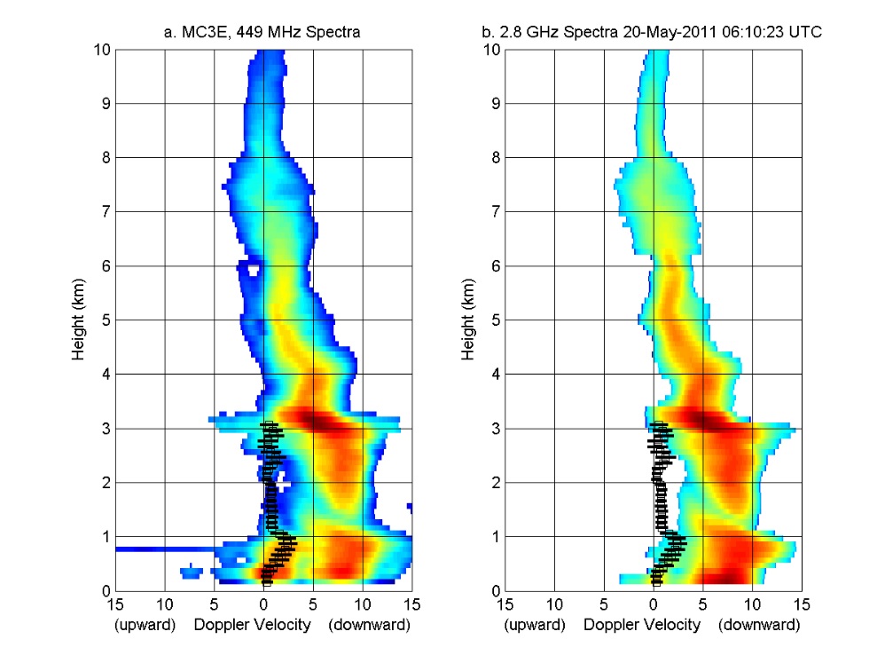
GPM GROUND VALIDATION NOAA UHF 449 PROFILER MC3E V1 recent views
National Aeronautics and Space Administration —
The GPM Ground Validation NOAA UHF 449 Profiler MC3E dataset was collected during the NASA supported Midlatitude Continental Convective Clouds Experiment (MC3E). The... -
Federal
SWOT Level 2 Radiometer Brightness Temperatures and Troposphere Interim Data Product, Version 2.0 recent views
National Aeronautics and Space Administration —
The SWOT Level 2 Radiometer Brightness Temperatures and Troposphere Interim Geophysical Data Record (IGDR) Version 1.0 dataset produced by the Surface Water and Ocean... -
Federal
RSS WindSat L1C Calibrated TB Version 8 recent views
National Aeronautics and Space Administration —
The dataset contains the Level 1C WindSat Top of the Atmosphere (TOA) TB processed by RSS. The WindSat radiances are turned into TOA TB after correction for hot and... -
Federal
GRIP HURRICANE IMAGING RADIOMETER (HIRAD) V0 recent views
National Aeronautics and Space Administration —
The GRIP Hurricane Imaging Radiometer (HIRAD) dataset was collected by the HIRAD instrument, which is a hurricane imaging, single-polarization passive C-band... -
Federal
ACT-America: L1 Meteorological and Aircraft Navigational Data recent views
National Aeronautics and Space Administration —
This dataset provides aircraft navigational parameters and related meteorological data (often referred to as "housekeeping" data) in support of the research... -
Federal
S-MODE DopplerScatt Level 2 Ocean Winds and Currents Version 2 recent views
National Aeronautics and Space Administration —
This dataset contains concurrent airborne DopplerScatt radar retrievals of surface vector winds and ocean currents from the Sub-Mesoscale Ocean Dynamics Experiment... -
Federal
ATom: Flight Dynamics and Environmental Parameters of the NASA DC-8 Aircraft recent views
National Aeronautics and Space Administration —
This dataset contains flight dynamics and environmental parameters (often referred to as housekeeping) specific to the DC-8 aircraft as collected from an assortment...
12 datasets found