
-
Federal
CORONA Satellite Photography recent views
National Aeronautics and Space Administration —
On February 24, 1995, President Clinton signed an Executive Order, directing the declassification of intelligence imagery acquired by the first generation of United... -
Federal
Shuttle Radar Topography Mission DTED Level 1 (3-arc second) Data (DTED-1) recent views
National Aeronautics and Space Administration —
The Shuttle Radar Topography Mission (SRTM) successfully collected Interferometric Synthetic Aperture Radar (IFSAR) data over 80 percent of the landmass of the Earth... -
Federal
Landsat 8 recent views
National Aeronautics and Space Administration —
The Operational Land Imager (OLI) and Thermal Infrared Sensor (TIRS) are onboard the Landsat 8 satellite, have acquired images of the Earth since February 2013. The... -
Federal
NCEP/CPC L3 Half Hourly 4km Global (60S - 60N) Merged IR V1 (GPM_MERGIR) at GES DISC recent views
National Aeronautics and Space Administration —
These data originate from NOAA/NCEP. The NOAA Climate Prediction Center/NCEP/NWS is making the data available originally in binary format, in a weekly rotating... -
Federal
Shuttle Radar Topography Mission 1-arc second Global recent views
National Aeronautics and Space Administration —
The Shuttle Radar Topography Mission (SRTM) was flown aboard the space shuttle Endeavour February 11-22, 2000. The National Aeronautics and Space Administration... -
Federal
USGS Digital Orthophoto Quadrangles recent views
National Aeronautics and Space Administration —
A Digital Orthophoto Quadrangle (DOQ) is a computer-generated image of an aerial photograph in which the image displacement caused by terrain relief and camera tilt... -
Federal
Global Land Cover Characterization Program recent views
National Aeronautics and Space Administration —
The Global Land Cover Characterization Project was established to meet science data requirements identified by the International Geosphere and Biosphere Programme... -
Federal
CYGNSS Level 1 Science Data Record Version 3.2 recent views
National Aeronautics and Space Administration —
This CYGNSS Level 1 (L1) science data record dataset contains the version 3.2 geo-located Delay Doppler Maps (DDMs) calibrated into Power Received (Watts) and... -
Federal
CALIPSO Lidar Level 2 Cloud Profile, V4-20 recent views
National Aeronautics and Space Administration —
CAL_LID_L2_05kmCPro-Standard-V4-20 is the Cloud-Aerosol Lidar and Infrared Pathfinder Satellite Observations (CALIPSO) Lidar Level 2 Cloud Profile, Version 4-20 data... -
Federal
Shuttle Radar Topography Mission (SRTM) Images recent views
National Aeronautics and Space Administration —
Culminating more than four years of processing data, NASA and the National Geospatial-Intelligence Agency (NGA) have completed Earth's most extensive global... -
Federal
Shuttle Radar Topography Mission (SRTM) Version 2 recent views
National Aeronautics and Space Administration —
NASA has released version 2 of the Shuttle Radar Topography Mission digital topographic data (also known as the "finished" version). Version 2 is the result of a... -
Federal
IceBridge GPS/IMU L1B Primary Position and Attitude Solution, Version 1 recent views
National Aeronautics and Space Administration —
This data set contains elevation, roll, pitch, heading, north-south acceleration, east-west acceleration, and vertical acceleration measurements over Antarctica using... -
Federal
SASSIE Arctic Field Campaign Shipboard S-Band Radar Level 3 Data Fall 2022 recent views
National Aeronautics and Space Administration —
This dataset contains images from the S-BAND marine navigation radar collected during the 2022 Salinity and Stratification at the Sea Ice Edge (SASSIE) campaign.... -
Federal
SMAP_L1B_SIGMA_NAUGHT_LOW_RES_V003 recent views
National Aeronautics and Space Administration —
SMAP Level 1B Sigma Naught Low Res Product Version 3 -
Federal
SMEX02 AMSR-E Level 3 Daily Gridded Brightness Temperatures, Iowa, Version 1 recent views
National Aeronautics and Space Administration —
This data set contains Advanced Microwave Scanning Radiometer - Earth Observing System (AMSR-E) level 3 daily gridded brightness temperatures, spatially subsetted to... -
Federal
SMAP_L1B_SIGMA_NAUGHT_LOW_RES_QA_V002 recent views
National Aeronautics and Space Administration —
SMAP Level 1B Sigma Naught Low Res Data Quality Info Version 2 -
Federal
First ISCCP Regional Experiment (FIRE) Cirrus 1 Surface Radiation Budget (SRB) Data over Switzerland recent views
National Aeronautics and Space Administration —
Results from ISCCP analysis of B3 radiance data (sampled to 25 km). Unlike the standard ISCCP product, these data are reported at original pixel resolution and... -
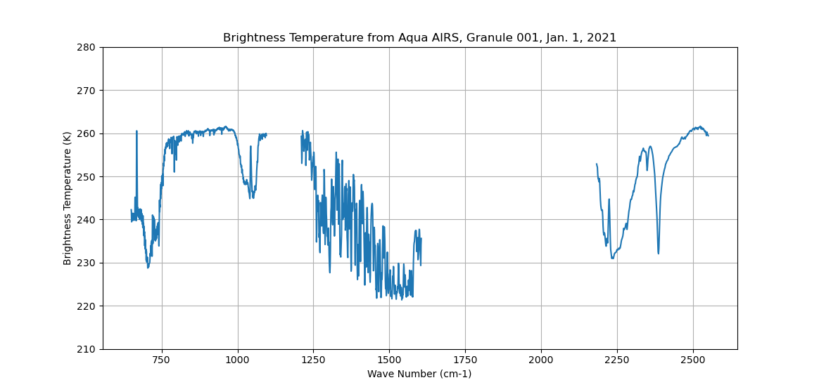
Federal
Sounder SIPS: Sun Synchronous 13:30 orbit Climate Hyperspectral InfraRed Product (CHIRP): Calibrated Radiances from EOS-Aqua, V2 (SNDR13CHRP1AQCal) at GES DISC recent views
National Aeronautics and Space Administration —
The Climate Hyperspectral Infrared Radiance Product (CHIRP) is a Level 1 radiance product derived from Atmospheric Infrared Sounder (AIRS) on EOS-AQUA and the Cross-... -
Federal
SMAPVEX19-22 Massachusetts Vegetation Optical Depth V001 recent views
National Aeronautics and Space Administration —
As part of the SMAPVEX19-22 campaign, an L-band radiometer was deployed on top of a tower at Harvard Forest,Massachusetts, looking down at a stand of red oak forest.... -
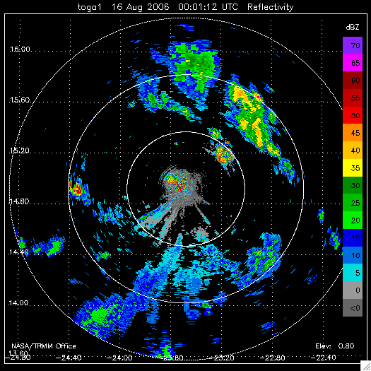
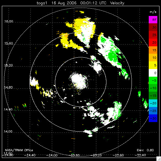
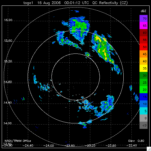
Federal
NAMMA TOGA RADAR DATA V1 recent views
National Aeronautics and Space Administration —
The NAMMA TOGA Radar Data dataset consists of a collection of products derived from the NASA TOGA radar observations that were collected in the Republic of Cape Verde...

Official websites use .gov
A
.gov website belongs to an official government
organization in the United States.
Secure .gov websites use HTTPS
A
lock (
) or https:// means you’ve safely connected to
the .gov website. Share sensitive information only on official,
secure websites.