
-
Federal
SWOT Level 2 Lake Single-Pass Vector Data Product, Version 2.0
National Aeronautics and Space Administration —
The SWOT Level 2 Lake Single-Pass Vector Data Product from the Surface Water Ocean Topography (SWOT) mission provides water surface elevation, area, storage change... -
Federal
USGS Digital Orthophoto Quadrangles
National Aeronautics and Space Administration —
A Digital Orthophoto Quadrangle (DOQ) is a computer-generated image of an aerial photograph in which the image displacement caused by terrain relief and camera tilt... -
Federal
SBU Micro Rain Radar 2 (MRR2) IMPACTS V1
National Aeronautics and Space Administration —
The SBU Micro Rain Radar 2 (MRR-2) IMPACTS dataset consists of reflectivity, Doppler velocity, signal-to-noise ratio, spectral width, droplet size, Liquid Water... -
Federal
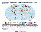
Global Reservoir and Dam Database, Version 1 (GRanDv1): Dams, Revision 01
National Aeronautics and Space Administration —
The Global Reservoir and Dam Database, Version 1, Revision 01 (v1.01) contains 6,862 records of reservoirs and their associated dams with a cumulative storage... -
Federal
SWOT Level 2 Lake Single-Pass Vector Unassigned Data Product, Version 2.0
National Aeronautics and Space Administration —
The SWOT Level 2 Lake Single-Pass Vector Unassigned Data Product from the Surface Water Ocean Topography (SWOT) mission provides water surface elevation, area,... -
Federal
Sentinel-5P TROPOMI Methane CH4 1-Orbit L2 7km x 7km V1 (S5P_L2__CH4___) at GES DISC
National Aeronautics and Space Administration —
Starting from August 6th in 2019, Sentinel-5P TROPOMI along-track high spatial resolution (~5.5km at nadir) has been implemented. For data after August 6th of 2019,... -
Federal
Monthly Historical Water Balance Products for the CONUS
National Aeronautics and Space Administration —
This dataset provides daily historical Water Balance Model outputs from a Thornthwaite-type, single bucket model. Climate inputs to the model are from GridMet daily... -
Federal
VIIRS/NPP Land Surface Temperature and Emissivity 6-Min L2 Swath 750m V001
National Aeronautics and Space Administration —
The NASA/NOAA Suomi National Polar-orbiting Partnership (Suomi NPP) Visible Infrared Imaging Radiometer Suite (VIIRS) Land Surface Temperature and Emissivity... -
Federal
Water Security Indicator Model - Global Land Data Assimilation System (WSIM-GLDAS) Monthly Grids, Version 1
National Aeronautics and Space Administration —
The Water Security Indicator Model - Global Land Data Assimilation System (WSIM-GLDAS) Monthly Grids, Version 1 data set identifies and characterizes surpluses and... -
Federal
SWOT Level 2 KaRIn Low Rate Sea Surface Height Data Product - Unsmoothed, Version 2.0
National Aeronautics and Space Administration —
The SWOT Level 2 KaRIn Low Rate Sea Surface Height Unsmoothed Data Product from the Surface Water Ocean Topography (SWOT) mission provides global sea surface height... -
Federal
Central American Vegetation/Land Cover Classification and Conservation Status
National Aeronautics and Space Administration —
The Central American Vegetation/Land Cover Classification and Conservation Status consists of GIS coverages of vegetation classes (forests, woodlands, savannas,... -
Federal
Sentinel-3A OLCI Regional Mapped Inland Waters (ILW) Data, version 4
National Aeronautics and Space Administration —
The Inland Waters dataset (ILW) provides data for lakes and other water bodies across the contiguous United States (CONUS) and Alaska. ILW significantly reduces the... -
Federal
Scanning Multichannel Microwave Radiometer (SMMR) Monthly Mean Integrated Water Vapor (IWV) By Prabhakara
National Aeronautics and Space Administration —
SMMR_IWV_PRABHAKARA data are Special Multichannel Microwave Radiometer (SMMR) Monthly Mean Integrated Water Vapor (IWV) data by Prabhakara.The Scanning Multichannel... -
Federal
Daily Historical Water Balance Products for the CONUS
National Aeronautics and Space Administration —
This dataset provides daily historical Water Balance Model outputs from a Thornthwaite-type, single bucket model. Climate inputs to the model are from GridMet daily... -
Federal
VIIRS/NPP Surface Reflectance Daily L2G Global 1km and 500m SIN Grid V001
National Aeronautics and Space Administration —
The Visible Infrared Imaging Radiometer Suite (VIIRS) (https://lpdaac.usgs.gov/dataset_discovery/viirs) daily surface reflectance (VNP09GA) Version 1 product provides... -
Federal
TROPICS01 L2B Deep Multispectral INtensity (DMIN) of Tropical Cyclones Estimator Algorithm V1.0
National Aeronautics and Space Administration —
The "Time-Resolved Observations of Precipitation structure and storm Intensity with a Constellation of Smallsats" (TROPICS) mission has a goal of providing nearly... -
Federal
SWOT Level 2 River Single-Pass Vector Reach Data Product, Version 2.0
National Aeronautics and Space Administration —
The SWOT Level 2 River Single-Pass Vector Reach Data Product from the Surface Water Ocean Topography (SWOT) mission provides water surface elevation, slope, width,... -
Federal
THIR/Nimbus-7 Images of Daytime and Nighttime Brightness Temperature on 70 mm Film V001 (THIRN7IM) at GES DISC
National Aeronautics and Space Administration —
THIRN7IM is the Nimbus-7 Temperature-Humidity Infrared Radiometer (THIR) data product consisting of daily montages of brightness temperatures measured at 6.7 and 11.5... -
Federal
Groundswell Spatial Population and Migration Projections at One-Eighth Degree According to SSPs and RCPs, 2010-2050
National Aeronautics and Space Administration —
The Groundswell Spatial Population and Migration Projections at One-Eighth Degree According to SSPs and RCPs, 2010-2050, data set provides a baseline population... -
Federal
Low Elevation Coastal Zone (LECZ) Global Delta Urban-Rural Population and Land Area Estimates, Version 1
National Aeronautics and Space Administration —
The Low Elevation Coastal Zone (LECZ) Global Delta Urban-Rural Population and Land Area Estimates, Version 1 data set provides country-level estimates of urban,...

Official websites use .gov
A
.gov website belongs to an official government
organization in the United States.
Secure .gov websites use HTTPS
A
lock (
) or https:// means you’ve safely connected to
the .gov website. Share sensitive information only on official,
secure websites.