

6 datasets found for "Groundwater"
-
Federal
JPL TELLUS GRACE Level-3 Monthly Land Water-Equivalent-Thickness Surface Mass Anomaly Release 6.0 version 04 in netCDF/ASCII/GeoTIFF Formats
National Aeronautics and Space Administration —
The monthly land mass grids contain water mass anomalies given as equivalent water thickness derived from GRACE & GRACE-FO time-variable gravity observations... -
Federal
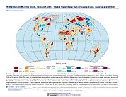
Trends in Global Freshwater Availability from the Gravity Recovery and Climate Experiment (GRACE)
National Aeronautics and Space Administration —
The Trends in Global Freshwater Availability from the Gravity Recovery and Climate Experiment (GRACE), 2002-2016, is a global gridded data set at a spatial resolution... -
Federal
SMAP/SMOS L3 Radiometer 9 km EASE-Grid Soil Moisture V001
National Aeronautics and Space Administration —
The Soil Moisture Active Passive (SMAP, launched in 2015) and the Soil Moisture and Ocean Salinity (SMOS, launched in 2009) missions are each L-band satellites that... -
Federal
Water Security Indicator Model - Global Land Data Assimilation System (WSIM-GLDAS) Monthly Grids, Version 1
National Aeronautics and Space Administration —
The Water Security Indicator Model - Global Land Data Assimilation System (WSIM-GLDAS) Monthly Grids, Version 1 data set identifies and characterizes surpluses and... -
Federal
High Mountain Asia 5 Arc-Minute Hydrological Flow Direction for the Headwaters of the Amu Darya and Indus River Basins V001
National Aeronautics and Space Administration —
TEMP: This High Mountain Asia (HMA) data set consists of a 5 arc-minute hydrological flow network for parts of Afghanistan, Tajikistan, Kyrgyzstan, and Pakistan... -
Federal
SMOS-Based SMAP L2 Radiometer Half-Orbit 9 km EASE-Grid Soil Moisture V001
National Aeronautics and Space Administration —
The Soil Moisture Active Passive (SMAP, launched in 2015) and the Soil Moisture and Ocean Salinity (SMOS, launched in 2009) missions are each L-band satellites that...
6 datasets found for "Groundwater"