
-
Federal
Georeferenced Population Datasets of Mexico (GEO-MEX): GIS of Mexican States, Municipalities and Islands
National Aeronautics and Space Administration —
The GIS of Mexican States, Municipalities and Islands consists of attribute and boundary data for 1990. The attribute data include population, language, education,... -
Federal
Global Human Settlement Layer: Population and Built-Up Estimates, and Degree of Urbanization Settlement Model Grid
National Aeronautics and Space Administration —
The Global Human Settlement Layer: Population and Built-Up Estimates, and Degree of Urbanization Settlement Model Grid data set provides gridded data on human... -
Federal
OPERA Dynamic Surface Water Extent from Harmonized Landsat Sentinel-2 provisional product (Version 1)
National Aeronautics and Space Administration —
This dataset contains Level-3 Dynamic OPERA provisional surface water extent product version 1. The data are provisional surface water extent observations beginning... -
Federal
SMAPVEX08 Land Cover Classification Map V001
National Aeronautics and Space Administration —
This data set consists of land cover classification data derived from satellite imagery and of data obtained in the field as part of the Soil Moisture Active Passive... -
Federal
GPM Ground Validation Dual-frequency Dual-polarized Doppler Radar (D3R) ICE POP V1
National Aeronautics and Space Administration —
The GPM Ground Validation Dual-frequency Dual-polarized Doppler Radar (D3R) ICE POP dataset includes reflectivity, differential reflectivity, copolar correlation... -
Federal
Sentinel-3A OLCI Regional Mapped Inland Waters (ILW) Data, version 4
National Aeronautics and Space Administration —
The Inland Waters dataset (ILW) provides data for lakes and other water bodies across the contiguous United States (CONUS) and Alaska. ILW significantly reduces the... -
Federal
SMAPVEX16 Manitoba PALS Brightness Temperature and Soil Moisture Data V001
National Aeronautics and Space Administration —
This product contains data derived from permanent in situ soil stations and observations by the Passive Active L-band System (PALS) microwave aircraft instrument. The... -
Federal
Sentinel-3A OLCI Regional Binned Inland Waters (ILW) Data, version 4
National Aeronautics and Space Administration —
The Inland Waters dataset (ILW) provides data for lakes and other water bodies across the contiguous United States (CONUS) and Alaska. ILW significantly reduces the... -
Federal
Gridded Species Distribution: Global Amphibian Richness Grids, 2015 Release
National Aeronautics and Space Administration —
The 2015 Release of the Global Amphibian Richness Grids data set of the Gridded Species Distribution collection are aggregations of the presence grids data for the... -
Federal
CLASIC07 Land Cover Classification Map V001
National Aeronautics and Space Administration —
This data set consists of land cover classification data derived from satellite imagery as part of the Cloud and Land Surface Interaction Campaign 2007 (CLASIC07).... -
Federal
SMAPVEX12 Land Cover Classification Map V001
National Aeronautics and Space Administration —
This data set consists of land cover classification data derived from satellite imagery as part of the Soil Moisture Active Passive Validation Experiment 2012... -
Federal
GPM GROUND VALIDATION NASA S-BAND DUAL POLARIMETRIC (NPOL) DOPPLER RADAR MC3E V1
National Aeronautics and Space Administration —
The GPM Ground Validation NASA S-band Dual Polarimetric (NPOL) Doppler Radar MC3E dataset was collected by the NASA NPOL radar, which was developed by a research team... -
Federal
Land Cover Classification, Snow Cover, and Fractional Snow-Covered Area Maps from Maxar WorldView Satellite Images V001
National Aeronautics and Space Administration —
This data set includes: (1) fine-scale snow and land cover maps from two mountainous study sites in the Western U.S., produced using machine-learning models trained... -
Federal
Food Insecurity Hotspots Data Set
National Aeronautics and Space Administration —
The Food Insecurity Hotspots Data Set consists of grids at 250 meter (~7.2 arc-seconds) resolution that identify the level of intensity and frequency of food... -
Federal
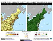
Low Elevation Coastal Zone (LECZ) Urban-Rural Population Estimates, Global Rural-Urban Mapping Project (GRUMP), Alpha Version
National Aeronautics and Space Administration —
The Low Elevation Coastal Zone (LECZ) Urban-Rural Population Estimates consists of country-level estimates of urban, rural and total population and land area country-... -
Federal
National Land Cover Database 2006 (NLCD2006)
National Aeronautics and Space Administration —
National Land Cover Database 2006 (NLCD2006) is a 16-class land cover classification scheme that has been applied consistently across the conterminous United States... -
Federal
MODIS/Terra Global Annual 0.01Deg CMG Snow Cover Climatology V001 NGDA
National Aeronautics and Space Administration —
This data set presents new global snow cover classification regimes derived from the MODIS Terra cloud gap-filled NDSI data (MOD10A1F), elevation, and temperature... -
Federal
Merged Sentinel-3A and Sentinel-3B OLCI Regional Binned Inland Waters (ILW) Data, version 4
National Aeronautics and Space Administration —
The Inland Waters dataset (ILW) provides data for lakes and other water bodies across the contiguous United States (CONUS) and Alaska. ILW significantly reduces the... -
Federal
GPM Ground Validation NEXRAD Level III KMPX IFloodS V1
National Aeronautics and Space Administration —
The GPM Ground Validation NEXRAD Level III KMPX IFloodS dataset contain precipitation products derived from selected NEXt Generation Weather RADar system (NEXRAD)... -
Federal
GPM Ground Validation NEXRAD Level III KDVN IFloodS V1
National Aeronautics and Space Administration —
The GPM Ground Validation NEXRAD Level III KDVN IFloodS dataset contain precipitation products derived from selected NEXt Generation Weather RADar system (NEXRAD)...

Official websites use .gov
A
.gov website belongs to an official government
organization in the United States.
Secure .gov websites use HTTPS
A
lock (
) or https:// means you’ve safely connected to
the .gov website. Share sensitive information only on official,
secure websites.