

7 datasets found for "Birds"
-
Federal
TRMM Ground Validation Calibrated QC Radar Reflectivity Full Volume Scan L1C 1 hour V7 (TRMM_1C51UW) at GES DISC
National Aeronautics and Space Administration —
This dataset is part of the University of Washington TRMM Ground Validation products. Files are in "Universal Format", described in BAMS, Vol 61, No 11, November... -
Federal
TRMM Ground Validation Calibrated QC Radar Reflectivity Full Volume Scan L1C 1 hour V7 (TRMM_1C51) at GES DISC
National Aeronautics and Space Administration —
The purpose of the 1C51 algorithm is to remove non-meteorological radar echoes that adversely affect the quality of higher level products, such as clutter associated... -
Federal
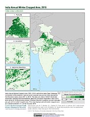
India Annual Winter Cropped Area, 2001-2016 NGDA
National Aeronautics and Space Administration —
The India Annual Winter Cropped Area, 2001 - 2016 consists of annual winter cropped areas for most of India (except the Northeastern states) from 2000-2001 to... -
Federal
Natural Resources Conservation Service SD State Farm Service Agency Color Slide Scans
National Aeronautics and Space Administration —
The unique landscape of South Dakota, known for its diverse wetlands and large areas of native prairie, provides critical habitat for many of the nation’s migratory... -
Federal
High-Resolution QuickBird Imagery and Related GIS Layers for Barrow, Alaska, USA, Version 1
National Aeronautics and Space Administration —
This data set contains high-resolution QuickBird imagery and geospatial data for the entire Barrow QuickBird image area (156.15° W - 157.07° W, 71.15° N - 71.41° N)... -
Federal
High-Resolution Rectified Aerial Photography for Collaborative Research of Environmental Change at Barrow, Alaska, USA, Version 1
National Aeronautics and Space Administration —
This data set includes aerial photography of Barrow, Alaska, which has been geocorrected to a 2002 QuickBird satellite image or Interferometric Synthetic Aperture... -
Federal
Reduced-Resolution QuickBird Imagery and Related GIS Layers for Barrow, Alaska, USA, Version 1
National Aeronautics and Space Administration —
This data set contains reduced-resolution QuickBird imagery and geospatial data for the entire Barrow QuickBird image area 156.15° W - 157.07° W, 71.15° N - 71.41° N)...
7 datasets found for "Birds"