
-
Federal
Shuttle Radar Topography Mission 1-arc second Global
National Aeronautics and Space Administration —
The Shuttle Radar Topography Mission (SRTM) was flown aboard the space shuttle Endeavour February 11-22, 2000. The National Aeronautics and Space Administration... -
Federal
Shuttle Radar Topography Mission (SRTM) Images
National Aeronautics and Space Administration —
Culminating more than four years of processing data, NASA and the National Geospatial-Intelligence Agency (NGA) have completed Earth's most extensive global... -
Federal
Sentinel-1 Single Look Complex (SLC) Bursts
National Aeronautics and Space Administration —
Sentinel-1 Interferometric Wide (IW) and Extra Wide (EW) swath modes are collected using a form of ScanSAR imaging called Terrain Observation with Progressive Scans... -
Federal
SMAP Enhanced L3 Radiometer Global and Polar Grid Daily 9 km EASE-Grid Soil Moisture V006
National Aeronautics and Space Administration —
This enhanced Level-3 (L3) soil moisture product provides a composite of daily estimates of global land surface conditions retrieved by the Soil Moisture Active... -
Federal
AMSR-E L2 Rainfall Subset, collocated with CloudSat track V002 (AMSERR_CPR) at GES DISC
National Aeronautics and Space Administration —
This is a subset of AMSR-E rain rate product along CloudSat field of view track. The goal of the subset is to select and return AMSR-E data that are within -100 km... -
Federal
SMAP Enhanced L3 Radiometer Global and Polar Grid Daily 9 km EASE-Grid Soil Moisture V006
National Aeronautics and Space Administration —
This enhanced Level-3 (L3) soil moisture product provides a composite of daily estimates of global land surface conditions retrieved by the Soil Moisture Active... -
Federal
Spaceborne Imaging Radar-C Precision
National Aeronautics and Space Administration —
Spaceborne Imaging Radar-C/X-band Synthetic Aperture Radar (SIR-C/X-SAR) is a joint project of the National Aeronautics and Space Administration (NASA), the German... -
Federal
Scanning Multichannel Microwave Radiometer (SMMR) Monthly Mean Atmospheric Liquid Water (ALW) By Prabhakara
National Aeronautics and Space Administration —
SMMR_ALW_PRABHAKARA data are Special Multichannel Microwave Radiometer (SMMR) Monthly Mean Atmospheric Liquid Water (ALW) data by Prabhakara.The Prabhakara Scanning... -
Federal
SWOT Level 1B High-Rate Single-look Complex Data Product, Version 2.0
National Aeronautics and Space Administration —
High rate data processed to single-look complex SAR images for each antenna. Gridded tile (approx 64x64 km2); half swath (left or right side of full swath). Available... -
Federal
SMAP Enhanced L3 Radiometer Global and Northern Hemisphere Daily 9 km EASE-Grid Freeze/Thaw State V004
National Aeronautics and Space Administration —
This enhanced Level-3 (L3) product provides a daily composite of global and Northern Hemisphere landscape freeze/thaw conditions retrieved by the Soil Moisture Active... -
Federal
Supporting Information for Very Long Baseline Interferometry (VLBI) Data and Products from NASA CDDIS
National Aeronautics and Space Administration —
Very Long Baseline Interferometry (VLBI) is a geometric technique: it measures the time difference between the arrival at two Earth-based antennas of a radio... -
Federal
SnowEx17 Ground-Based UWScat Ku- and X-Band Frequency Modulated Continuous Wave Radar V001
National Aeronautics and Space Administration —
This data set consists of ground-based scatterometer data acquired during the SnowEx 2017 campaign at Grand Mesa, Colorado, USA, a snow-covered, forested study site... -
Federal
Near Real-time SMAP L2 Radiometer Half-Orbit 36 km EASE-Grid Soil Moisture V107
National Aeronautics and Space Administration —
This Near Real-Time (NRT) data set corresponds to the standard SMAP L2 Radiometer Half-Orbit 36 km EASE-Grid Soil Moisture (SPL2SMP) product. The data provide... -
Federal
Near Real-time SMAP L1B Radiometer Half-Orbit Time-Ordered Brightness Temperatures V105
National Aeronautics and Space Administration —
This Near Real-Time (NRT) data set corresponds to the standard SMAP L1B Radiometer Half-Orbit Time-Ordered Brightness Temperatures (SPL1BTB) product. The data provide... -
Federal
TRMM Ground Validation Calibrated QC Radar Reflectivity Full Volume Scan L1C 1 hour V7 (TRMM_1C51) at GES DISC
National Aeronautics and Space Administration —
The purpose of the 1C51 algorithm is to remove non-meteorological radar echoes that adversely affect the quality of higher level products, such as clutter associated... -
Federal
SMAP Enhanced L3 Radiometer Global and Northern Hemisphere Daily 9 km EASE-Grid Freeze/Thaw State V004
National Aeronautics and Space Administration —
This enhanced Level-3 (L3) product provides a daily composite of global and Northern Hemisphere landscape freeze/thaw conditions retrieved by the Soil Moisture Active... -
Federal
SMAP Enhanced L2 Radiometer Half-Orbit 9 km EASE-Grid Soil Moisture V006
National Aeronautics and Space Administration —
This enhanced Level-2 (L2) product contains calibrated, geolocated, brightness temperatures acquired by the Soil Moisture Active Passive (SMAP) radiometer during 6:00... -
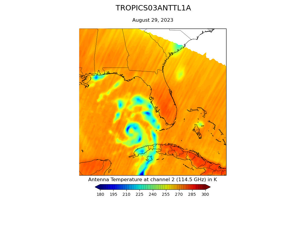
Federal
TROPICS01 Pathfinder L1A Orbital Geolocated Native-Resolution Antenna Temperatures V1.0
National Aeronautics and Space Administration —
The "Time-Resolved Observations of Precipitation structure and storm Intensity with a Constellation of Smallsats" (TROPICS) mission has a goal of providing nearly... -
Federal
SMAP Enhanced L1C Radiometer Half-Orbit 9 km EASE-Grid Brightness Temperatures V004
National Aeronautics and Space Administration —
This enhanced Level-1C (L1C) product contains calibrated and geolocated brightness temperatures acquired by the Soil Moisture Active Passive (SMAP) radiometer during... -
Federal
TROPICS05 L1A Orbital Geolocated Native-Resolution Antenna Temperatures V0.2
National Aeronautics and Space Administration —
The "Time-Resolved Observations of Precipitation structure and storm Intensity with a Constellation of Smallsats" (TROPICS) mission has a goal of providing nearly...

Official websites use .gov
A
.gov website belongs to an official government
organization in the United States.
Secure .gov websites use HTTPS
A
lock (
) or https:// means you’ve safely connected to
the .gov website. Share sensitive information only on official,
secure websites.