

8 datasets found for "Animals"
-
Federal
Global Fertilizer and Manure, Version 1: Nitrogen in Manure Production
National Aeronautics and Space Administration —
The Nitrogen in Manure Production data set of the Global Fertilizer and Manure, Version 1 Data Collection represents the amount of nitrogen manure produced and... -
Federal
MEaSUREs ITS_LIVE Greenland Monthly 120 m Ice Sheet Extent Masks, 1972-2022 V001
National Aeronautics and Space Administration —
This ITS_LIVE data set, part of the Making Earth System Data Records for Use in Research Environments (MEaSUREs) Program, contains monthly, 120 m resolution ice masks... -
Federal
GPM GROUND VALIDATION NASA ER-2 NAVIGATION DATA MC3E V1
National Aeronautics and Space Administration —
The GPM Ground Validation NASA ER-2 Navigation Data MC3E dataset contains information recorded by an on board navigation recorder (NavRec). In addition to typical... -
Federal
Global Fertilizer and Manure, Version 1: Phosphorus in Manure Production
National Aeronautics and Space Administration —
The Phosphorus in Manure Production data set of the Global Fertilizer and Manure, Version 1 Data Collection represents the amount of phosphorous in manure produced... -
Federal
Gridded Species Distribution: Global Amphibian Richness Grids, 2015 Release
National Aeronautics and Space Administration —
The 2015 Release of the Global Amphibian Richness Grids data set of the Gridded Species Distribution collection are aggregations of the presence grids data for the... -
Federal
West Africa Coastal Vulnerability Mapping: Subset of Global Mammal and Amphibian Richness Grids, 2015 Release
National Aeronautics and Space Administration —
The West Africa Coastal Vulnerability Mapping: Subset of Global Mammal and Amphibian Richness Grids, 2015 Release was extracted from the NASA Socioeconomic Data and... -
Federal
Gridded Species Distribution: Global Mammal Richness Grids, 2015 Release
National Aeronautics and Space Administration —
The 2015 Release of the Global Mammal Richness Grids data set of the Gridded Species Distribution collection are aggregations of the presence grids data for the... -
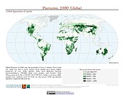
Federal
Global Agricultural Lands: Pastures, 2000
National Aeronautics and Space Administration —
The Global Pastures data set represents the proportion of land areas used as pasture land (land used to support grazing animals) in the year 2000. Satellite data from...
8 datasets found for "Animals"