
-
Federal
Deciduous Fractional Cover and Tree Canopy Cover for Boreal North America, 1992-2015
National Aeronautics and Space Administration —
This dataset holds deciduous fraction and tree canopy cover at 30-m resolution over the North American boreal domain for 1992 to 2015. Deciduous fraction is the areal... -
Federal
SMAPVEX19-22 Massachusetts Vegetation Optical Depth V001
National Aeronautics and Space Administration —
As part of the SMAPVEX19-22 campaign, an L-band radiometer was deployed on top of a tower at Harvard Forest,Massachusetts, looking down at a stand of red oak forest.... -
Federal
NOAA-20 VIIRS Global Binned Inherent Optical Properties (IOP) Data, version R2022.0
National Aeronautics and Space Administration —
The Visible and Infrared Imager/Radiometer Suite (VIIRS) is a multi-disciplinary instrument that is being flown on the Joint Polar Satellite System (JPSS) series of... -
Federal
NOAA-20 VIIRS Regional Inherent Optical Properties (IOP) Data, version R2022.0
National Aeronautics and Space Administration —
The Visible and Infrared Imager/Radiometer Suite (VIIRS) is a multi-disciplinary instrument that is being flown on the Joint Polar Satellite System (JPSS) series of... -
Federal
GPM Ground Validation Kumpula Mast Meteorological Data LPVEx V1
National Aeronautics and Space Administration —
The GPM Ground Validation Kumpula Mast Meteorological Data LPVEx dataset is comprised of temperature, radiation, and wind measurements collected by the Station for... -
Federal
USGS Digital Orthophoto Quadrangles
National Aeronautics and Space Administration —
A Digital Orthophoto Quadrangle (DOQ) is a computer-generated image of an aerial photograph in which the image displacement caused by terrain relief and camera tilt... -
Federal
Spectral Reflectance and Ancillary Data, Tundra Transect, North Slope, AK, 2000-2022
National Aeronautics and Space Administration —
This dataset provides visible-near infrared spectral reflectance, descriptions of vegetation cover, surface temperature, the total fraction of absorbed... -
Federal
PalEON: Terrestrial Ecosystem Model Drivers for the Northeastern U.S., 0850-2010
National Aeronautics and Space Administration —
This dataset from the PalEON Ecosystem Model Intercomparison Project (PEMIP) provides harmonized regional environmental and meteorological drivers at a resolution of... -
Federal
CERES and GEO-Enhanced TOA, Within-Atmosphere, and Surface Fluxes Clouds and Aerosols Monthly Terra Edition4A NGDA
National Aeronautics and Space Administration —
CER_SYN1deg-Month_Terra-MODIS_Edition4A is the Clouds and the Earth's Radiant Energy System (CERES) and and geostationary (GEO)-Enhanced Top of Atmosphere (TOA),... -
Federal
CERES and GEO-Enhanced TOA, Within-Atmosphere and Surface Fluxes, Clouds and Aerosols Three-Hourly Terra-NPP Edition1A NGDA
National Aeronautics and Space Administration —
CER_SYN1deg-3Hour_Terra-NPP_Edition1A is the Clouds and the Earth's Radiant Energy System (CERES) and geostationary (GEO)-Enhanced Top-of-Atmosphere (TOA), Within-... -
Federal
Visible Infrared Imager-Radiometer Suite NPP Level-2 Normalized Difference Vegetation Index Land Reflectance Data Version 2014
National Aeronautics and Space Administration —
Product Title: Visible Infrared Imager-Radiometer Suite NPP Level-2 The Visible and Infrared Imager/Radiometer Suite (VIIRS) is a multi-disciplinaryinstrument that is... -
Federal
NAFD-ATT Forest Canopy Cover Loss from Landsat, CONUS, 1986-2010
National Aeronautics and Space Administration —
Characterizing the cause of forest canopy changes through time is fundamental to understanding current and future forest functions. A better understanding of forest... -
Federal
Suomi-NPP VIIRS Global Mapped Inherent Optical Properties (IOP) Data, version R2022.0
National Aeronautics and Space Administration —
The Visible and Infrared Imager/Radiometer Suite (VIIRS) is a multi-disciplinary instrument that is being flown on the Joint Polar Satellite System (JPSS) series of... -
Federal
NPP Grassland: Kurukshetra, India, 1970-1971, R1
National Aeronautics and Space Administration —
This data set contains two ASCII files (.txt format). One file contains above- and below-ground biomass (including standing dead material and litter) and productivity... -
Federal
BOREAS TE-05 Leaf Carbon Isotope Data
National Aeronautics and Space Administration —
Contains leaf carbon isotope data collected by TE-05 during 1994. -
Federal
BOREAS RSS-02 Extracted Reflectance Factors Derived from ASAS Imagery
National Aeronautics and Space Administration —
Contains calculated bidirectional reflectance factor means derived from extractions of C130-based ASAS measurements made during BOREAS. -
Federal
BOREAS/SRC AMS Suite A Surface Meteorological and Radiation Data: 1996
National Aeronautics and Space Administration —
Contains the data collected in 1996 by the AMS suite A instrument set operated by SRC and provided to BORIS. -
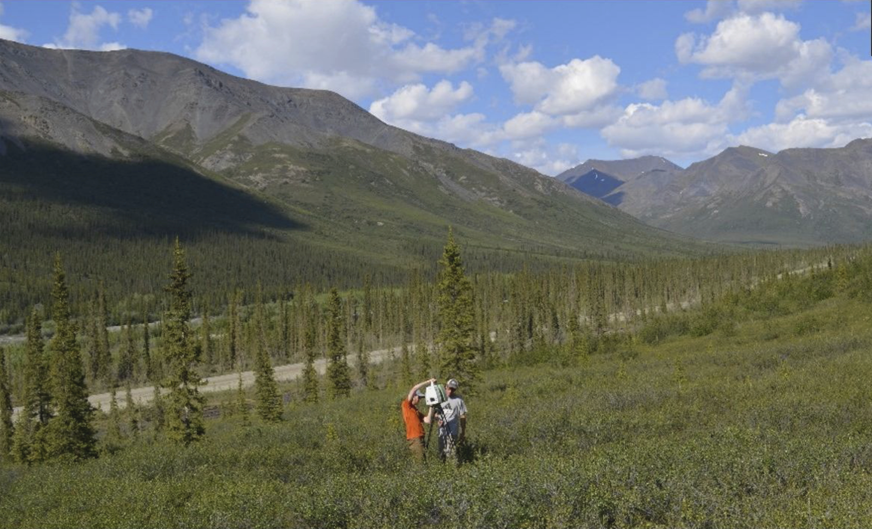
Federal
ABoVE: Terrestrial Lidar Scanning Forest-Tundra Ecotone, Brooks Range, Alaska, 2016
National Aeronautics and Space Administration —
This dataset provides terrestrial lidar scanning (TLS) point cloud data collected at 10 research plots along the forest-tundra ecotone (FTE) in the Brooks Range of... -
Federal
BOREAS Daedalus TMS Level-0 Imagery: Digital Counts in BIL Format
National Aeronautics and Space Administration —
The level-0 Daedalus TMS imagery, along with the other remotely sensed images, was collected to provide spatially extensive information about radiant energy over the...

Official websites use .gov
A
.gov website belongs to an official government
organization in the United States.
Secure .gov websites use HTTPS
A
lock (
) or https:// means you’ve safely connected to
the .gov website. Share sensitive information only on official,
secure websites.