
-
Federal
Global Reservoir and Dam Database, Version 1 (GRanDv1): Dams, Revision 01
National Aeronautics and Space Administration —
The Global Reservoir and Dam Database, Version 1, Revision 01 (v1.01) contains 6,862 records of reservoirs and their associated dams with a cumulative storage... -
Federal
Global Gridded Geographically Based Economic Data (G-Econ), Version 4
National Aeronautics and Space Administration —
The Global Gridded Geographically Based Economic Data (G-Econ), Version 4 contains derived one degree grid cells of Gross Domestic Product (GDP) data in Grid and... -
Federal
GRACE-FO Level-2 Monthly Geopotential Spherical Harmonics GFZ Release 6.1 (RL06.1)
National Aeronautics and Space Administration —
FOR EXPERT USE ONLY. This dataset contains estimates of the total month-by-month geopotential of the Earth, derived from the Gravity Recovery and Climate Experiment... -
Federal
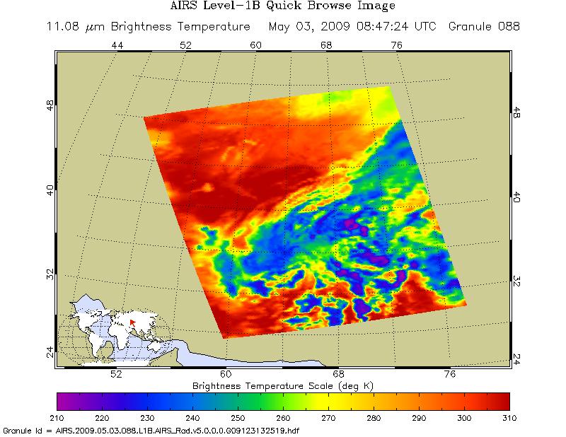
AIRS/Aqua L1B Infrared (IR) geolocated and calibrated radiances V005 (AIRIBRAD) at GES DISC at GES DISC
National Aeronautics and Space Administration —
WARNING: On 2021/09/23 the EOS Aqua executed a Deep Space Maneuver (DSM). In the DSM, the spacecraft is turned such that the normal Earth field of regard is deep... -
Federal
OSCAR third degree resolution ocean surface currents - yearly files
National Aeronautics and Space Administration —
OSCAR (Ocean Surface Current Analysis Real-time) contains near-surface ocean current estimates, derived using quasi-linear and steady flow momentum equations. The... -
Federal
SPURS-2 Passive Accoustic Listener (PAL) data from ARGO float deployments during the E. Tropical Pacific field campaign
National Aeronautics and Space Administration —
The SPURS (Salinity Processes in the Upper Ocean Regional Study) project is a NASA-funded oceanographic process study and associated field program that aim to... -
Federal
CAR ECO3D BRDF Measurements V2 (CAR_ECO3D_BRDF) at GES DISC
National Aeronautics and Space Administration —
This study provide critical measurements on 3-dimensional structure of vegetation, which is important for quantifying the amount of carbon stored in biomass. It... -
Federal
West Africa Coastal Vulnerability Mapping: Point and Gridded Locations of Fatalities, 2008-2013
National Aeronautics and Space Administration —
The West Africa Coastal Vulnerability Mapping: Point and Gridded Locations of Fatalities, 2008-2013 data set consists of two layers: points representing the location... -
Federal
GRIP HURRICANE IMAGING RADIOMETER (HIRAD) V1
National Aeronautics and Space Administration —
The GRIP Hurricane Imaging Radiometer (HIRAD) V1 dataset contains measurements of brightness temperature taken at 4, 5, 6 and 6.6 GHz, as well as MERRA 2 m wind speed... -
Federal
OCO-2 Level 2 spatially ordered geolocated retrievals screened using the A-band Preprocessor, Retrospective Processing V10r (OCO2_L2_ABand) at GES DISC
National Aeronautics and Space Administration —
Version 10r is the current version of the data set. Older versions will no longer be available and are superseded by Version 10r. In early 2021, the OCO Team... -
Federal
CAR Kuwait Oil Fire Spectral Reflectance L1 V1 (CAR_KUWAITOILFIRE_L1C) at GES DISC
National Aeronautics and Space Administration —
CAR Kuwait Oil Fire mission measured bidirectional reflectance function of smoke from Kuwait oil fires during the Kuwait Oil Fire Smoke Experiment. Measurements were... -
Federal
CSR TELLUS GRACE-FO Level-3 Monthly Ocean Bottom Pressure Anomaly Release 6.1 version 04
National Aeronautics and Space Administration —
The monthly ocean bottom pressure anomaly grids are given as equivalent water thickness changes derived from GRACE & GRACE-FO time-variable gravity observations... -
Federal
NSCAT Gridded Level 3 Enhanced Resolution Sigma-0 from BYU
National Aeronautics and Space Administration —
This NASA Scatterometer (NSCAT) satellite Sigma-0 dataset is generated by the Scatterometer Climate Record Pathfinder (SCP) project at Brigham Young University (BYU)... -
Federal
GHRSST Level 3C North Atlantic Regional (NAR) subskin Sea Surface Temperature from Metop/AVHRR (GDS V2) produced by OSI SAF
National Aeronautics and Space Administration —
A Group for High Resolution Sea Surface Temperature (GHRSST) dataset for the North Atlantic Region (NAR) derived from the Advanced Very High Resolution Radiometer... -
Federal
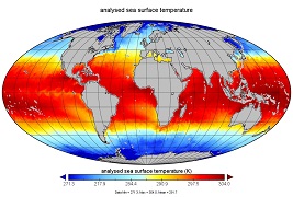
GHRSST Level 4 MW_OI Global Foundation Sea Surface Temperature analysis version 5.1 from REMSS
National Aeronautics and Space Administration —
A Group for High Resolution Sea Surface Temperature (GHRSST) global Level 4 sea surface temperature analysis produced daily on a 0.25-degree grid at Remote Sensing... -
Federal
Aquarius Official Release Level 3 Sea Surface Density Standard Mapped Image Ascending Monthly Data V5.0
National Aeronautics and Space Administration —
Aquarius Level 3 sea surface density standard mapped image data contains gridded 1 degree spatial resolution density data averaged over daily, 7 day, monthly, and... -
Federal
ABoVE: Environmental Conditions and Subsistence Resource Access, Alaska, 2016-2017
National Aeronautics and Space Administration —
This dataset provides descriptions and photos of environmental conditions that impacted availability to subsistence resources by residents in nine rural communities... -
Federal
Probabilistic Freeze-Thaw Record for the Northern Hemisphere, 2016-2020
National Aeronautics and Space Administration —
This dataset provides a probabilistic freeze/thaw (FT) data record from 2016 to 2020 for the Northern Hemisphere derived using a deep learning model (U-Net). The... -
Federal
Vulcan: High-Resolution Annual Fossil Fuel CO2 Emissions in USA, 2010-2015, Version 3
National Aeronautics and Space Administration —
The Vulcan version 3.0 annual dataset provides estimates of annual carbon dioxide (CO2) emissions from the combustion of fossil fuels (FF) and CO2 emissions from...

Official websites use .gov
A
.gov website belongs to an official government
organization in the United States.
Secure .gov websites use HTTPS
A
lock (
) or https:// means you’ve safely connected to
the .gov website. Share sensitive information only on official,
secure websites.