
-
Federal
MODIS/Terra Atmospherically Corrected Surface Reflectance 5-Min L2 Swath 250m, 500m, 1km NGDA
National Aeronautics and Space Administration —
The MODIS/Terra Atmospherically Corrected Surface Reflectance 5-Min L2 Swath 250m, 500m, 1km (MOD09) product is computed from the MODIS Level 1B land bands 1, 2, 3,... -
Federal
GEDI L1B Geolocated Waveform Data Global Footprint Level V002
National Aeronautics and Space Administration —
The Global Ecosystem Dynamics Investigation (GEDI) mission aims to characterize ecosystem structure and dynamics to enable radically improved quantification and... -
Federal
Decadal Land Use and Land Cover Classifications across India, 1985, 1995, 2005
National Aeronautics and Space Administration —
This data set provides land use and land cover (LULC) classification products at 100-m resolution for India at decadal intervals for 1985, 1995 and 2005. The data... -
Federal
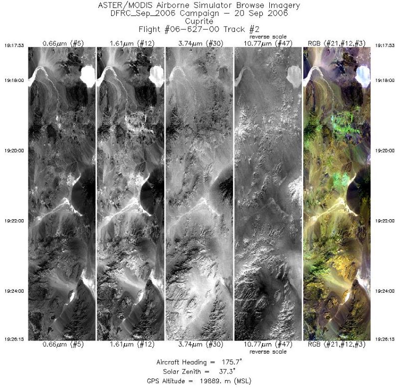
MASTER: Airborne Science, Western US, September, 2006
National Aeronautics and Space Administration —
This dataset includes Level 1B (L1B) and Level 2 (L2) data products from the MODIS/ASTER Airborne Simulator (MASTER) instrument. The spectral data were collected... -
Federal
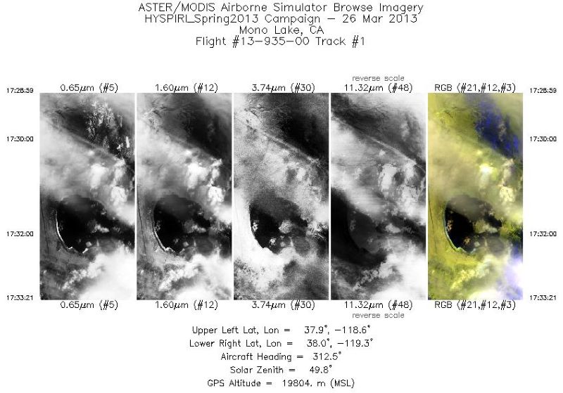
MASTER: HyspIRI Airborne Campaign, California, Early Spring 2013, V2
National Aeronautics and Space Administration —
This dataset includes Level 1B (L1B) and Level 2 (L2) data products from the MODIS/ASTER Airborne Simulator (MASTER) instrument. The spectral data were collected as... -
Federal
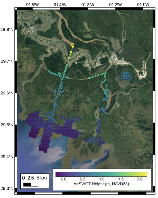
Delta-X: AirSWOT L3 Water Surface Elevations, MRD, Louisiana, 2021
National Aeronautics and Space Administration —
This dataset contains water surface elevations at selected point locations generated from the AirSWOT data collected during the Spring and Fall 2021 Delta-X... -
Federal
Catalog of boreholes from Russia and Mongolia, Version 1
National Aeronautics and Space Administration —
This catalog of boreholes from across Russia and Mongolia includes those published in papers and monographs as well as other literature of limited circulation. The... -
Federal
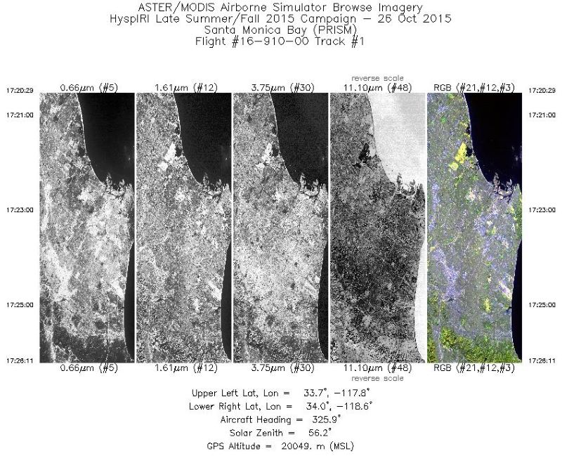
MASTER: HyspIRI Airborne Campaign, California, Fall 2015
National Aeronautics and Space Administration —
This dataset includes Level 1B (L1B) and Level 2 (L2) data products from the MODIS/ASTER Airborne Simulator (MASTER) instrument. The spectral data were collected as... -
Federal
ACTIVATE Merged MODIS and MERRA-2 Dataset NGDA
National Aeronautics and Space Administration —
ACTIVATE-MODIS-MERRA2 is the merged CERES MODIS and MERRA-2 dataset (pixel-level geostationary cloud products) produced by SatCORPS group at NASA Langley Research... -
Federal
AfriSAR: Canopy Structure Derived from PolInSAR and Coherence TomoSAR NISAR tools
National Aeronautics and Space Administration —
This dataset contains forest vertical structure and associated uncertainty products derived by applying multi-baseline Polarimetric Interferometric Synthetic Aperture... -
Federal
CERES MODIS Cloud Retrievals in ISCCP-D2like Format Nighttime Aqua FM4 Edition3A NGDA
National Aeronautics and Space Administration —
CER_ISCCP-D2like-Nit_Aqua-FM4-MODIS_Edition3A is the Clouds and the Earth's Radiant Energy System (CERES) Moderate Resolution Imaging Spectroradiometer (MODIS) Cloud... -
Federal
MISR Level 3 Component Global Land Product covering a year V004
National Aeronautics and Space Administration —
MIL3YLS_4 is the Multi-angle Imaging SpectroRadiometer (MISR) Level 3 Component Global Land Product covering a year version 4. It contains a statistical summary of... -
Federal
LBA-ECO TG-07 Trace Gas Fluxes, Undisturbed and Logged Sites, Para, Brazil: 2000-2002
National Aeronautics and Space Administration —
Trace gas fluxes of carbon dioxide, methane, nitrous oxide, and nitric oxide were measured manually at undisturbed and logged forest sites in the Tapajos National... -
Federal
CAR LEADEX Arctic Sea Ice and Tundra BRDF Measurements L1 V2 (CAR_LEADEX_BRDF) at GES DISC
National Aeronautics and Space Administration —
CAR LEADEX mission measured bidirectional reflectance functions for four common arctic surfaces: snow covered sea ice, melt season sea ice, snow covered tundra, and... -
Federal
CEOS Cal Val Test Site - Ivanpah Playa, USA - Instrumented Site NGDA
National Aeronautics and Space Administration —
On the background of these requirements for sensor calibration, intercalibration and product validation, the subgroup on Calibration and Validation of the Committee... -
Federal
MISR Level 2 Land Surface Product subset for the VBBE region V002
National Aeronautics and Space Administration —
Multi-angle Imaging SpectroRadiometer (MISR) is an instrument designed to view Earth with cameras pointed in 9 different directions. As the instrument flies overhead,... -
Federal
CAR FIREACE Arctic Ice and Cloud Radiation BRDF V2 (CAR_FIREACE_BRDF) at GES DISC
National Aeronautics and Space Administration —
The scientific objectives of FIRE/ACE are to study impact of Arctic clouds on radiation exchange between surface, atmosphere, and space, and the influence of surface... -
Federal
Combined ASTER and MODIS Emissivity database over Land (CAMEL) Emissivity Monthly Global 0.05Deg V001 NGDA
National Aeronautics and Space Administration —
The NASA Making Earth System Data Records for Use in Research Environments (MEaSUREs) (https://earthdata.nasa.gov/community/community-data-system-programs/measures-...

Official websites use .gov
A
.gov website belongs to an official government
organization in the United States.
Secure .gov websites use HTTPS
A
lock (
) or https:// means you’ve safely connected to
the .gov website. Share sensitive information only on official,
secure websites.