
-
Federal
OMPS-NPP L1G LP Radiance EV Wavelength-Altitude Grid swath orbital 3slit V2.6 (OMPS_NPP_LP_L1G_EV) at GES DISC recent views
National Aeronautics and Space Administration —
The OMPS-NPP L1G LP Radiance EV Wavelength-Altitude Grid swath orbital 3slit product contains the calibrated earth-viewing radiances measured by the Ozone Mapping and... -
Federal
Aquarius Official Release Level 3 Sea Surface Spiciness Standard Mapped Image Ascending 28-Day Running Mean Data V5.0 recent views
National Aeronautics and Space Administration —
Aquarius Level 3 sea surface salinity spiciness standard mapped image data contains gridded 1 degree spatial resolution spice data averaged over daily, 7 day,... -
Federal
NOAA Fisheries Ecosystem Monitoring Program recent views
National Aeronautics and Space Administration —
EcoMon is the NOAA Northeast Fisheries Science Center Ecosystem Monitoring program for the Northeast U.S. continental shelf. EcoMon main objective is hydrography and... -
Federal
JPL GRACE and GRACE-FO Mascon Ocean, Ice, and Hydrology Equivalent Water Height Coastal Resolution Improvement (CRI) Filtered Release 06.1 Version 03 recent views
National Aeronautics and Space Administration —
This dataset contains gridded monthly global water storage/height anomalies relative to a time-mean, derived from GRACE and GRACE-FO and processed at JPL using the... -
Federal
Sea Ice Concentrations from Nimbus-7 SMMR and DMSP SSM/I-SSMIS Passive Microwave Data V002 recent views
National Aeronautics and Space Administration —
This data set is generated from brightness temperature data and is designed to provide a consistent time series of sea ice concentrations spanning the coverage of... -
Federal
VIIRS NOAA-20 (JPSS-1) 375m, I-Band Active Fire Product NRT (Vector Data) recent views
National Aeronautics and Space Administration —
Near real-time (NRT) NOAA-20 (formally JPSS-1) Visible Infrared Imaging Radiometer Suite (VIIRS) Active Fire detection product is based on the instrument's 375 m... -
Federal
MISR Level 3 Cloud Fraction by Altitude Product covering a month V001 recent views
National Aeronautics and Space Administration —
MIL3MCFA_1 is the Multi-angle Imaging SpectroRadiometer (MISR) Level 3 Cloud Fraction by Altitude Product covering a month version 1. It provides the frequency of... -
Federal
MISR Ancillary Geographic Product V001 recent views
National Aeronautics and Space Administration —
MIANCAGP_1 is the Multi-angle Imaging SpectroRadiometer (MISR) Ancillary Geographic Product version 1. It is a set of 233 pre-computed files. Each AGP file pertains... -
Federal
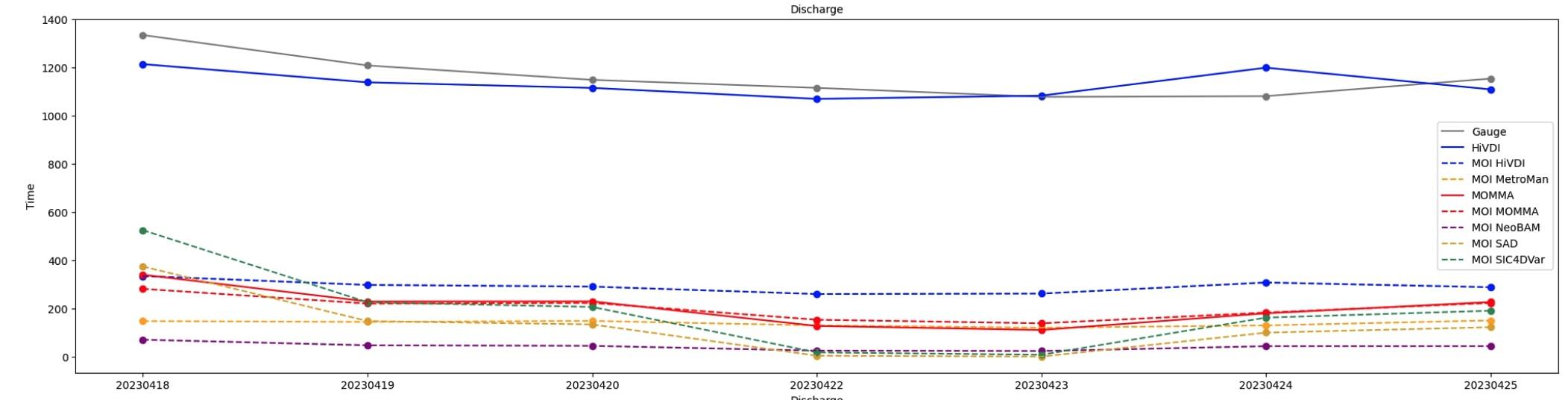
SWOT Sword of Science River Discharge Products Version 1 recent views
National Aeronautics and Space Administration —
The SWOT Sword of Science River Discharge Products dataset from the Surface Water and Ocean Topography (SWOT) mission and produced by the Discharge Algorithm Working... -
Federal
GRACE-FO Level-2 Monthly Geopotential Spherical Harmonics GFZ Release 6.1 (RL06.1) recent views
National Aeronautics and Space Administration —
FOR EXPERT USE ONLY. This dataset contains estimates of the total month-by-month geopotential of the Earth, derived from the Gravity Recovery and Climate Experiment... -
Federal
MISR Ancillary Radiometric Product V002 recent views
National Aeronautics and Space Administration —
MIANCARP_2 is the Multi-angle Imaging SpectroRadiometer (MISR) Ancillary Radiometric Product version 2. It is composed of 4 files covering instrument characterization... -
Federal
MISR Level 2 Surface parameters V002 recent views
National Aeronautics and Space Administration —
MIL2ASLS_2 is the Multi-angle Imaging SpectroRadiometer (MISR) Level 2 Land Surface parameters version 2 data product. It contains a variety of information on the... -
Federal
Airborne Multi-angle Imaging SpectroRadiometer (AirMISR) Data from the SERC 2003 Campaign recent views
National Aeronautics and Space Administration —
The AIRMISR_SERC_2003 data were acquired during a flight over the Smithsonian Environmental Research Center, Maryland, USA, target as part of the AirMISR deployments... -
Federal
Airborne Multi-angle Imaging SpectroRadiometer (AirMISR) Data from the Snow and Ice 2001 Campaign recent views
National Aeronautics and Space Administration —
The AIRMISR_SNOW_ICE_2001 data were acquired during the Colorado snow albedo field experiment in the Yampa Valley of Colorado during February and March, 2001. This... -
Federal
Airborne Multi-angle Imaging SpectroRadiometer (AirMISR) Data from the Roger's Lake 2001 Campaign recent views
National Aeronautics and Space Administration —
The AIRMISR_ROGERS_LAKE_2001 data were acquired during a flight over Roger's Lake, California on June 6, 2001. The Jet Propulsion Laboratory (JPL) in Pasadena,... -
Federal
TES/Aura L3 Ozone Daily Gridded V006 recent views
National Aeronautics and Space Administration —
TL3O3D_6 is the Tropospheric Emission Spectrometer (TES)/Aura L3 Ozone Daily Gridded Version 6 data product. TES was an instrument aboard NASA's Aura satellite and... -
Federal
Airborne Multi-angle Imaging SpectroRadiometer (AirMISR) Data from the Monterey 1999 Campaign recent views
National Aeronautics and Space Administration —
The AIRMISR_MONTEREY_1999 data were acquired on June 29, 1999 during a field mission which focused on Monterey, California. The Jet Propulsion Laboratory (JPL) in... -
Federal
MISR Level 3 Component Global Aerosol Regional public Product covering a day V002 recent views
National Aeronautics and Space Administration —
MI3DAER_2 is the Multi-angle Imaging SpectroRadiometer (MISR) Level 3 Component Global Aerosol Regional public Product covering a day version 2. It contains a... -
Federal
TES/Aura L3 Water Vapor Monthly Gridded V005 recent views
National Aeronautics and Space Administration —
TL3H2OM_5 is the Tropospheric Emission Spectrometer (TES)/Aura Level 3 Water Vapor Monthly Gridded Version 5 data product. TES was an instrument aboard NASA's Aura... -
Federal
MISR Level 1A Calibration Data V002 recent views
National Aeronautics and Space Administration —
MI1AC_2 is the Multi-angle Imaging SpectroRadiometer (MISR) Level 1A Calibration data in DN. The data numbers have been commuted from 12-bit numbers to 16-bit, byte...

Official websites use .gov
A
.gov website belongs to an official government
organization in the United States.
Secure .gov websites use HTTPS
A
lock (
) or https:// means you’ve safely connected to
the .gov website. Share sensitive information only on official,
secure websites.