
-
Federal
NOAA-21 VIIRS Global Binned Particulate Inorganic Carbon (PIC) Data, version R2022.0
National Aeronautics and Space Administration —
The Visible and Infrared Imager/Radiometer Suite (VIIRS) is a multi-disciplinary instrument that is being flown on the Joint Polar Satellite System (JPSS) series of... -
Federal
MISR Level 1B2 Ellipsoid Data subset for the UAE region V003
National Aeronautics and Space Administration —
Multi-angle Imaging SpectroRadiometer (MISR) is an instrument designed to view Earth with cameras pointed in 9 different directions. As the instrument flies overhead,... -
Federal
TES/Aura L3 HNO3 Monthly Gridded V004
National Aeronautics and Space Administration —
TL3HNOM_4 is the Tropospheric Emission Spectrometer (TES)/Aura Level 2 Atmospheric Temperatures Limb Version 4 data product. It consists of monthly averages of... -
Federal
MISR Level 1B2 Ellipsoid Product subset for the GoMACCS region V003
National Aeronautics and Space Administration —
Multi-angle Imaging SpectroRadiometer (MISR) is an instrument designed to view Earth with cameras pointed in 9 different directions. As the instrument flies overhead,... -
Federal
AMPR FIRE III ACE V1
National Aeronautics and Space Administration —
The Advanced Microwave Precipitation Radiometer (AMPR) was deployed during the First ISCCP Regional Experiment-III Arctic Cloud Experiment (FIRE-III/ACE). AMPR data... -
Federal
SatCORPS CERES GEO Edition 4 GOES-18 Southern Hemisphere Version 1.2
National Aeronautics and Space Administration —
CER_GEO_Ed4_GOE18_SH_V01.2 is the Satellite ClOud and Radiation Property retrieval System (SatCORPS) Clouds and the Earth's Radiant Energy System (CERES)... -
Federal
SPURS-2 Passive Accoustic Listener (PAL) data from ARGO float deployments during the E. Tropical Pacific field campaign
National Aeronautics and Space Administration —
The SPURS (Salinity Processes in the Upper Ocean Regional Study) project is a NASA-funded oceanographic process study and associated field program that aim to... -
Federal
AMSR-E/Aqua L2A Global Swath Spatially-Resampled Brightness Temperatures V004
National Aeronautics and Space Administration —
The AMSR-E Level-2A product (AE_L2A) contains daily 50 minute half-orbit swath brightness temperatures for six channels ranging from 6.9 GHz through 89 GHz. Data are... -
Federal
Rock glaciers, Upper Engadin, Switzerland, Version 1
National Aeronautics and Space Administration —
The investigated region is called Upper Engadin and is situated in the Eastern part of the Swiss Alps. The area is characterized by a high situated valley floor with... -
Federal
NOAA-20 VIIRS Global Mapped Chlorophyll (CHL) Data, version R2022.0
National Aeronautics and Space Administration —
The Visible and Infrared Imager/Radiometer Suite (VIIRS) is a multi-disciplinary instrument that is being flown on the Joint Polar Satellite System (JPSS) series of... -
Federal
TES/Aura L2 Carbonyl Sulfide Nadir Special Observation V007
National Aeronautics and Space Administration —
TL2OCSNS_7 is the Tropospheric Emission Spectrometer (TES)/Aura Level 2 Atmospheric Temperatures Limb Version 7 data product. TES was an instrument aboard NASA's Aura... -
Federal
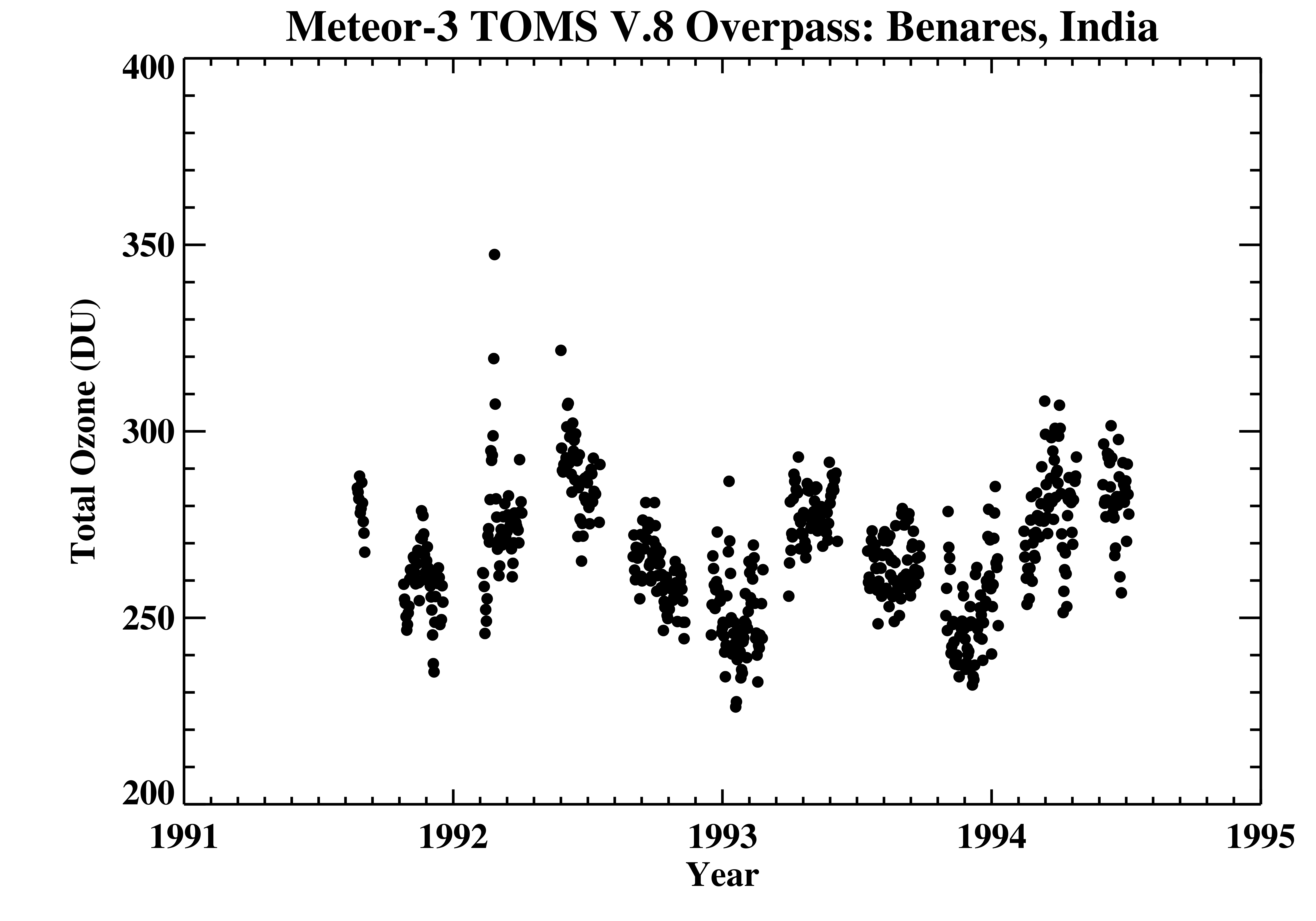
TOMS Meteor-3 Ground Station Overpass Data V008 (TOMSM3OVP) at GES DISC
National Aeronautics and Space Administration —
The Meteor-3 Total Ozone Mapping Spectrometer (TOMS) version 8 daily ground station overpass data product contains total column ozone, UV aerosol index, Lambertian... -
Federal
NOAA-20 VIIRS Global Binned Inherent Optical Properties (IOP) Data, version R2022.0
National Aeronautics and Space Administration —
The Visible and Infrared Imager/Radiometer Suite (VIIRS) is a multi-disciplinary instrument that is being flown on the Joint Polar Satellite System (JPSS) series of... -
Federal
GPM GROUND VALIDATION NASA MICRO RAIN RADAR (MRR) MC3E V1
National Aeronautics and Space Administration —
The GPM Ground Validation NASA Micro Rain Radar (MRR) MC3E dataset was collected by a Micro Rain Radar (MRR), which is a vertically pointing Doppler radar which... -
Federal
NOAA-20 VIIRS Regional Inherent Optical Properties (IOP) Data, version R2022.0
National Aeronautics and Space Administration —
The Visible and Infrared Imager/Radiometer Suite (VIIRS) is a multi-disciplinary instrument that is being flown on the Joint Polar Satellite System (JPSS) series of... -
Federal
DISCOVER-AQ Maryland Deployment Oldtown Ground Site Data
National Aeronautics and Space Administration —
DISCOVERAQ_Maryland_Ground_Oldtown_Data contains data collected at the Oldtown ground site during the Maryland (Baltimore-Washington) deployment of NASA's DISCOVER-AQ... -
Federal
CLAMS ER-2 Moderate Resolution Imaging Spectrometer (MODIS) Airborne Simulator (MAS)
National Aeronautics and Space Administration —
CLAMS_ER2_MAS data were collected during the Chesapeake Lighthouse and Aircraft Measurements for Satellites (CLAMS) experiment with the objective to combine long term... -
Federal
First ISCCP Regional Experiment (FIRE) Cirrus Phase II Colorado State University (CSU) Rawinsonde Data
National Aeronautics and Space Administration —
The First ISCCP Regional Experiments have been designed to improve data products and cloud/radiation parameterizations used in general circulation models (GCMs).... -
Federal
TROPESS AIRS-Aqua L2 Methane for Forward Stream, Standard Product V1 (TRPSDL2CH4AIRSFS) at GES DISC
National Aeronautics and Space Administration —
The TROPESS AIRS-Aqua L2 Methane for Forward Stream, Standard Product contains the vertical distribution of the retrieved atmospheric state of methane (CH4), formal... -
Federal
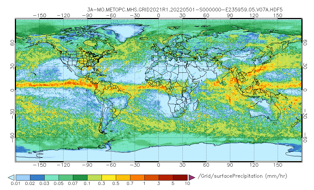
GPM MHS on METOP-C (GPROF) Radiometer Precipitation Profiling L3 1 month 0.25 degree x 0.25 degree V07 (GPM_3GPROFMETOPCMHS) at GES DISC
National Aeronautics and Space Administration —
Version 07 is the current version of the data set. 3GPROF products provide global gridded monthly/daily precipitation averages from multiple satellites that can be...

Official websites use .gov
A
.gov website belongs to an official government
organization in the United States.
Secure .gov websites use HTTPS
A
lock (
) or https:// means you’ve safely connected to
the .gov website. Share sensitive information only on official,
secure websites.